
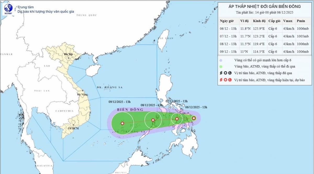
A tropical depression (TLD) is moving from the East of the Philippines and is expected to enter the East Central South China Sea in the next 24-48 hours. The system maintains wind speed of level 6, gusting to level 8 and is likely to cause strong winds and waves of 2-4 meters high from the morning of December 8.
According to the National Center for Hydro-Meteorological Forecasting, a tropical depression is active in the East Central Philippines. The center of the depression is at 11.8°N-125.9°E; the strongest wind is level 6, gusting to level 8, moving west at a speed of 5-10 km/hour.
 |
Forecast for the next 24-48 hours:
At 1:00 p.m. on December 7, the tropical depression moved west-southwest at a speed of 10-15 km/hour, entering the Philippines, at a position of about 11.7°N - 123.2°E; winds remained at level 6, gusting to level 8.
At 1:00 p.m. on December 8, continue moving West Southwest at 15-20 km/hour, entering the East Central East Sea, position 11.5°N-119.4°E; intensity unchanged.
Danger zone in the East Sea: from 10.5-13.0°N, east of longitude 118.0°E.
Disaster risk level: level 3 in the eastern region of the central East Sea.
Warning for the next 48-72 hours
The tropical depression continues to move in the West Southwest direction at a speed of 20-25 km/h, with little change in intensity.
Since early morning of December 8, the eastern area of the central East Sea has experienced strong winds of level 6, gusts of level 8, waves 2-4 meters high, and rough seas. Ships operating in the danger zone should be wary of storms, whirlwinds, strong winds, and large waves.
According to vov.vn
Source: https://baovinhlong.com.vn/tin-moi/202512/ap-thap-nhiet-doi-tien-vao-bien-dong-canh-bao-gio-manh-va-bien-dong-78d30bf/


Comment (0)