
According to the Center for Hydro-Meteorological Forecasting, on the morning of December 7, a tropical depression is active near the East Sea and is likely to affect the southeastern area of the central East Sea in the next 1-2 days.
At 7:00 a.m. on December 7, the center of the tropical depression was at about 12.0 degrees North latitude - 124.3 degrees East longitude, with the strongest wind reaching level 6, gusting to level 8. The depression moved west at a speed of about 15 km/h.
Forecast for the next 24–48 hours:
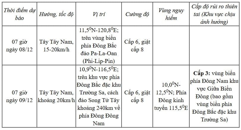 |
Warning for the next 48–72 hours: The tropical depression is forecast to continue moving in the West Southwest direction at a speed of 20–25 km/h and has a tendency to gradually weaken.
Forecast of impacts at sea: From the morning of December 8, the sea area in the southeast of the central East Sea, including the area northeast of Truong Sa archipelago, will have winds gradually increasing to level 6, gusting to level 8, waves 2-4m high, rough seas.
Vessels operating in dangerous areas are at risk of storms, whirlwinds, strong winds and large waves. They need to closely monitor forecasts to have safe shelter plans.
According to vov.vn
Source: https://baovinhlong.com.vn/thoi-su/202512/ap-thap-nhiet-doi-tren-bien-dong-giat-cap-8-va-co-xu-huong-suy-yeu-dan-ad019ad/


Comment (0)