

Northeast wind on land increases to level 3, coastal areas level 4 - 5.
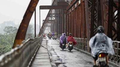
From the night of December 3, the North and North Central regions will turn cold, with some areas in the mountainous areas of the North experiencing severe cold. Nighttime temperatures in many areas are expected to drop sharply, with increased cold air combined with terrain that may cause light fog in the morning.
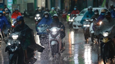
Early on December 2, a band of moist clouds causing rain caused scattered showers and rain in the area from Quang Tri to Da Nang City and from the East of Quang Ngai to Dak Lak. In the next 24 hours, the area from Hue, Da Nang, from the East of Quang Ngai to Dak Lak and Khanh Hoa will continue to have moderate rain, heavy rain, and locally very heavy rain with common rainfall of 40-100 mm, in some places over 150 mm.
Widespread rain in the Central Central region is likely to last until December 5, increasing the risk of flash floods and landslides in mountainous areas and localized flooding in low-lying areas.
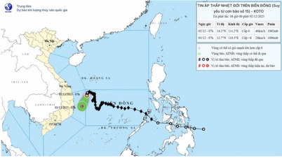
At sea, at 1:00 a.m. on December 2, the center of the tropical depression, the remnant of storm No. 15, was at about 14.4 degrees North latitude and 111.2 degrees East longitude, in the Northwest sea area of the central East Sea. The strongest wind is level 6, gusting to level 8, the tropical depression is moving slowly in the South-Southwest direction.
It is forecasted that by 1:00 a.m. on December 3, the center of the tropical depression will weaken into a low pressure area when entering the sea area from Dak Lak to Khanh Hoa, with winds decreasing to below level 6. The main direction of movement is South-Southwest at a speed of 5-10 km/hour.
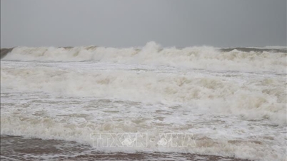
Currently, Ly Son station has recorded Northeast wind level 5, sometimes level 6, gusting to level 7. During the day and night of December 2, the Northwest sea area between the East Sea and off the coast of Gia Lai - Dak Lak maintained strong winds level 6, gusting to level 8, waves 2-4m high, rough seas.
In addition, the sea area west of the central East Sea, southwest of the northern East Sea (including the Hoang Sa sea area) and the sea area from Da Nang to Khanh Hoa will have scattered showers and thunderstorms; in thunderstorms, tornadoes and strong gusts of wind are likely to occur. Ships operating in the area need to regularly update weather information and proactively stay away from dangerous areas to ensure safety.
Weather forecast for regions across the country:
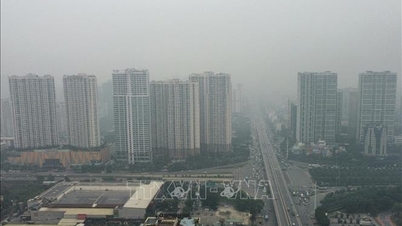
Hanoi capital is cloudy, with rain in some places, sunny in the afternoon. Light wind. Cold in the morning and at night. Lowest temperature 18-20 degrees Celsius. Highest temperature 25-27 degrees Celsius.

The Northwestern provinces are cloudy, sunny during the day, with some rain at night; the eastern Hoang Lien Son region has scattered rain and light rain. Light wind. Cold in the morning and at night, with some places being very cold. The lowest temperature is 14-17 degrees Celsius, the Northwestern region is 11-14 degrees Celsius. The highest temperature is 23-26 degrees Celsius, with some places being over 26 degrees Celsius.
The Northeastern region is cloudy with rain in some places, early morning there is fog in some places, afternoon and evening the clouds are less cloudy and sunny; at night there is rain, scattered light rain. Light wind. Morning and night it is cold, some mountainous areas are very cold. Lowest temperature 16-19 degrees Celsius, mountainous areas 13-16 degrees Celsius, some places below 12 degrees Celsius. Highest temperature 24-27 degrees Celsius.
Provinces from Thanh Hoa to Hue are cloudy, with rain in some places in the North, fog in some places in the early morning, sunny in the afternoon, scattered rain at night; in the South there is rain, scattered showers and thunderstorms in some places, locally heavy rain in some places, especially in Hue city at night there is moderate rain, heavy rain. North to northwest wind level 2-3. In the morning and at night in the North it is cold, in the South it is cold. Lowest temperature 18-21 degrees Celsius. Highest temperature 23-26 degrees Celsius.
South Central Coast region: Cloudy in the North, with rain, showers and thunderstorms during the day, locally heavy rain, moderate rain, heavy rain at night, locally very heavy rain; in the South, showers and thunderstorms in some places. North to northwest wind level 2-3. During thunderstorms, there is a possibility of tornadoes, lightning and strong gusts of wind. Lowest temperature 22-25 degrees Celsius. Highest temperature 25-28 degrees Celsius, in the South 29-32 degrees Celsius.
Central Highlands: Cloudy, scattered showers and thunderstorms. Light winds. Thunderstorms may cause tornadoes, lightning, and strong gusts of wind. Lowest temperature 18-21 degrees Celsius, below 18 degrees Celsius in some places. Highest temperature 27-30 degrees Celsius.
The South is cloudy, sunny during the day, with showers and thunderstorms at night in some places. Light wind. During thunderstorms, there is a possibility of tornadoes, lightning and strong gusts of wind. Lowest temperature 23-26 degrees Celsius. Highest temperature 30-33 degrees Celsius, some places above 33 degrees Celsius.
Ho Chi Minh City is cloudy, sunny during the day, no rain at night. Light wind. Lowest temperature 24-26 degrees Celsius. Highest temperature 32-34 degrees Celsius.
Source: https://baohaiphong.vn/bac-bo-chuyen-ret-trung-trung-bo-tiep-tuc-mua-rat-to-528379.html


![[Photo] Worshiping the Tuyet Son statue - a nearly 400-year-old treasure at Keo Pagoda](/_next/image?url=https%3A%2F%2Fvphoto.vietnam.vn%2Fthumb%2F1200x675%2Fvietnam%2Fresource%2FIMAGE%2F2025%2F12%2F02%2F1764679323086_ndo_br_tempimageomw0hi-4884-jpg.webp&w=3840&q=75)
![[Photo] Parade to celebrate the 50th anniversary of Laos' National Day](/_next/image?url=https%3A%2F%2Fvphoto.vietnam.vn%2Fthumb%2F1200x675%2Fvietnam%2Fresource%2FIMAGE%2F2025%2F12%2F02%2F1764691918289_ndo_br_0-jpg.webp&w=3840&q=75)


Comment (0)