
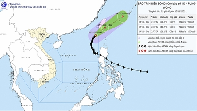
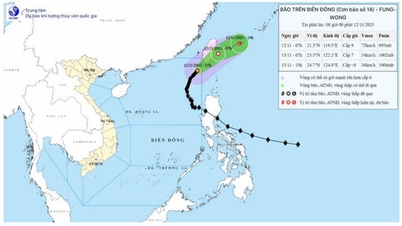
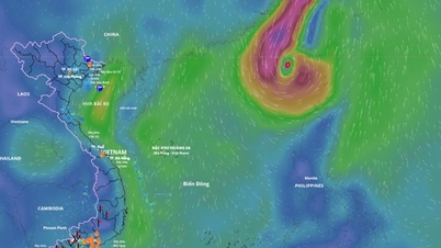
The National Center for Hydro-Meteorological Forecasting said that at 4:00 a.m. this morning, November 11, the center of storm No. 14 (storm Fung Wong) was located at about 19.3 degrees north latitude and 118.1 degrees east longitude, in the eastern sea area of the northern East Sea. The strongest wind near the center of the storm is level 12, equivalent to wind speed from 118 - 133 km/h, gusting to level 15. The storm is moving northwest at a speed of about 10 km/h.
 weakens, changes direction to move out to the East Sea")
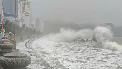
Storm No. 14 (Storm Fung Wong) is moving out to the East Sea. PHOTO: VNDMS
Thus, compared to yesterday, November 10, storm No. 14 has weakened by 1 level and has changed direction of movement from northwest to north-northwest towards the East Sea, and will enter Taiwan (China).
Forecast until 4:00 tomorrow, November 12, the center of the storm is located at about 22.2 degrees north latitude and 119.2 degrees east longitude, in the sea area east of the northern East Sea. The area near the center of the storm has strong winds of level 12, gusting to level 15. The storm moves northeast, at a speed of 10 - 15 km/h. The dangerous area in storm No. 14 is from north of latitude 17.5 degrees north and east of longitude 116.0 degrees east, with a natural disaster risk of level 3.
Forecast by 4:00 a.m. on November 13, the center of the storm is at about 24.3 degrees north latitude and 112.2 degrees east longitude, in the sea east of Taiwan (China) and gradually weakens into a tropical depression, strong winds of level 7, gusts of level 9. Dangerous sea area from north of latitude 20.0 degrees north and east of longitude 116.5 degrees east, natural disaster risk at level 3.
Ships and boats stay away from the danger zone of storm number 14
The National Center for Hydro-Meteorological Forecasting warns that due to the influence of storm No. 14, the eastern sea area of the northern East Sea will have strong winds of level 7-9; the area near the storm's eye will have strong winds of level 10-12, gusting to level 15. Waves will be 4-7 m high, the area near the storm's eye will be 7-9 m. The sea will be very rough.
Accordingly, all ships and boats operating in the above-mentioned dangerous areas are likely to be affected by storms, strong winds, and large waves.
Previously, on November 10, the National Civil Defense Steering Committee sent a telegram to 7 ministries: National Defense, Agriculture and Environment, Public Security, Construction, Industry and Trade, Foreign Affairs , Science and Technology and 13 coastal provinces and cities: Quang Ninh, Hai Phong, Hung Yen, Ninh Binh, Thanh Hoa, Nghe An, Ha Tinh, Quang Tri, Hue, Da Nang, Quang Ngai, Gia Lai, Dak Lak requesting proactive response to storm No. 14 at sea.
In the dispatch, the National Civil Defense Steering Committee requested 13 coastal provinces and cities from Quang Ninh to Dak Lak to strictly manage vehicles going out to sea; organize counting and notify owners of vehicles and captains of ships and boats operating at sea of the location, direction of movement and developments of storm No. 14 so that they can proactively avoid and escape from the danger zone.
On the same day, the Ministry of National Defense issued a dispatch requesting units to closely monitor the developments of storm No. 14 (storm Fung Wong), ensure safety for forces and vehicles when performing tasks at sea; proactively mobilize forces and vehicles to be ready to participate in search and rescue when requested./.
According to Thanh Nien Newspaper
Source: https://thanhnien.vn/bao-so-14-bao-fung-wong-suy-yeu-doi-huong-di-chuyen-ra-ngoai-bien-dong-185251111065526292.htm
Source: https://baolongan.vn/bao-so-14-bao-fung-wong-suy-yeu-doi-huong-di-chuyen-ra-ngoai-bien-dong-a206222.html
![[Photo] Prime Minister Pham Minh Chinh receives Lao Minister of Labor and Welfare Phosay Sayasone](https://vphoto.vietnam.vn/thumb/1200x675/vietnam/resource/IMAGE/2025/11/11/1762872028311_dsc-2246-jpg.webp)


![Dong Nai OCOP transition: [Article 3] Linking tourism with OCOP product consumption](https://vphoto.vietnam.vn/thumb/402x226/vietnam/resource/IMAGE/2025/11/10/1762739199309_1324-2740-7_n-162543_981.jpeg)


Comment (0)