

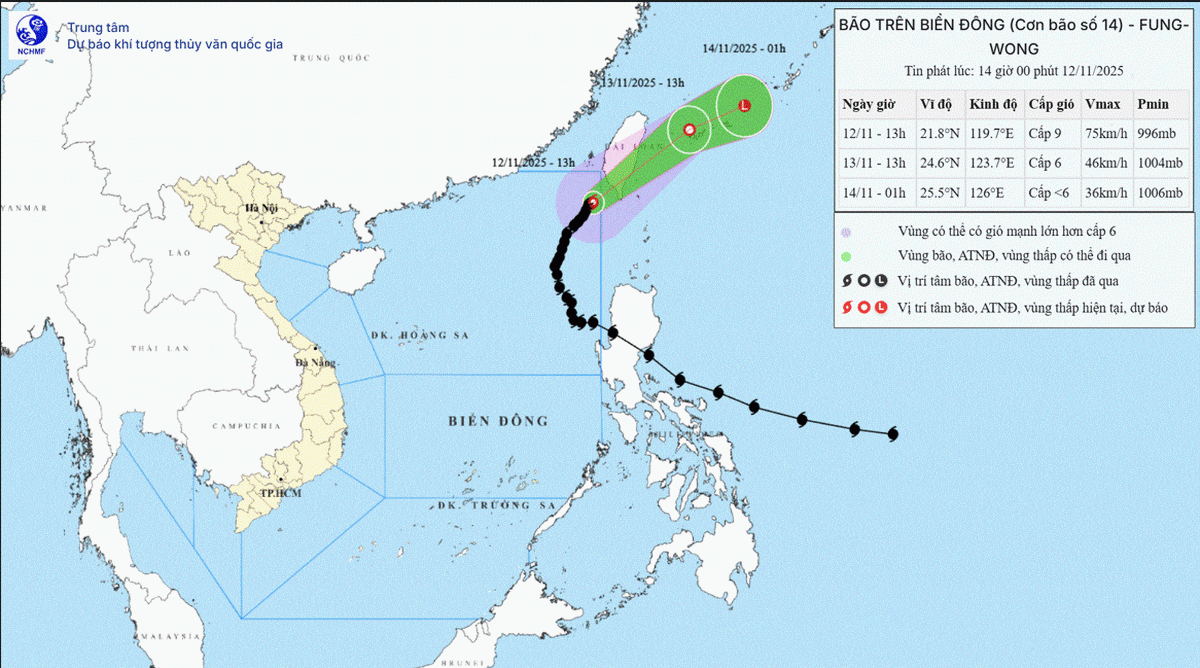
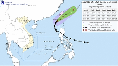
Forecast map of the trajectory and intensity of storm No. 14 issued at 8:00 a.m. on November 12, 2025. (Source: National Center for Hydro-Meteorological Forecasting)
According to the National Center for Hydro-Meteorological Forecasting, at 7:00 a.m. on November 12, the eye of the storm was located at about 21.5 degrees north latitude; 119.5 degrees east longitude, in the northeastern sea area of the northern East Sea. The strongest wind near the eye of the storm was level 8-9 (62-88 km/h), gusting to level 11. Moving northeast at a speed of 10-15 km/h.
As of 7 a.m. on November 13, the storm was moving northeast at a speed of 10-15 km/h. The center of the storm was located at about 23.5 degrees north latitude; 122.1 degrees east longitude, in the sea east of Taiwan (China). The strongest wind near the center of the storm was level 7, gusting to level 10 and gradually weakening into a tropical depression. Natural disaster risk: Level 3 in the northeastern sea area of the northern East Sea.
At 7:00 p.m. on November 13, the tropical depression moved northeast at a speed of 25-30 km/hour, with its center at about 24.7 degrees north latitude and 124.8 degrees east longitude, in the sea northeast of Taiwan (China) and gradually weakened into a low pressure area.
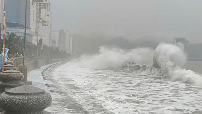
Due to the storm's influence, the northeastern sea area of the northern East Sea has strong winds of level 6-7; the area near the storm's eye has strong winds of level 8-9, gusting to level 11, waves 3-5m high, the area near the storm's eye has waves of 5-7m. The sea is very rough.
All vessels operating in the above-mentioned dangerous areas are susceptible to the impact of storms, whirlwinds, strong winds and large waves./.
According to Nhan Dan Newspaper
Source: https://nhandan.vn/bao-so-14-tiep-tuc-giam-cap-va-suy-yeu-dan-thanh-ap-thap-nhiet-doi-post922382.html
Source: https://baolongan.vn/bao-so-14-tiep-tuc-giam-cap-va-suy-yeu-dan-thanh-ap-thap-nhiet-doi-a206306.html


![Dong Nai OCOP transition: [Article 3] Linking tourism with OCOP product consumption](https://vphoto.vietnam.vn/thumb/402x226/vietnam/resource/IMAGE/2025/11/10/1762739199309_1324-2740-7_n-162543_981.jpeg)


Comment (0)