The National Center for Hydro-Meteorological Forecasting said that on the evening of November 25, a tropical depression in the sea west of the central Philippines strengthened into a storm.
At 7:00 p.m., the storm was in the western sea of the central Philippines, with a level 8 intensity (62-74 km/h), gusting to level 10, moving west-northwest at a speed of 20-25 km/h.
It is forecasted that on the night of November 25 and early morning of November 26, the storm will enter the East Sea, becoming the 15th storm of the year.
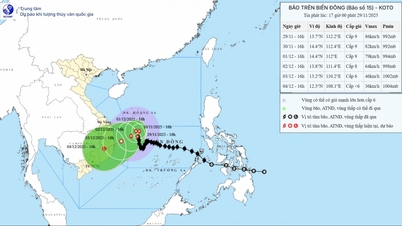
By the evening of November 26, the storm in the eastern sea area of the central East Sea, with intensity of level 9, gusting to level 11, moving mainly in the West Northwest direction at a speed of 20-25km/h, entered the East Sea and has the potential to strengthen.

As of 7 p.m. on November 27, the storm in the central East Sea was at level 10, gusting to level 13, and is likely to continue to strengthen. In the next 24 hours, the storm will move slowly westward at a speed of 5-10 km/h and is likely to strengthen.
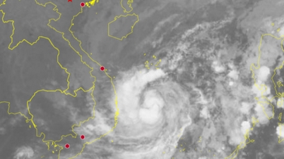
On the evening of November 28, storm number 15 was in the western sea area of the central East Sea with intensity of level 11, gusts of level 13 and has the potential to strengthen.
Thus, after 72 hours in the East Sea, storm No. 15 is forecast to continuously increase in intensity (level 9 to level 11).
Due to the influence of storm No. 15, the eastern sea area in the central East Sea has winds gradually increasing to level 6 - 7; the area near the storm's center has strong winds of level 8 - 9, gusts of level 11, waves 4 - 6m high, very rough seas.
During November 27-28, the central East Sea area (including the sea area north of Truong Sa special zone) is likely to be affected by strong winds of level 10-11, gusts of level 14, waves 7-9m high, and rough seas.
Vessels operating in the above mentioned dangerous areas are susceptible to the impact of storms, whirlwinds, strong winds and large waves.
The Japan Meteorological Agency forecasts that storm No. 15 will reach its peak on November 27, with a speed of up to 108km/h (level 11) and then gradually weaken as it moves towards the South Central region.
Source: https://baolaocai.vn/bao-so-15-se-lien-tuc-tang-cap-khi-vao-bien-dong-post887586.html






















Comment (0)