
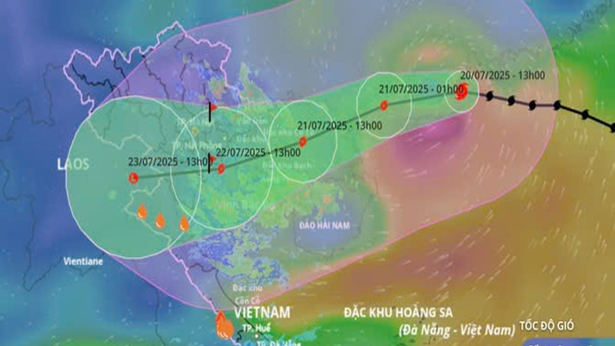
According to the National Center for Hydro-Meteorological Forecasting, at 4:00 p.m. on July 20, the center of the storm was at about 21.8°N; 112.8°E, in the northern sea area of the North East Sea, about 560km east of Quang Ninh - Hai Phong . The strongest wind was level 12 (118-133km/h), gusting to level 15. The storm moved westward at a speed of 20-25km/h.

Forecast until 4:00 p.m. on July 21: Storm in the Northern Gulf of Tonkin (20.7°N–108.5°E), level 11–12, gust level 15.
At 4:00 p.m. on July 22: The storm made landfall along the coast of Hai Phong - Thanh Hoa (20.2°N - 106.2°E), weakening to level 9-10, gusting to level 12.
At 4:00 p.m. on July 23: Over Upper Laos (19.8°N–103.8°E), it weakened into a low pressure area.
Due to the influence of the storm, the northwestern sea area of the North East Sea has winds of level 8-10, near the eye of the storm winds of level 11-12, gusts of level 15, waves 5-7m high, and rough seas. From the night of July 20, the northern Gulf of Tonkin gradually increased to level 6-7, then increased to level 8-9, near the eye of the storm winds of level 10-12, gusts of level 15; waves 3-5m high. The southern Gulf of Tonkin has strong winds of level 6-7, near the eye of the storm winds of level 8-9, gusts of level 11, waves 2-4m high.
On land from the night of July 21, the coast from Quang Ninh to Nghe An will have winds of level 7-9, near the storm center, winds of level 10-11, gusting to level 14; deep inland, winds of level 6-7, gusting to level 8-9.
In Hai Phong - Quang Ninh, the water level will rise by 0.8-1.2m. Highest water level: Hon Dau 3.8-4.2m; Cua Ong 4.8-5.2m; Tra Co 3.8-4.4m. High risk of flooding in coastal areas and river mouths at noon-afternoon of July 22.
The National Center for Hydro-Meteorological Forecasting recommends that no boats operate in the affected areas. People in coastal areas from Quang Ninh to Nghe An should complete reinforcing their houses and evacuate if necessary before July 21. Warnings of flooding, collapse due to strong winds, prolonged heavy rains, and flash floods and landslides in mountainous areas.
Source: https://baolaocai.vn/bao-so-3-dang-o-khu-vuc-bac-bien-dong-cach-hai-phong-quang-ninh-560km-post649292.html


![[Photo] National Assembly Chairman Tran Thanh Man visits Vietnamese Heroic Mother Ta Thi Tran](https://vphoto.vietnam.vn/thumb/1200x675/vietnam/resource/IMAGE/2025/7/20/765c0bd057dd44ad83ab89fe0255b783)


Comment (0)