
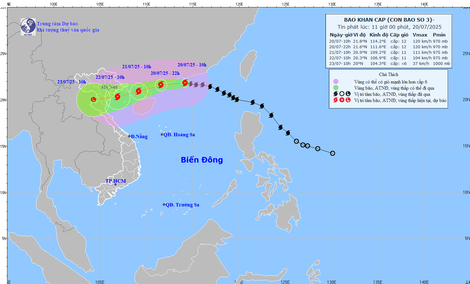
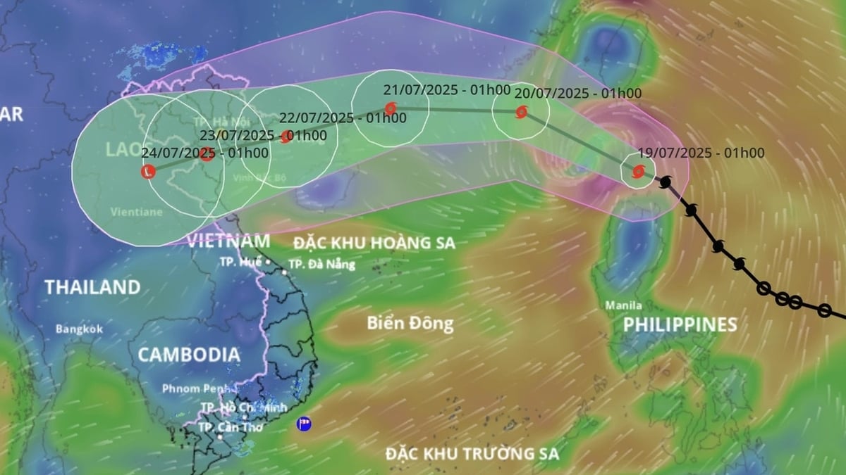
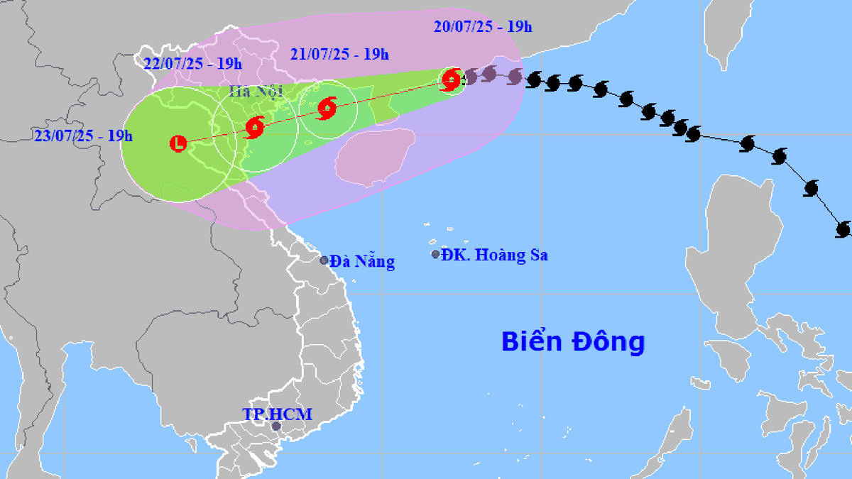
According to the National Center for Hydro-Meteorological Forecasting, at 10:00 a.m. on July 20, the center of the storm was at about 21.8 degrees north latitude; 114.2 degrees east latitude.
East longitude, in the northern sea area of the North East Sea, about 680km east of Quang Ninh - Hai Phong . The strongest wind near the storm center is level 11-12 (103-133km/h), gusting to level 15; moving west at a speed of about 20 - 25km/h.
It is forecasted that in the next 24 - 72 hours, storm No. 3 will move westward, traveling 20 - 25km per hour. At 7:00 a.m. on July 21, the center of storm No. 3 will be located at 21.1 degrees north latitude, 109.8 degrees east longitude, on the mainland north of Leizhou Peninsula (China). The strongest wind near the center of the storm is level 11, gusting to level 14.
From the night of July 20, the northern sea area of Bac Bo Gulf (including Bach Long Vi, Cat Hai, and Cat Ba special zones) will have winds gradually increasing to level 6-7, then increasing to level 8-9, near the storm center level 10-11, gusting to level 14; waves 2.0-4.0m high, near the center 3.0-5.0m. The sea is very rough.
From the evening and night of July 21, the coastal area of Hai Phong (including Cat Hai, Hon Dau - Do Son special zones) will have winds gradually increasing to level 7-9, gusting to level 10-11. Areas near the storm center will have winds of level 10-11, gusting to level 14. Strong winds on land.
From the night of July 21, on land, including wards/communes in the East of Hai Phong, the wind will gradually increase to level 6, level 7, gusting to level 8-9; wards/communes in the West of Hai Phong, the wind will gradually increase to level 5, sometimes level 6, gusting to level 7-8. Areas near the storm center will have level 10-11, gusting to level 14.
All vessels, anchorages, aquaculture areas, sea dykes and other activities in the above sea areas are at very high risk of being affected by storms, whirlwinds, strong winds and large waves. Strong winds can break trees, damage houses, traffic works and infrastructure, endangering human lives.
Storm disaster risk level: level 3.
The coastal area of Hai Phong city has storm surges of 0.5-1.0m, the water level at Hon Dau (Hai Phong) is 3.8-4.1m high. There is a high risk of flooding in low-lying coastal and river mouth areas at noon and afternoon on July 22.
Beware of flooding in some low-lying coastal areas and river mouths due to the effects of high tides and storm surges.
From tonight, July 20, in the Gulf of Tonkin (including Bach Long Vi special zone), there will be heavy to very heavy rain and thunderstorms, with common rainfall from 200-300mm.
From July 21 to July 23, in the Hai Phong sea area (including Cat Hai, Hon Dau - Do Son special zones), there will be heavy to very heavy rain with common rainfall from 150-250mm, locally over 250mm.
From July 21 to July 23, inland areas including wards/communes of Hai Phong city will have heavy to very heavy rain with common rainfall of 150-200mm, locally over 200mm. During thunderstorms, there is a possibility of tornadoes, lightning and strong gusts of wind.
Warning of risk of heavy rain (>150mm/3h).
Thunderstorms and heavy rains overload urban drainage systems, causing flooding in residential areas, traffic jams due to flooded roads and reduced visibility while driving, causing slippery roads and traffic accidents.
Thunderstorms can be accompanied by tornadoes, lightning and strong gusts of wind that can cause trees to fall, damage houses, traffic works and infrastructure. Heavy rain in a short period of time can cause landslides in mountainous areas, flooding urban areas and low-lying areas.
PVSource: https://baohaiphongplus.vn/bao-so-3-giat-cap-14-cach-quang-ninh-hai-phong-khoang-680-km-416793.html


![[Photo] National Assembly Chairman Tran Thanh Man visits Vietnamese Heroic Mother Ta Thi Tran](https://vphoto.vietnam.vn/thumb/1200x675/vietnam/resource/IMAGE/2025/7/20/765c0bd057dd44ad83ab89fe0255b783)


Comment (0)