
.gif)
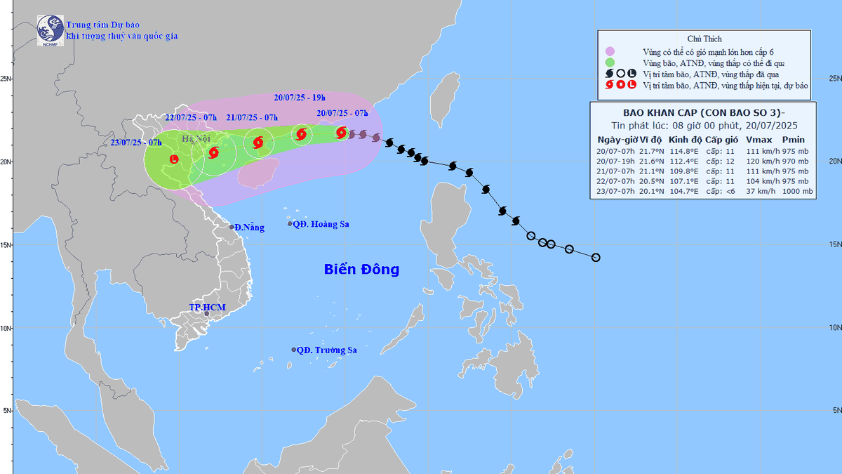
According to the National Center for Hydro-Meteorological Forecasting, at 7:00 p.m. on July 19, the center of storm No. 3 was in the northeastern sea of the northern East Sea, with the strongest wind near the center of the storm reaching 117 km/h, equivalent to level 10-11, gusting to level 14. It is forecasted that by 7:00 p.m. on July 20, the storm will maintain its direction, speed increasing to level 11-12, gusting to level 15, about 220 km east of Leizhou Peninsula (China).
By the evening of July 21, the storm could reach level 10 - 11, gusting to level 13 in the northern waters of the Gulf of Tonkin and turn west-southwest, at a speed of 15 km/h, then make landfall in the Northern Delta with an intensity of about level 8, gusting to level 10.
The Japan Meteorological Agency forecasts that the storm will reach its peak speed of 108 km/h on July 20, then move close to mainland China and down to the northern coastal provinces. The Hong Kong Meteorological Agency said that when entering the Gulf of Tonkin, the storm will maintain a wind speed of 110 km/h, decreasing to 90 km/h when approaching Hai Phong - Quang Ninh.
Mr. Hoang Phuc Lam, Deputy Director of the National Center for Hydro-Meteorological Forecasting, said the storm could reach its strongest intensity of level 12-13, gusting to level 14-15 in the east of the Loi Chau peninsula. Due to the area of rain and strong winds shifting to the west and south, thunderstorms may appear from July 20-21 while the storm is still offshore. It is expected that from the morning of July 22, the storm will begin to directly affect the mainland of Quang Ninh - Thanh Hoa provinces, including Hai Phong, causing strong coastal winds and widespread heavy rain in the North and North Central regions.
Due to the storm's influence, the northern East Sea has strong winds of level 8 - 10, near the storm's eye level 11 - 12, gusts of level 15, waves 5 - 7 m high. From July 21, the northern Gulf of Tonkin (including Bach Long Vi, Co To, Cat Hai, Cat Ba) has winds gradually increasing to level 6 - 7, then increasing to level 8 - 9, near the storm's eye level 10 - 11, gusts of level 14, waves 2 - 4 m high, near the eye 3 - 5 m.
At the regular meeting of the National Steering Committee for Natural Disaster Prevention and Control on July 19, leaders of the Ministry of Agriculture and Environment assessed that storm WIPHA has a similar trajectory to the previous storm Yagi, and may not be as strong but has the risk of causing widespread heavy rain in the North.
PV (synthesis)Source: https://baohaiphongplus.vn/bao-so-3-manh-len-cap-11-giat-cap-14-huong-vao-bac-bo-416751.html


Comment (0)