
The strongest wind near the storm center is level 11 (103 - 117 km/h), gusting to level 14. The storm is forecast to move rapidly in the West-Northwest direction at a speed of 20 - 25 km/h and is likely to strengthen further.
By 4:00 a.m. on July 21, the storm will approach the mainland northeast of Leizhou Peninsula (China), reaching level 11-12, gusting to level 15. The area north of latitude 20 degrees North and from longitude 108.5 - 117.5 degrees East is in the area of direct impact. The level of natural disaster risk in the northern East Sea is warned at level 3.
On the morning of July 22, the storm center will be located in the sea area from Quang Ninh to Ninh Binh (coordinates 20.6 degrees North latitude - 107.4 degrees East longitude), the intensity will decrease slightly to level 10 - 11, gusting to level 14. The storm will continue to move in the West Southwest direction at a speed of about 15km/hour.
By 4:00 a.m. on July 23, storm No. 3 will make landfall in the Northern Delta provinces and Thanh Hoa and gradually weaken into a tropical depression, with winds decreasing to level 6, gusting to level 8. During the period from July 23 to 25, the depression will continue to move west-southwest at a speed of 5-10km/hour and weaken further.
At sea, the North East Sea has strong winds of level 8 - 10, near the storm center level 11 - 12, gusting to level 15. Waves are 5 - 7m high, the sea is very rough. From the night of July 20, the North Gulf of Tonkin (including Bach Long Vi, Co To, Cat Hai) has strong winds of level 8 - 9, near the storm center level 10 - 11, gusting to level 14; waves are 3 - 5m high. The sea is very rough.
Coastal areas from Hai Phong to Quang Ninh may experience storm surges combined with high tides, with combined water levels at Bai Chay reaching 5m and Hon Dau reaching 4.1m. Warning of flooding risk in low-lying areas, river mouths, and coastal areas at noon and afternoon on July 22.
From the night of July 21, the area from Quang Ninh to Thanh Hoa will begin to experience winds gradually increasing to level 7 - 9, gusting to level 10 - 11; areas near the storm's center may reach level 10 - 11, gusting to level 14. Areas deep inland may also record winds of level 6 - 7, gusting to level 8 - 9.
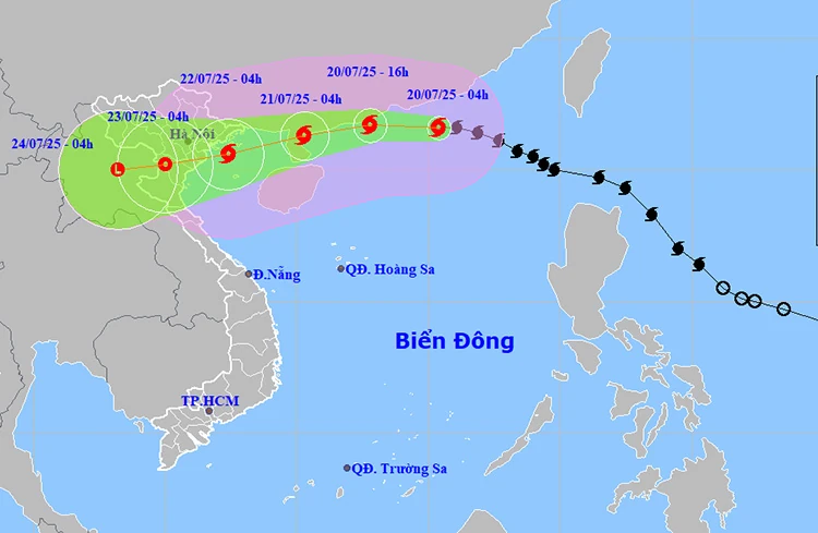
Path and location of the storm. Photo: thoitietvietnam
From July 21 to 23, the North and North Central regions are likely to experience widespread heavy rain. Rainfall is generally between 100 - 200mm, with some places over 300mm. Particularly in the Northeast, the Northern Delta, Thanh Hoa and Nghe An, there may be very heavy rain, with rainfall from 200 - 350mm, locally over 600mm.
Thunderstorms with the risk of tornadoes, lightning, and strong gusts of wind. Since the afternoon of July 20, many areas in the North and North Central regions have begun to experience showers, with localized heavy rains of over 80mm. The risk of extreme rain of over 150mm/ 3 hours during the period from July 21 to 23 is very high.
Storm No. 3 is assessed to cause level 3 natural disaster risk in the North East Sea, the Gulf of Tonkin and coastal provinces from Quang Ninh to Thanh Hoa. The risk of heavy rain in the North and North Central regions is warned at level 1, but there is a high risk of flash floods on small rivers and streams, landslides in mountainous areas and flooding in urban areas and low-lying areas.
On land on July 20, the Northern and North Central regions continued to have scattered showers and thunderstorms, locally heavy rain with rainfall ranging from 20 - 40mm, some places could exceed 80mm. At the same time, in the afternoon and night of July 20, the Central Highlands and the South also recorded scattered showers and thunderstorms, some places had heavy rain ranging from 10 - 30mm, some places over 60mm.
Notably, the risk of heavy rain over 80mm 3 / hour may occur in some areas, increasing the risk of accompanying natural disasters such as tornadoes, lightning, hail and strong gusts of wind during thunderstorms.
Given the complex weather conditions, the meteorological agency has warned that from the afternoon of July 21 to July 23, the North and North Central regions are likely to experience widespread heavy rain. The average rainfall during this period is from 100 - 200mm, with some places exceeding 300mm. Particularly, the Northeast region, the Northern Delta and Thanh Hoa and Nghe An provinces may experience very heavy rain with a total rainfall of 200 - 350mm, locally exceeding 600mm.
Hanoi capital is cloudy, with occasional showers and thunderstorms, locally heavy rain. Northwest wind level 2 - 3. During thunderstorms, there is a possibility of tornadoes, lightning and strong gusts of wind. Lowest temperature 25 - 27 degrees Celsius. Highest temperature 33 - 35 degrees Celsius.
The Northwest region is cloudy with scattered showers and thunderstorms, locally heavy rain. Light wind. Thunderstorms may cause tornadoes, lightning, hail and strong gusts of wind. The lowest temperature is 23 - 26 degrees Celsius, some places below 23 degrees Celsius. The highest temperature is 31 - 34 degrees Celsius, some places above 34 degrees Celsius.
The northeastern provinces are cloudy with scattered showers and thunderstorms, with some places experiencing heavy rain. Northwest winds level 2-3. There is a possibility of tornadoes, lightning, hail and strong gusts of wind during thunderstorms. The lowest temperature is 24-27 degrees Celsius. The highest temperature is 31-34 degrees Celsius, with some places above 34 degrees Celsius.
Provinces from Thanh Hoa to Hue are cloudy, with scattered showers and thunderstorms; in the North, there will be scattered showers and thunderstorms, with some heavy rain. Southwesterly winds level 2-3. During thunderstorms, there is a possibility of tornadoes, lightning, hail and strong gusts of wind. Lowest temperature 26-29 degrees Celsius. Highest temperature 32-35 degrees Celsius.
The South Central Coast region is cloudy, sunny during the day, hot in the North, showers and thunderstorms in the evening and at night in some places. Southwest wind level 3. During thunderstorms, there is a possibility of tornadoes, lightning, hail and strong gusts of wind. The lowest temperature is 26 - 29 degrees Celsius. The highest temperature is 33 - 36 degrees Celsius, some places are over 36 degrees Celsius.
Central Highlands cloudy, afternoon and night showers and scattered thunderstorms, locally heavy rain. Southwest wind level 3. Thunderstorms are likely to have tornadoes, lightning and strong gusts. Lowest temperature 20 - 23 degrees Celsius. Highest temperature 26 - 29 degrees Celsius.
The South is cloudy, with scattered showers and thunderstorms in the afternoon and at night, with heavy rain in some places. Southwesterly wind level 3. There is a possibility of tornadoes, lightning and strong gusts of wind in thunderstorms. Lowest temperature 24 - 27 degrees Celsius. Highest temperature 29 - 32 degrees Celsius, some places above 32 degrees Celsius.
Ho Chi Minh City is cloudy, with scattered showers and thunderstorms in the afternoon and at night, with heavy rain in some places. Southwesterly wind level 3. There is a possibility of tornadoes, lightning and strong gusts of wind during thunderstorms. Lowest temperature 25 - 27 degrees Celsius. Highest temperature 30 - 32 degrees Celsius.
According to VNA/Tin Tuc and Dan Toc Newspaper
Source: https://baoquangtri.vn/bao-so-3-tien-vao-dat-lien-canh-bao-mua-lon-gio-giat-manh-196000.htm


![[Photo] National Assembly Chairman Tran Thanh Man visits Vietnamese Heroic Mother Ta Thi Tran](https://vphoto.vietnam.vn/thumb/1200x675/vietnam/resource/IMAGE/2025/7/20/765c0bd057dd44ad83ab89fe0255b783)


Comment (0)