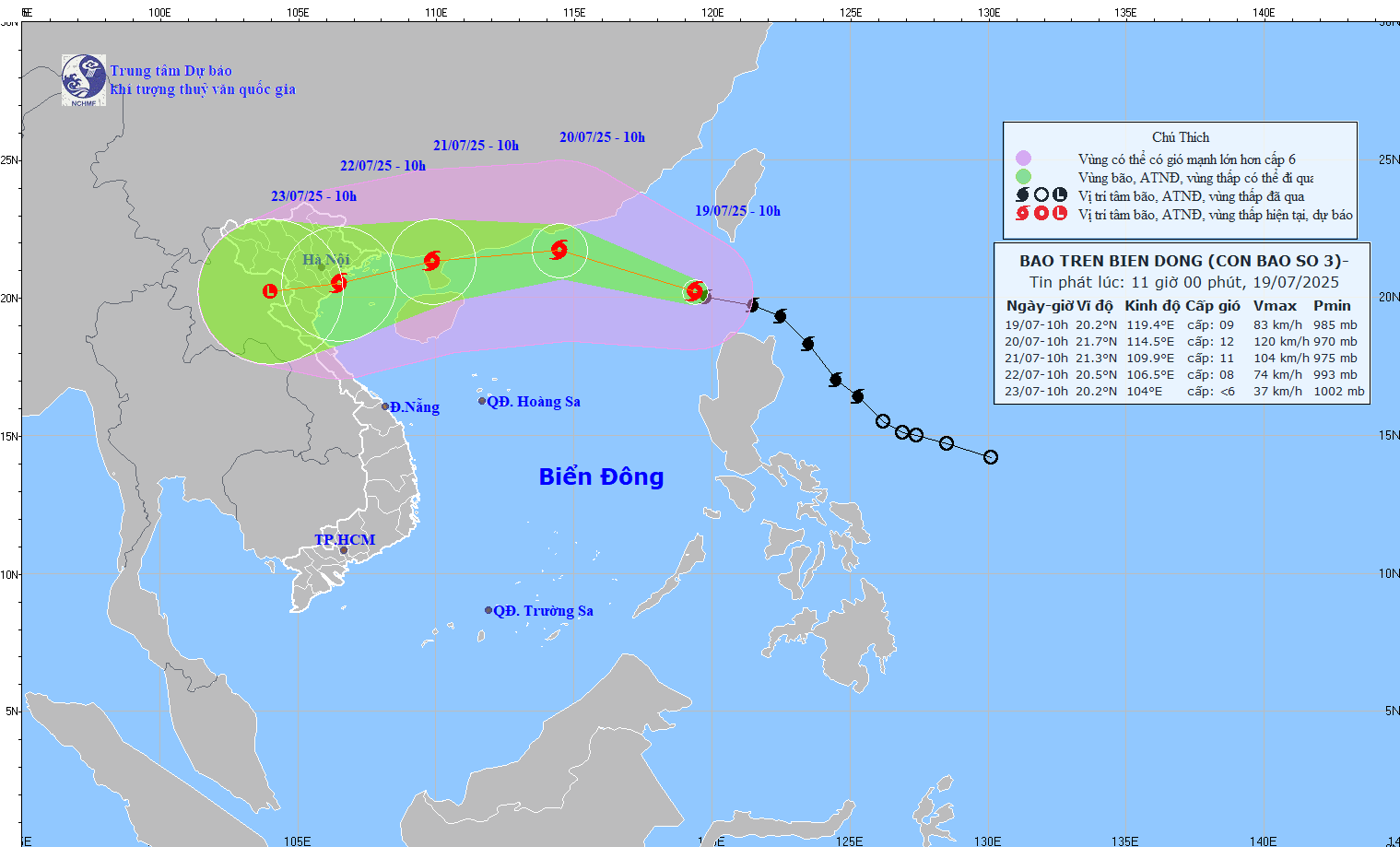
According to the National Center for Hydro-Meteorological Forecasting, at 10:00 a.m., the eye of the storm was located at approximately 20.2 degrees North latitude; 119.4 degrees East longitude, in the northeastern sea area of the North East Sea. The strongest wind near the eye of the storm was level 9 (75 - 88 km/h), gusting to level 11; moving northwest at a speed of approximately 20 km/h.
As of 10:00 a.m. on July 20, the storm was moving west-northwest at a speed of 20-25 km/h. The center of the storm was located at approximately 21.7 degrees north latitude - 114.5 degrees east longitude, approximately 450 km east of Leizhou Peninsula (China). The storm intensity reached level 11-12, gusting to level 15.
The dangerous area in the East Sea at this time is between 18.0 and 23.0 degrees North latitude, east of longitude 112.5 degrees East.
The entire northeastern region of the North East Sea is placed at level 3 natural disaster risk.
At 10:00 a.m. on July 21, the storm was moving mainly westward at a speed of about 20 km/h, entering the mainland north of Leizhou Peninsula (China). The storm center was at about 21.3 degrees North latitude - 109.9 degrees East longitude, with a wind intensity of level 10 - 11, gusting to level 13.
The danger zone extends from the north of latitude 19.5 degrees North, longitude 108.0 - 117.0 degrees East, including the north of the East Sea and the sea area east of the Gulf of Tonkin. The disaster risk level continues to be maintained at level 3.
At 10:00 a.m. on July 22, the storm changed direction to West Southwest at a slower speed (10-15 km/h) and gradually weakened.
Due to the impact of the storm, the northeastern sea area of the North East Sea has strong winds of level 8-9, then increasing to level 10, the area near the storm's center has strong winds of level 11-12, gusting to level 15; waves are 4.0-6.0m high. The sea is very rough.
Ships operating in the above-mentioned dangerous areas are likely to be affected by storms, whirlwinds, strong winds, and large waves. The storm's developments remain complicated.
People in coastal and inland areas from Quang Ninh to Nghe An need to closely monitor the next forecast bulletins and proactively prevent the risk of heavy rain, flash floods, landslides and strong winds.
Dr. Nguyen Ngoc Huy, an expert on climate change and natural disaster warning, said that storm Wipha will create waves 3.8m - 4.8m high along the coasts of Quang Ninh, Hai Phong, Nam Dinh, Thai Binh and Thanh Hoa on the evening of July 21 and July 22.
The areas with the highest waves are the coastal areas of Quang Ninh and Hai Phong with wave heights of up to 4.8 m. The areas of Thai Binh, Nam Dinh , and Thanh Hoa have waves 3.5-3.8 m high.
Source: https://baohaiphongplus.vn/bao-so-3-vao-bien-dong-dang-di-chuyen-rat-nhanh-du-bao-anh-huong-truc-tiep-den-hai-phong-416717.html


Comment (0)