
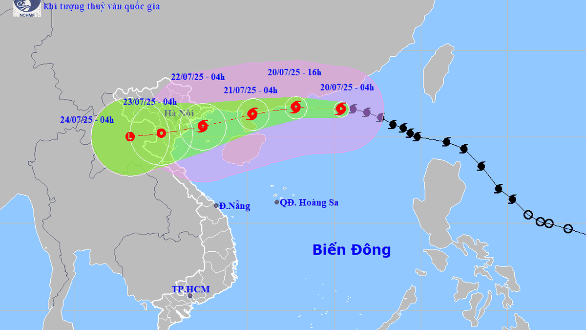
Mr. Hoang Phuc Lam, Deputy Director of the National Center for Hydro-Meteorological Forecasting, said that at 10:00 p.m. on July 19, the center of storm Wipha (storm No. 3) was active in the northern sea area of the North East Sea.
The strongest wind near the storm center is level 10-11 (89-117km/h), gusting to level 14. The storm moves in a West Northwest direction at a speed of about 20-25km/h.
According to the forecast, on July 20, the storm will move in a West-Northwest direction, then West at a speed of 20-25km/h and is likely to strengthen to level 11-12, gusting to level 15. At this time, the storm's center is in the Northwestern sea of the North East Sea, about 130km east of Leizhou Peninsula (China).
.")
It is forecasted that by 10:00 p.m. on July 21, the storm will move in a West-Southwest direction, moving about 15km per hour and decreasing to level 10-11, gusting to level 13 in the northern Gulf of Tonkin.
The Hydrometeorological Agency forecasts that at around 10 p.m. on July 22, the storm will continue to move in a West-Southwest direction with a level 9 intensity, gusting to level 10, and gradually weaken over the mainland of the Northern Delta and Thanh Hoa .
From the next 72 to 96 hours, storm Wipha will move mainly in the West Southwest direction, traveling 5-10km per hour and continue to weaken further.
Due to the influence of the storm, the northern sea area of the North East Sea has strong winds of level 8-10, the area near the storm's eye has winds of level 11-12, gusting to level 15; waves are 5-7 high, the sea is very rough.
From July 21, the sea area in the northern Gulf of Tonkin (including the special areas of Bach Long Vi, Co To, Cat Hai) will have winds gradually increasing to level 6-7, then increasing to level 8-9, the area near the storm's center will have winds of level 10-11, gusting to level 14; waves 2-4m high, 3-5m near the center, rough seas.
It is forecasted that from the afternoon of July 21, the sea area in the southern part of the Gulf of Tonkin will have winds gradually increasing to level 6-7, near the center of the storm level 8-9, gusting to level 11, waves 2-4m high, very rough seas. Ships operating in the above-mentioned dangerous areas are likely to be affected by storms, whirlwinds, strong winds, and large waves.
The Hydrometeorological Agency said that from the evening of July 19 to July 24, the Northern and North Central regions, including provinces such as Quang Ninh, Thanh Hoa, Nghe An, and Ha Tinh, will have heavy to very heavy rain.
Source: https://baolaocai.vn/bao-wipha-dang-tang-cap-huong-vao-bac-bo-post649241.html


Comment (0)