

According to the Ca Mau Province Hydrometeorological Station, the peak tide in this area has continuously remained at a high level and has set a new historical tidal mark. Specifically, the peak tide level at the Ca Mau Hydrological Station reached 1.21m, exceeding the alarm level III (0.85m) by 0.36m, exceeding the historical peak tide in 2023 by 0.05m; at Phuoc Long Hydrological Station, the highest peak tide level reached 1.20m, exceeding the alarm level 3 (0.90m) by 0.3m, exceeding the historical peak tide in 2023 by 0.01m.
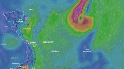
In particular, the high tide from November 3-12, 2025 is warned to be very strong. Specifically, at Ganh Hao station, the highest peak tide is forecast to exceed alert level III by 30-35 cm, reaching 2.50 - 2.55 meters. The flood disaster risk warning has been raised to level 2.
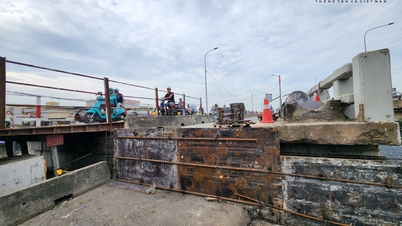
According to many residents in An Xuyen ward, Tan Thanh ward (center of Ca Mau province), high tides have caused flooding on many streets such as Phan Ngoc Hien, Tran Van Thoi, Bui Thi Truong, etc., making it difficult for people to travel and do daily activities.
Mr. Nguyen Chi Nguyen, a resident of Tan Thanh ward, said: "Every year, flooding on inner-city roads rarely happens, but this year the flooding lasted longer and the water level rose higher than the same period in many years."
In Bac Lieu ward (the center of the old Bac Lieu province), from the beginning of October 2025 until now, high tides and prolonged heavy rains have caused deep flooding on many inner-city roads and many low-lying areas in residential areas in the area. In addition, due to the continuous flooding, many roads have been damaged, and many "potholes" have appeared on the road surface, posing many potential traffic accident risks.
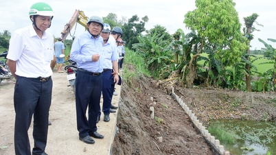
According to the leader of Bac Lieu Ward People's Committee, the ward is coordinating with the Construction Project Management Board to urgently implement anti-flooding projects in the inner city such as: dredging Tran Quynh culvert (section from Cau Xang to Vo Thi Sau street), upgrading Tran Phu street, Bac Lieu river embankment project,... Along with that, implementing to fix damaged points on the roads to limit the risk of traffic accidents and traffic jams in the area during rush hours.
According to Mr. Huynh Minh Nhan, Director of the Hydrometeorological Station of Ca Mau province, the highest water level observed at Ganh Hao station reached 2.15m, exceeding alarm level 2 (2.00m) by 0.15m; at Ca Mau station reached 1.14m, exceeding alarm level 3 (0.85m) by 0.29m; at Phuoc Long station (Quan Lo - Phung Hiep canal) reached 1.13m, exceeding alarm level 3 (0.90m) by 0.23m; at Nam Can station reached 1.59m, approximately exceeding alarm level 3 (1.60m), at Song Doc station reached 1.13m, exceeding alarm level 3 (0.95m) by 0.18m.
According to the Director of the Hydrometeorological Station of Ca Mau province, Huynh Minh Nhan, due to the influence of high tides, flooding occurred in low-lying areas along rivers, canals, and areas outside the dykes. Specifically, the affected communes and wards are: Ganh Hao, Tan Thuan, Tan Tien, Tam Giang, Lang Tron, Gia Rai, Phuoc Long, Vinh Thanh, Phong Hiep, Phong Thanh, Song Doc,... In addition, low-altitude roads in inner-city wards are flooded such as: Ly Bon, De Tham, Le Lai,.... (An Xuyen ward), Bui Thi Truong, Tran Hung Dao, Nguyen Khuyen, Phan Ngoc Hien, Hung Vuong streets (Tan Thanh ward).
The time of the greatest flooding is from 05:00-10:30 and 19:00-23:30 from November 11-12, 2025. The flooding depth is about 10-25cm, in some places over 25cm. Warning level of natural disaster risk due to level 2 flooding.
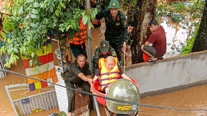
Faced with the complicated developments of high tides, the Steering Committee for Natural Disaster Prevention and Search and Rescue of Ca Mau province has urgently directed localities to closely monitor the situation. Strengthen control, reinforce dykes, embankments and operate water regulation through sluice and dam systems. Local authorities recommend that people in low-lying areas, along rivers and coastal areas proactively take preventive measures such as elevating assets, cutting off electricity at flooded areas and limiting travel during peak tide hours to ensure absolute safety for life and property.
Source: https://baotintuc.vn/xa-hoi/ca-mau-trieu-cuong-vuot-ky-luc-gay-kho-khan-sinh-hoat-nguoi-dan-20251111160640800.htm


![[Photo] Prime Minister Pham Minh Chinh receives Lao Minister of Labor and Welfare Phosay Sayasone](https://vphoto.vietnam.vn/thumb/1200x675/vietnam/resource/IMAGE/2025/11/11/1762872028311_dsc-2246-jpg.webp)


![Dong Nai OCOP transition: [Article 3] Linking tourism with OCOP product consumption](https://vphoto.vietnam.vn/thumb/402x226/vietnam/resource/IMAGE/2025/11/10/1762739199309_1324-2740-7_n-162543_981.jpeg)


Comment (0)