
According to the National Center for Meteorological and Hydrological Forecasting, over the past 24 hours (from 9:00 AM on May 21st to 9:00 AM on May 22nd), the provinces of Tuyen Quang, Thai Nguyen, Cao Bang , Lang Son, and Quang Ninh experienced moderate to heavy rainfall, with some areas receiving very heavy rain, such as: Trung Thanh 348.4mm (Tuyen Quang); Coc Dan 171.8mm (Thai Nguyen); Tan Hoa 72.5mm (Lang Son); Quang Ha 115.8mm (Quang Ninh);... Soil moisture models indicate that some areas in these provinces are near saturation (over 85%) or have reached saturation.

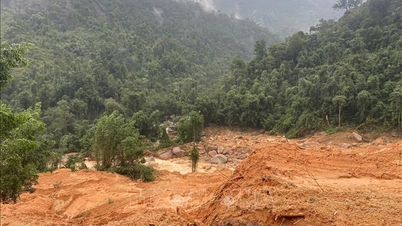
Flash flood and landslide warnings issued for northern provinces.
Over the next 3-6 hours, the aforementioned provinces will continue to experience rain with accumulated rainfall generally ranging from 5-15mm, and in some areas exceeding 40mm. Over the next 6 hours, there is a risk of flash floods on small rivers and streams, and landslides on slopes in many communes/wards. The warning level for natural disaster risk due to flash floods, landslides, and land subsidence caused by rain or runoff is Level 1.
Flash floods and landslides can have very serious impacts on the environment, threatening people's lives; causing localized traffic congestion, affecting the movement of vehicles; destroying public and economic infrastructure, causing damage to production and socio-economic activities.
We recommend that local authorities take note of and review bottlenecks and vulnerable locations in the area to implement preventive and response measures.
List of areas at risk of flash floods and landslides:
Tuyen Quang : Bach Ngoc, Con Lon, Dong Tam, Linh Ho, Tan Quang, Vi Xuyen, Yen Hoa; Thuong Lam; Hong Thai, Lam Binh, Phu Linh, Tan An, Thuong Nong, Thuong Son, Viet Lam.
Thai Nguyen: Hiep Luc, Na Phac, Ngan Son, Phong Quang; Bang Van, Cam Giang, Cao Minh, Phu Thong; Bach Thong, Bang Thanh, Binh Yen, Cho Don, Dinh Hoa, Kim Phuong, Nghia Ta, Nghien Loan, Nghinh Tuong, Phuc Loc, Thuong Quan, Yen Phong
Cao Bang: Nguyen Binh, Tam Kim, Minh Tam, Minh Khai, Bach Dang.
Lang Son: Chau Son, Thien Long, Tan Tri, Vu Le
Quang Ninh: Dam Ha, Hai Son, Mong Cai Ward 3, Quang Ha; Van Don Special Economic Zone, Duong Hoa, Hai Ninh, Ky Thuong, Mong Cai Ward 1, Mong Cai Ward 2, Quang Duc, Quang Tan, Tien Yen.
Flood warning issued for the Thuong River.
The floodwaters in the lower Thuong River are rising slowly. At 8:00 AM on May 22nd, the water level at the Phu Lang Thuong station was 4.02m, 0.28m below Warning Level 1 (WL1). Today and tomorrow (May 23rd), the floodwaters in the lower Thuong River will continue to rise slowly and fluctuate around Warning Level 1 (WL1).
There is a high risk of flooding in low-lying riverside areas, flash floods, and landslides on slopes in Lang Son and Bac Ninh provinces (real-time warning information on flash flood and landslide risk areas is provided online on the website of the National Meteorological and Hydrological Service at: https://luquetsatlo.nchmf.gov.vn and in separate flash flood and landslide warning bulletins). Flood disaster risk level warning: Level 1.
Flooding on rivers and streams can cause inundation in low-lying areas along the riverbanks, affecting activities such as waterway transportation, aquaculture, agricultural production, people's lives, and socio-economic activities.
Source: https://suckhoedoisong.vn/canh-bao-lu-quet-sat-lo-dat-o-5-tinh-mien-bac-169260522103944453.htm


Comment (0)