
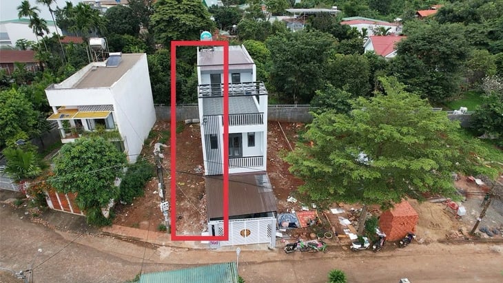
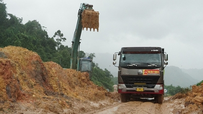
Mr. H.'s house in Tan An ward ( Dak Lak province) encroaches on his neighbor's land by 1.4-2.5m according to the private company's measurements - Photo: TR.TAN
The article "Dispute with neighbors over building a house according to the coordinates of a private company" posted on Tuoi Tre Online received many responses from readers.
Many readers suggested that to avoid unnecessary disputes, each person should proactively build fences and protect land.
Buy land and build a fence to avoid building mistakes.
Reader Hoangminhvu wrote: "After buying land, build a fence to be safe, everyone!". Another reader agreed: "Exactly, the land I have lived on for 40 years still needs to be solidly built."
Reader Thuong Dan believes that many people intentionally build wrongly, and when neighbors point it out, they challenge them to sue. Therefore, this reader requests that the authorities check and review for accuracy.
Returning to the incident mentioned in the article, Mr. Hien emphasized: "The Ward People's Committee invited him to work, the house builder confirmed that he built incorrectly and discussed land swapping. Now, Mr. H. suddenly continues to build incorrectly with the reason that he built according to the coordinates of a private surveying company, which is unacceptable.
Mr. H. must understand that the land use rights are recognized by the State, and cannot ignore the government's mediation to follow the vague coordinates provided by the private surveying company. Now, Mr. H. must take responsibility for his mistake."
Thanhpst also believes that once a building permit has been granted, there must be a step of handing over the coordinates according to the permit. But in reality, the homeowner does not know who to ask and no one hands over the coordinates according to the permit. Therefore, "coordinate errors are always latent".
Some readers believe that the surveying company should be held responsible for the incident mentioned in the article. Reader with the email address Đjuka****@gmail.com believes that "the unit that measured the land boundaries and locations should be sued. They must compensate for all the damage they caused."
Reader Huy Hoang suggested: "Recheck the measurement. If the measurement is correct, it is correct. If the measurement is incorrect, the measuring party is responsible. If they measure correctly, the document issuer must speak up. If they issue the wrong documents, they must take responsibility. The house builder is completely not at fault in this matter."
Meanwhile, reader baonguyen has a different perspective on the incident, saying that the coordinates are common numbers that have been issued, so both private and state-owned companies are equally accurate.
A reader who regularly comments on Tuoi Tre Online with the name Sao Xet analyzes: "When buying or being granted land, people need to invite the ward or commune land authority to come to the land plot to determine the location and assign the land boundaries. The land authority will plant stakes, stretch ropes and make a record of the assignment.
The landowner should pour concrete pillars as markers, build a fence, hire someone to drive piles for the foundation, or dig and build the foundation right away. Because when there are no houses built around, they can freely drive piles and build the foundation. In the above case, they should sue in court.
Is the error due to the measuring unit or the management agency?
However, some readers have questioned: when placing markers according to the coordinates recorded in the red book, it is difficult for the surveying company to make mistakes, and it is possible that the construction is wrong because the coordinates recorded in the red book are incorrect?
Reader Vu Duc wrote: "If that's true, then this is a loophole in the issuance of land use right certificates. Private companies operating in this field must also have a license and the construction coordinates on the certificate must be clearly stated, allowing for extremely small errors."
On the contrary, some readers also think that the measurement company may have made a mistake. Thai Long asked: "The measurement results of private companies are only for reference, not legal. Because they may measure according to the VN2000 standard, but the equipment, process, and people who perform it may not be of guaranteed quality, what if there are shortcomings in the implementation process?".
Reader named Truong provided additional information: he once measured the field according to VN2000 coordinates in an area but the land location on the book was very different from the current status. And according to the coordinates, his land was in the middle of the plot of land next door.
Reader CAN suggested that it is necessary to clarify whether the coordinates on the red book are accurate or not. If the coordinates are accurate but different from the actual coordinates, it is necessary to assign responsibility to the unit that measured when issuing the red book to Mr. H.
Meanwhile, reader Nguyen Van Chu wrote: "Building according to the coordinates on the red book is the most legal basis, but if the coordinates recorded on the red book are incorrect compared to the actual landmarks, the fault lies with the agency that issued the red book." This reader also pointed out Mr. H's fault "is that when a boundary dispute occurs, it is necessary to go to the ward or commune to request the land registry to confirm it again, if the coordinates are incorrect, it is necessary to adjust the red book."
Another reader said that we must follow the reality, not the projection because it is not accurate. One inch wrong can lead to a mile off course. If there is a rain gutter encroaching on the land of the neighbor, then the projection coordinates will be very different from the overall planning diagram. We need to look at the actual border and the original planning diagram.
Source: https://tuoitre.vn/co-tinh-xay-nham-tren-dat-nguoi-khac-hang-xom-noi-con-thach-thuc-di-kien-di-2025110111055954.htm
![[Photo] Lam Dong: Images of damage after a suspected lake burst in Tuy Phong](https://vphoto.vietnam.vn/thumb/1200x675/vietnam/resource/IMAGE/2025/11/02/1762078736805_8e7f5424f473782d2162-5118-jpg.webp)

![[Photo] President Luong Cuong receives US Secretary of War Pete Hegseth](https://vphoto.vietnam.vn/thumb/1200x675/vietnam/resource/IMAGE/2025/11/02/1762089839868_ndo_br_1-jpg.webp)


Comment (0)