Accordingly, at 10:00 a.m. on November 26, storm No. 15 was about 330km east-northeast of Song Tu Tay Island. The strongest wind near the storm center was level 8-9 (62-88km/h), gusting to level 11; moving west-northwest at a speed of 20-25km/h.
It is forecasted that from November 26 to 28, storm No. 15 will move in the West-Northwest direction, then move mainly in the West direction at a speed of about 20km/hour; from November 28, the storm is likely to change its direction of movement and there are different possibilities regarding the storm's path and impact on the seas as well as the mainland of Vietnam.
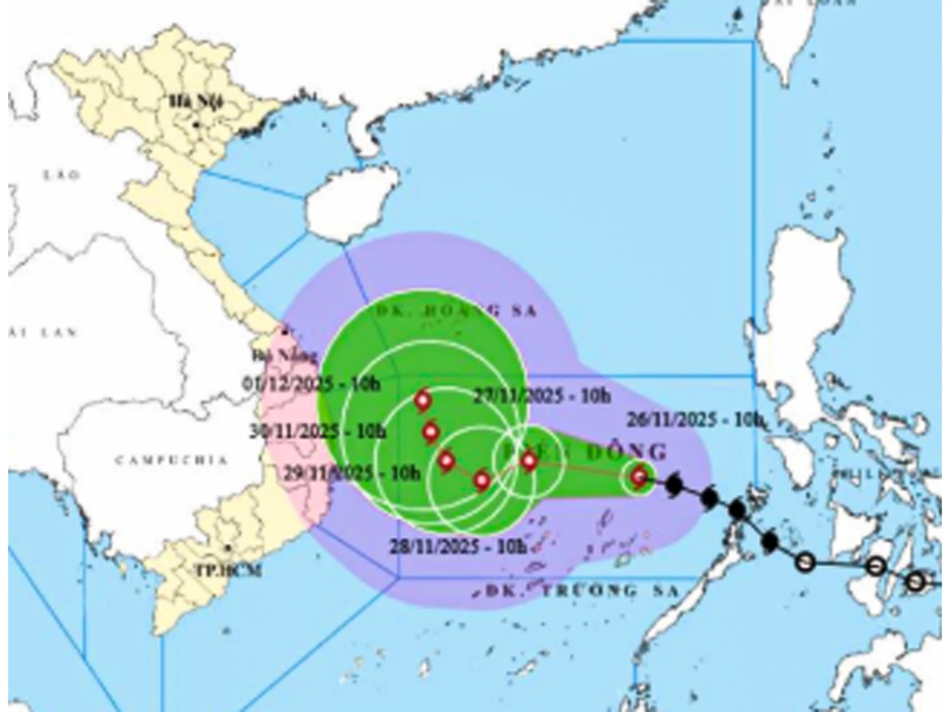 |
| Location and forecast direction of storm number 15. |
Specifically, according to the analysis of the professional agency, scenario 1 (probability 70%): that is, the storm changes direction to the North when reaching the Northwestern sea of Truong Sa special zone (about 500km east of the Gia Lai - Khanh Hoa coast), the storm changes direction to move to the North, weakens into a low pressure area, then this low pressure area is likely to drift towards the mainland of the Central provinces.
With this scenario, the sea area east of the central East Sea will have winds gradually increasing to level 6-7; the area near the storm center will have strong winds of level 8-9, gusts of level 11, waves 4-6m high, and very rough seas. From November 27, the central East Sea area (including the sea area north of Truong Sa special zone) will likely be affected by strong winds of level 10-11, gusts of level 14, waves 7-9m high, and rough seas. There is little chance of storms on land.
Regarding rain, the area from Da Nang to Lam Dong is likely to experience a large-scale heavy rain in the first days of December 2025, focusing on coastal areas. According to current analysis, the possibility of rain is not as extreme as the rain from November 16 to 21.
Scenario 2 (20% probability): this is the worst scenario, the storm does not change direction but goes straight into the Gia Lai - Khanh Hoa area. The storm's strongest intensity in the northern area of Truong Sa special zone can reach level 11, gusting to level 13. After that, it moves west towards the mainland of the Central provinces, focusing on the Gia Lai - Khanh Hoa area. The storm's intensity will weaken to level 8 or tropical depression.
With this scenario, the coastal area from Da Nang to Lam Dong from November 29 will have strong winds of level 8, gusts of level 10, waves 3-5m high, rough seas; there may be heavy rain of 150-250mm between November 29 and December 1. According to current analysis data, the possibility of rain is not as extreme as the recent rain.
Scenario 3 (10% probability): The storm dissipates at sea and does not affect our mainland.
H.D
Source: https://baokhanhhoa.vn/xa-hoi/202511/du-bao-3-kha-nang-xay-ra-cua-bao-so-15-22952ed/






















Comment (0)