
News of tropical depression near the East Sea
The National Center for Hydro-Meteorological Forecasting said that at 1:00 a.m. on July 17, the center of the tropical depression was located in the sea east of the Philippines. The strongest wind near the center of the tropical depression was level 6-7 (39-61 km/h), gusting to level 9, moving in a West-Northwest direction at a speed of about 20 km/h.
It is forecasted that in the next 24 hours, the tropical depression in the sea east of Luzon Island (Philippines) will continue to move in a West-Northwest direction, traveling about 20 km per hour and is likely to strengthen into a storm. The strongest wind near the center of the tropical depression is level 8, gusting to level 10.
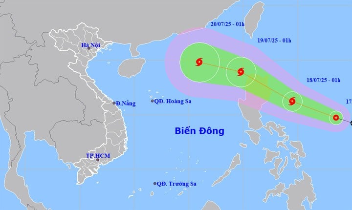
At around 1am on July 19, the storm was in the eastern sea of the North East Sea. This will be the third storm in 2025 to be active in the East Sea. Storm No. 3 moves northwest at a speed of 20-25 km/h and may strengthen. The strongest wind near the storm's center is level 10, gusting to level 12.
From the next 48 to 72 hours, storm No. 3 will move mainly in the West Northwest direction, traveling 15-20km per hour, and is likely to continue to strengthen.
Weather forecast for the whole country in the next 10 days
From July 17 to 18, heat waves continue to occur in the North, the area from Thanh Hoa to Da Nang and the eastern provinces from Quang Ngai to Dak Lak, with some places experiencing severe heat. The highest temperature ranges from 35-38°C, with some places above 38°C.
Specifically, on July 17, the area from Thanh Hoa to Da Nang and the eastern provinces from Quang Ngai to Dak Lak , the highest temperature is 35-37°C, some places over 37°C. The hot weather lasts from 11am to 4pm.
In the North, the highest temperature is commonly 35-36°C, with some places above 36°C. The hot weather lasts from 11am to 4pm.
On July 18, the heat wave increased in intensity in the above areas, with the highest temperature commonly ranging from 35-38°C, and in some places above 38°C. The humidity in the air was low, around 50-55%, further increasing the feeling of stuffiness and dryness. The heat wave lasted from 10am to 5pm.
Although it is hot and sunny during the day, showers and thunderstorms may occur in some areas in the evening and at night. Thunderstorms carry the risk of dangerous weather phenomena such as tornadoes, lightning, hail and strong winds.
From July 19, the heat in the North is likely to ease. In the Central region, the heat may last until around July 19 and begin to decrease from July 20.
In the next 24-48 hours, the Central Highlands and the South will have scattered showers and thunderstorms, locally heavy to very heavy rain, concentrated in the afternoon and evening.
According to the weather forecast from the night of July 18 to July 26, the meteorological agency said that right after the widespread heat wave, from July 20-25, the North, Thanh Hoa, and Nghe An are likely to experience widespread heavy rain, with the risk of urban flooding, flash floods, and landslides in mountainous areas.
The Central Highlands and the South maintain the weather pattern of showers and scattered thunderstorms in the afternoon and evening, locally heavy rain.
Source: https://baolangson.vn/du-bao-thoi-tiet-10-ngay-toi-mien-bac-mua-xoi-xa-tu-cuoi-tuan-5053479.html


![[Photo] National Assembly Chairman Tran Thanh Man visits Vietnamese Heroic Mother Ta Thi Tran](https://vphoto.vietnam.vn/thumb/1200x675/vietnam/resource/IMAGE/2025/7/20/765c0bd057dd44ad83ab89fe0255b783)


Comment (0)