
Meanwhile, floods on rivers from Hue city to Quang Ngai will rise and stay below alert level 3.
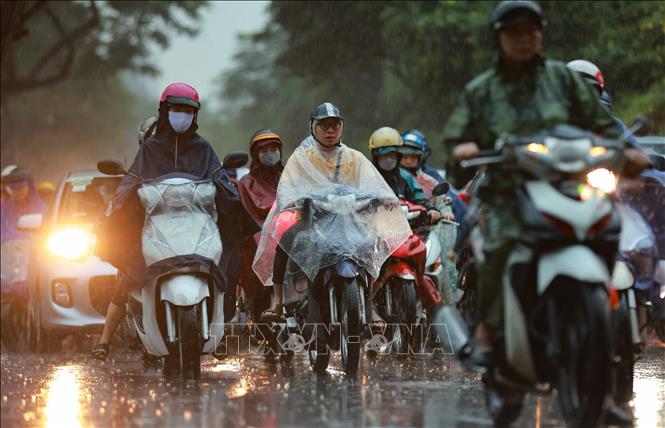
It is forecasted that in the afternoon and evening of November 2, cold air will affect the Northeast region. After that, the cold air will continue to strengthen, expanding its influence to the Northwest, North Central and some places in the Central Central region. On land, strong Northeast winds will be at level 2-3, and coastal areas will be at level 3-4.
Due to the influence of strengthening cold air, from the night of November 2-4, the North, Thanh Hoa and Nghe An will have rain, locally moderate rain.
From the night of November 2-4, the weather in the Northeast and Thanh Hoa will turn cold, with some mountainous areas experiencing severe cold. The Northwest and Nghe An will be cold, with the night of November 3-4. The lowest temperature during this cold spell in the North, Thanh Hoa and Nghe An will generally be between 16-19 degrees Celsius, with some mountainous areas below 15 degrees Celsius.
Hanoi area from the night of November 2-4 will have rain and cold weather. The lowest temperature in this cold air mass is commonly 17-19 degrees Celsius.
Cold weather can affect livestock and poultry and the growth and development of crops.
Due to the influence of cold air strengthening combined with disturbances in the upper easterly wind zone, the area from Ha Tinh to Quang Ngai continues to have widespread heavy rain.
It is forecasted that from the evening of November 1 to the evening of November 3, the area from Ha Tinh to Da Nang and the East of Quang Ngai province will have heavy to very heavy rain with rainfall in the Hue, Da Nang and East of Quang Ngai province generally 300-500mm, locally over 750mm; in the Ha Tinh and Quang Tri areas generally 200-350mm, locally over 500mm; the South of Nghe An province and the West of Quang Ngai will have moderate to heavy rain with rainfall generally 70-150mm, locally over 250mm. Warning of the risk of heavy rain (over 150mm/3 hours).
From the night of November 1 to the evening of November 2, the eastern part of Gia Lai province will have moderate to heavy rain with common rainfall of 40-80mm, locally very heavy rain of over 150mm. Warning of the risk of heavy rain (over 80mm/3 hours).
In addition, on the night of November 1 and November 2, in the West of Gia Lai province, Dak Lak to Lam Dong and the South, there will be scattered showers and thunderstorms with rainfall of 10-30mm, locally heavy rain over 70mm. During thunderstorms, there is a possibility of tornadoes, lightning, hail and strong gusts of wind. Warning of the risk of heavy rain (over 70mm/3 hours).
Warning level of natural disaster risk due to heavy rain, tornado, lightning, hail: level 1; especially in the area from Ha Tinh to Da Nang City and the East of Quang Ngai: level 2.
At sea, from the afternoon and night of November 2, in the Gulf of Tonkin, the Northeast wind will gradually increase to level 6, sometimes level 7, gusting to level 8, rough seas, waves 2-3.5m high; in the North East Sea, there will be strong Northeast wind of level 6-7, gusting to level 8-9, rough seas, waves 3-5m high.
In addition, on the night of November 1 and 2, in the southern area of the Gulf of Tonkin, the sea area from Quang Tri to Ca Mau, from Ca Mau to An Giang , the Gulf of Thailand, the northern and central areas of the East Sea (including the Hoang Sa special zone), there will be scattered showers and thunderstorms. During the thunderstorms, there is a possibility of tornadoes, strong gusts of wind of level 6-7 and waves over 2m high.
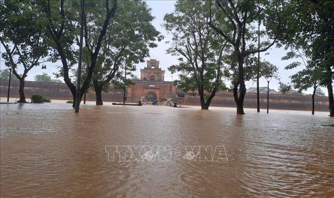
Floods on rivers from Hue to Quang Ngai
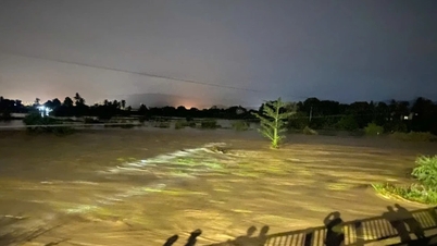
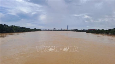
Currently, floods on rivers in Ha Tinh, Vu Gia - Thu Bon River (Da Nang), Tra Khuc River (Quang Ngai) are rising; on rivers in Quang Tri, Hue city there are fluctuations. At 2:00 p.m. on November 1, water levels on some rivers are as follows: On Huong River at Kim Long station (Hue) is 2.52m, 0.52m above alert level 2; on Bo River (Hue) at Phu Oc station is 3.71m, 0.71m above alert level 2; on Vu Gia River (Da Nang) at Ai Nghia station is 8.03m, 0.03m above alert level 2; on Thu Bon River (Da Nang) at Cau Lau station is 2.67m, 0.33m below alert level 2; on Tra Khuc River at Tra Khuc station is 5.25m, 0.25m above alert level 2.
It is forecasted that in the next 12 hours, floods on Huong, Bo and Tra Khuc rivers will continue to fluctuate and be at alert level 2 to above alert level 2; floods on Vu Gia - Thu Bon rivers will rise to alert level 2 and above alert level 2 by 0.2-0.4m.
In the next 24 hours, floods on rivers from Hue city to Quang Ngai will rise and be below alert level 3 by 0.3-0.5m.
From now (November 1) to November 5, there will be a flood on rivers in Ha Tinh and Quang Tri. During this flood, the peak water level on Ngan Sau and Ngan Pho rivers (Ha Tinh), Gianh, Kien Giang, and Thach Han rivers (Quang Tri) will rise to alert level 2-3, with some rivers rising above alert level 3.
Warning of flood risk in low-lying areas along rivers, urban areas, and densely populated areas in provinces from Ha Tinh to Quang Ngai. High risk of flash floods on rivers and streams and landslides on slopes in provinces/cities from Ha Tinh to Quang Ngai. Warning level of flood risk: Level 2.
Specific weather in each region on the night of November 1 and November 2
In the Northwest, the sky is cloudy with scattered rain. It is cold, and some places are freezing. The lowest temperature is generally 19-21 degrees Celsius, some places below 18 degrees Celsius; the highest is 22-25 degrees Celsius, some places above 25 degrees Celsius.
The Northeast has scattered rain. Northeast wind level 2-3, coastal areas level 3. Cold weather, some mountainous areas are cold. Lowest temperature from 19-21 degrees Celsius, some mountainous areas below 18 degrees Celsius; highest from 21-24 degrees Celsius.
The area from Thanh Hoa to Hue is cloudy, the North (including Thanh Hoa and Northern Nghe An) has scattered rain; the South has showers and scattered thunderstorms, locally heavy rain. Particularly from Ha Tinh to Hue, there is heavy to very heavy rain and thunderstorms in some places. The North to Northwest wind is level 2-3, the North is cold. During thunderstorms, there is a possibility of tornadoes, lightning and strong gusts. The lowest temperature is 21-24 degrees Celsius, the highest is 23-26 degrees Celsius.
In the South Central Coast, the North has heavy to very heavy rain and thunderstorms; the South has scattered showers and thunderstorms, locally heavy rain. East to Northeast wind level 2-3. During thunderstorms, there is a possibility of tornadoes, lightning and strong gusts of wind. The lowest temperature is 22-25 degrees Celsius; the highest in the North is 25-28 degrees Celsius, in the South is 29-32 degrees Celsius, some places are over 32 degrees Celsius.
The Central Highlands region also has scattered showers and thunderstorms, with some places having heavy rain. Light wind. During thunderstorms, there is a possibility of tornadoes, lightning, hail and strong gusts of wind. Lowest temperature 18-21 degrees Celsius, highest 24-27 degrees Celsius.
The South is cloudy with scattered showers and thunderstorms, with some heavy rain in some places. West to Southwest wind level 2-3. During thunderstorms, there is a possibility of tornadoes, lightning, hail and strong gusts of wind. Lowest temperature 23-26 degrees Celsius, highest 30-33 degrees Celsius.
Hanoi area has scattered rain. Northeast wind level 2-3, cold weather. Lowest temperature from 19-21 degrees Celsius, highest from 22-24 degrees Celsius.
In Ho Chi Minh City, the weather is cloudy with scattered showers and thunderstorms, with heavy rain in some places. West to Southwest wind level 2-3. During thunderstorms, there is a possibility of tornadoes, lightning, hail and strong gusts of wind. The lowest temperature is 24-26 degrees Celsius, the highest is 30-32 degrees Celsius.
Source: https://baotintuc.vn/van-de-quan-tam/khong-khi-lanh-mo-rong-vung-anh-huong-lu-tren-cac-song-tu-hue-den-quang-ngai-se-len-20251101190903211.htm


![[Photo] Prime Minister Pham Minh Chinh chairs the second meeting of the Steering Committee on private economic development.](https://vphoto.vietnam.vn/thumb/1200x675/vietnam/resource/IMAGE/2025/11/01/1762006716873_dsc-9145-jpg.webp)


Comment (0)