

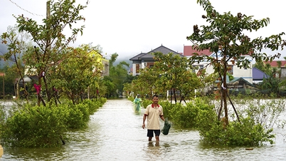
Flood in Hoi An ( Da Nang ) in late October 2025 - Photo: BD
According to the National Center for Hydro-Meteorological Forecasting, from last night to today (November 1), from Ha Tinh to Da Nang, the east of Quang Ngai will have moderate rain, heavy rain, and locally very heavy rain and thunderstorms.
Some places with heavy rain such as Ha Tinh 286mm, Thach Xuan (Ha Tinh) 268mm, Son Trach ( Quang Tri ) 233mm, Phong Nha (Quang Tri) 211mm, Binh Dien (Hue) 166mm, Rao Trang Hydroelectric Dam (Hue) 154mm, Tra Kot (Da Nang) 277mm, Phuoc Hiep (Da Nang) 226mm, Tra My (Da Nang) 208mm, Nghia Trung (Quang Ngai) 367mm, Tra Hiep (Quang Ngai) 310mm, Tra Khuc (Quang Ngai) 268mm...
The cause of this heavy rain is the influence of cold air combined with the tropical convergence zone connecting with a low pressure area in the central East Sea. In the upper atmosphere at an altitude of 1,500-5,000m, there is a strong humid easterly wind zone.
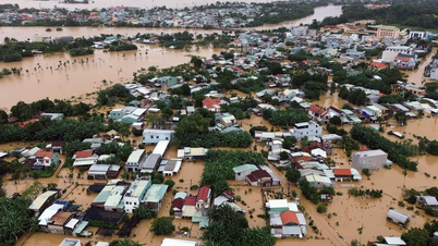
Due to heavy rain, today floods on rivers from Quang Tri to Quang Ngai tend to rise again. Currently, the water level on Gianh River (Quang Tri) is above alert level 1.
On Bo River, Huong River (Hue City) is above level 2. On Vu Gia River, Thu Bon River (Da Nang) is fluctuating at level 1 - 2. On Tra Khuc River (Quang Ngai) is at level 2.
Forecast of flood situation in the Central provinces from November 1 to 4.
It is forecasted that during the period from November 1 to 3, cold air will continuously strengthen, combined with the tropical convergence zone with an axis passing through the South Central region (connected with the low pressure area in the southern East Sea), and the east wind zone in the atmospheric layers from 1,500-5,000m will continue to operate strongly.
It is forecasted that from now (November 1) to November 4, the area from Ha Tinh to Da Nang and the east of Quang Ngai province will have heavy to very heavy rain.
Rainfall in Hue, Da Nang and eastern Quang Ngai province is generally 300-600mm, locally over 800mm.
In Ha Tinh and Quang Tri areas, rainfall is generally 200-350mm, locally over 500mm. In the south of Nghe An province and the west of Quang Ngai, there is moderate to heavy rain with rainfall generally 70-150mm, locally over 250mm.
Due to the impact of heavy rain, from November 2 to 5, floods appeared on rivers from Ha Tinh to Quang Ngai and Dak Lak.
Flood peak on rivers in Ha Tinh: Ngan Sau and Ngan Pho rivers reached level BĐ2-BĐ3.
- Quang Tri: Gianh River rises to level 2-3; Kien Giang River and Thach Han River rise to level 2-3 and above level 3.
- Hue City: Bo River and Huong River rise to level 3 and above.
- Da Nang City: Vu Gia Thu Bon River rises to level 2-3 and above level 3
- Quang Ngai: Tra Khuc and Ve rivers rise to level 2-3 and above level 3, Se San river rises to level 1-2.
- Small rivers, upstream rivers in Gia Lai, Dak Lak, Khanh Hoa rise to level BĐ1-BĐ2 and above BĐ2.
There is a high risk of flash floods on small rivers and streams, landslides on steep slopes in mountainous areas from Ha Tinh to Quang Gia Lai provinces, especially in the following provinces/cities: Ha Tinh, Quang Tri, Hue City, Da Nang City and Quang Ngai.
Of which, Ha Tinh has 47 communes/wards; Quang Tri 30 communes/wards; Hue City 19 communes/wards; Da Nang City 62 communes/wards; Quang Ngai 52 communes/wards, Gia Lai 36 communes/wards with very high risk of flash floods and landslides.
Source: https://tuoitre.vn/mien-trung-lai-mua-lon-hue-da-nang-co-noi-tren-800mm-kha-nang-xuat-hien-lu-lon-20251101181808115.htm


![[Photo] Prime Minister Pham Minh Chinh chairs the second meeting of the Steering Committee on private economic development.](https://vphoto.vietnam.vn/thumb/1200x675/vietnam/resource/IMAGE/2025/11/01/1762006716873_dsc-9145-jpg.webp)


Comment (0)