

Not only setting records in terms of quantity, this year’s storm and flood season recorded particularly unusual developments. When storms and tropical depressions appeared one after another, bringing with them heavy rains, they caused a series of consecutive natural disasters, with almost no break long enough to overcome the consequences.
Typically, in the 2 months from September to the first half of November, the East Sea was continuously hit by 8 storms and 1 tropical depression. The seasonal pattern was also completely reversed when a storm arrived at a record early date in June (storm No. 1) - the earliest storm to appear in the East Sea in the past 40 years. Also in 10 months, the whole country recorded many extreme heavy rains and floods exceeding history on 13 rivers in the Northern and Central regions.
Towards the end of the season, the floods become more frequent and unusual. During October and November, many provinces in the Central region struggled to endure many large floods, one flood had just receded when another one came. Typically, the floods in the South Central region from November 16 to 22 were an extreme phenomenon, surpassing historical records.
Rainfall at many stations such as Son Hoa ( Dak Lak ) 601.2 mm or Quy Nhon (Gia Lai) 380.6 mm all exceeded previous records. Meanwhile, some other stations such as Son Thanh Tay, Son Thanh Dong, Hoa My Tay, Song Hinh recorded up to 1,000 - 1,200 mm in just a few days.
According to the classification of the World Meteorological Organization (WMO), these are rare events, almost impossible to predict accurately quantitatively. According to statistics over the past 30 years, major floods in the South Central region often occur before November 15, however, the major flood in 2025 appears later than this rule.
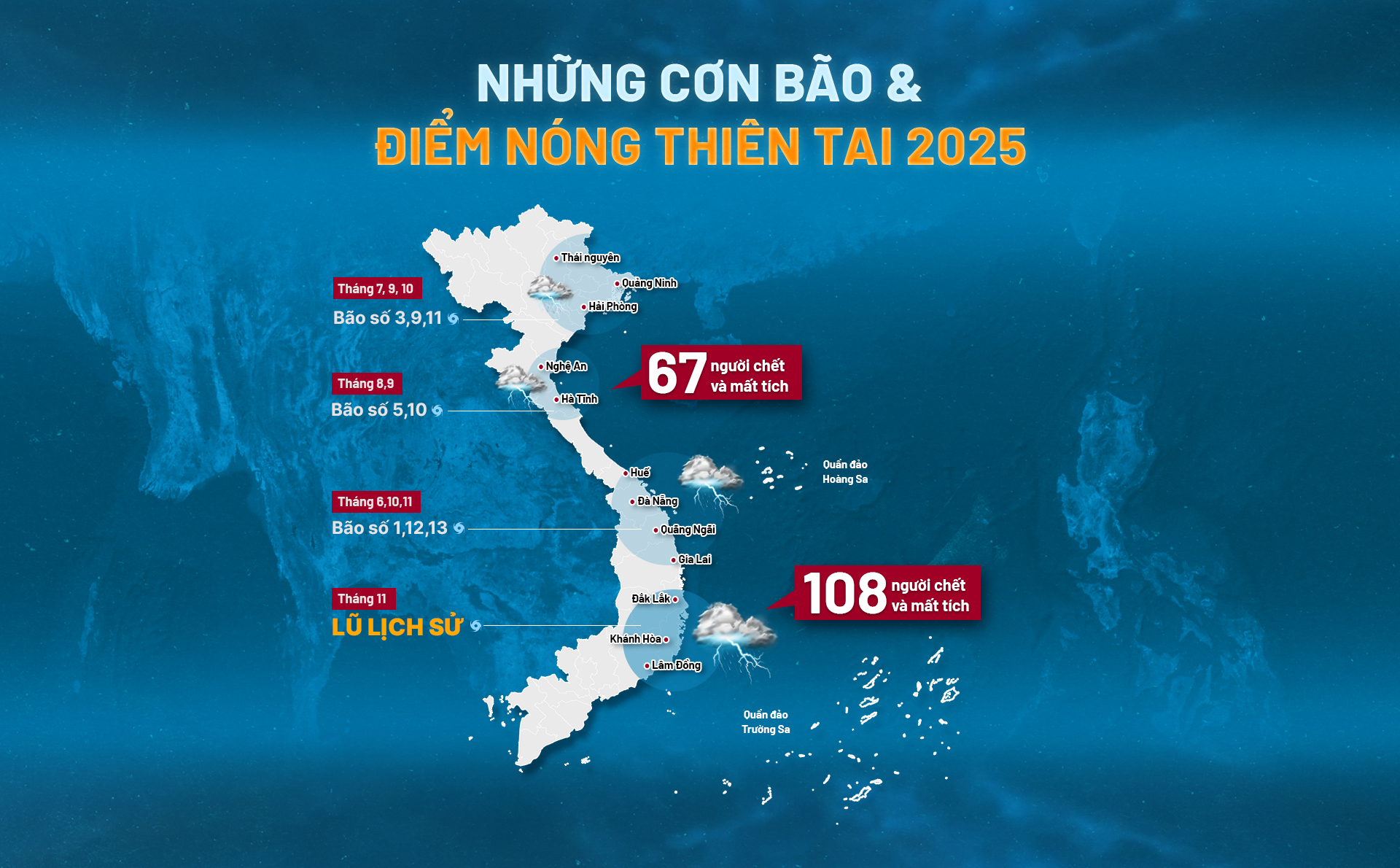
According to the Department of Dyke Management and Natural Disaster Prevention (Ministry of Agriculture and Environment), as of November 24, storm after storm, flood after flood caused severe damage, leaving 409 people dead and missing, 727 injured, and more than 337,000 houses collapsed or damaged. Total accumulated economic damage is estimated at over VND85,099 billion.
As of November 24, storms, floods, and tornadoes have caused heavy human losses, leaving 409 people dead and missing ; of which 108 people were killed in the recent Central region floods.
![]()
After the first 11 months of 2025, storms, floods, and tornadoes have caused total estimated economic damage of over VND 85,099 billion to localities across the country.
![]()


The most frightening thing about the 2025 hurricane season is not just the number, but the appearance of storms with extremely unique characteristics, challenging all prevention scenarios and causing a series of huge cumulative damages.
Below is a detailed profile of typical storms and floods, showing the terrible devastation of this year's natural disasters:

Storm No. 1 (Wutip) arrives unusually early (June 11-14)
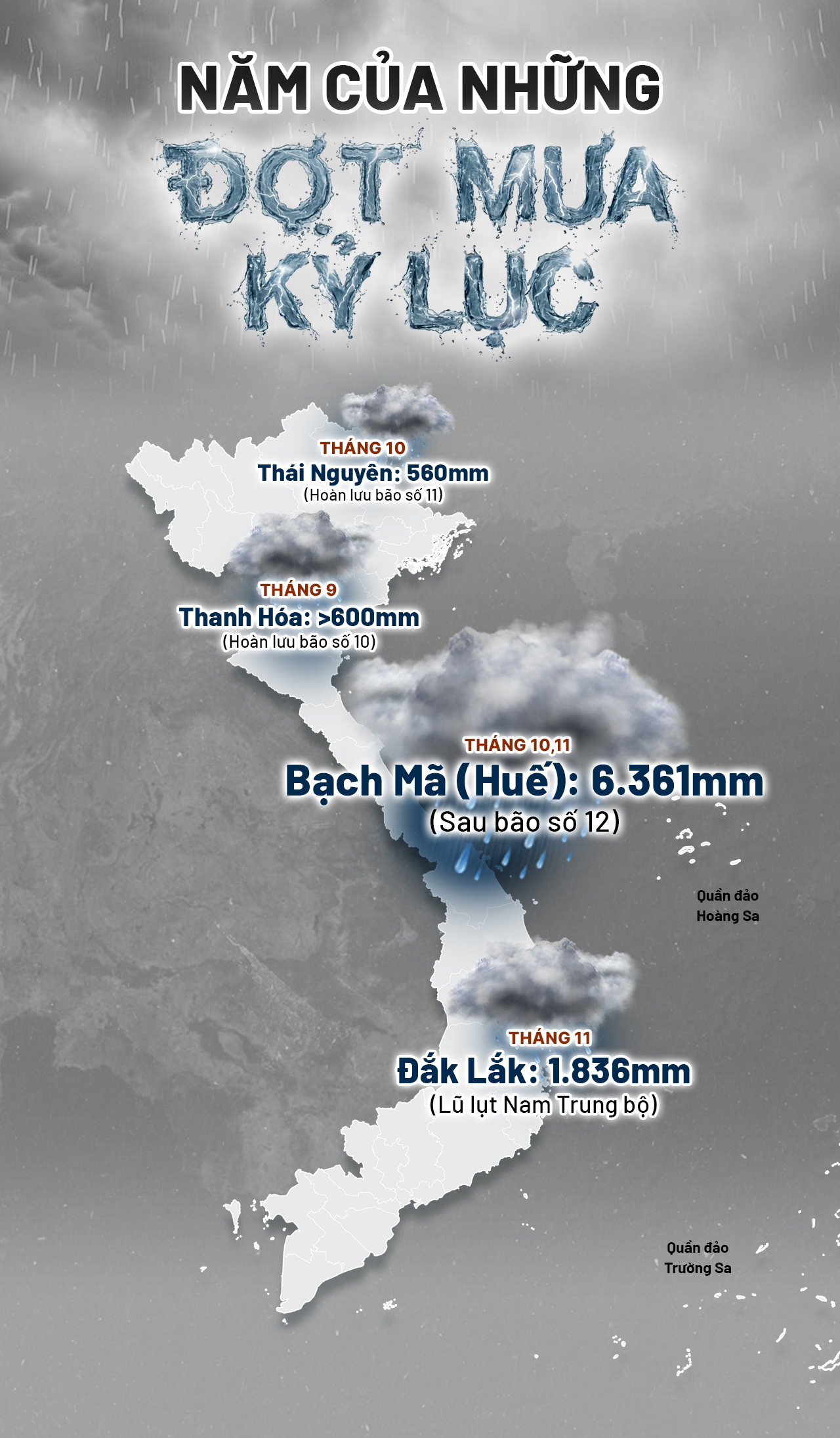
Development: The storm appeared earliest in over 40 years. Unusually, in the middle of the dry season, the storm's circulation dumped 1,277 mm of rain on Bach Ma (Hue City). The flood peak in Quang Tri and Hue exceeded alert level 3, the highest in June in the past 30 years.
Damage: Storm and flood killed 7 people, flooded and damaged more than 4,300 houses; more than 76,000 hectares of rice were flooded. Economic damage was 1,317 billion VND.
Ha Long Bay storm tragedy (July 19)
Development: On the afternoon of July 19, 2025, one of the most heartbreaking tragedies in the history of waterway tourism occurred when the ship Vinh Xanh 58 was suddenly overturned by a storm in Ha Long Bay.
Damage: A tragic waterway accident killed 39 people.
Storm No. 3 (Wipha) - Reservoir flooding exceeds design (July 19-23)
Development: Storm No. 3 landed in Hung Yen - Ninh Binh with level 9, gusting to level 11. Circulation caused heavy rain of 200 - 350 mm in Thanh Hoa, Nghe An, pushing the upstream flood of Ca River beyond history. In particular, the flow to Ban Ve Lake reached 12,800 m³/s (far exceeding the test flood of 10,500 m³/s).
Damage: Floods after the storm killed 4 people and damaged nearly 8,000 houses. Economic damage was 4,602 billion VND.
Flash floods and landslides in the Northwest (late July - August 1)
Developments: Continuous heavy rains caused two particularly large floods on the upper reaches of the Ma River (Son La), approaching the historic milestone of 1975. On August 1, serious flash floods and landslides occurred in the old Dien Bien Dong.
Damage: Floods and landslides killed 16 people (10 in Dien Bien Dong alone), 3,389 houses were flooded and damaged; damage of more than 2,200 billion VND.
Adolescent

Storm No. 5 (Kajiki, August 25)
Development: Rapidly increasing to level 14 at sea. Landing in Nghe An - Ha Tinh on August 25 with winds of level 11-12. Storm circulation causes heavy rain in Thanh Hoa - Ha Tinh area from 200 - 450 mm and the North. Floods on 5 major rivers (Ma, Len, Day, Hoang Long, Tich) simultaneously exceed alert level 3, causing serious flooding in urban areas.
Damage: The storm and subsequent floods killed 9 people and damaged/roofed more than 46,000 houses. Economic damage was 6,141 billion VND.
Super typhoon No. 9 (Ragasa, September 22-24)
Development: The strongest in the history of the East Sea, reaching level 17, gusting above level 17, surpassing even super typhoon Yagi (2024). For the first time, the meteorological agency had to use the final level - level 17 on the Bo-pho typhoon wind scale. This terrible wind force was maintained when the storm entered the northern East Sea on the evening of September 22. Although it weakened quickly upon landfall due to terrain friction, the storm's circulation still caused heavy rain of 100 - 250 mm in Quang Ninh and Thanh Hoa.
Damage: Due to rapid weakening, damage was mainly to property with 21 houses having their roofs blown off, 142 hectares of rice crops flooded in Quang Ninh; some schools and roads were eroded.
Adolescent
Storm No. 10 (Bualoi, September 28-29)
Development: Appearing right after storm No. 9, storm No. 10 moved at an unusually terrible speed of 30 - 35 km/h (twice as fast as a normal storm). The abnormality lies in the area of influence: the storm's center hit Ha Tinh - Quang Tri, but the wide circulation caused thunderstorms all the way to the North. In particular, the storm stayed on land for a record 12 hours, causing widespread rain of 300 - 600 mm; flooding, flash floods, and landslides.
Damage: One of the most devastating storms with 67 dead and missing, 184 injured; 443 houses collapsed; nearly 200,000 houses damaged. Total record damage: 23,898 billion VND.

Storm No. 11 (Matmo, October 2-7)
Developments: Just a few days after storm No. 10, storm Matmo appeared. Although it quickly dissipated at the Vietnam - China border on October 6, the circulation dumped "water bombs" on the Northeast and Hanoi; especially in Thai Nguyen (in some places 560 mm). 9 hydrological stations on 5 rivers (Cau, Thuong, Ca Lo, Trung, Bang) simultaneously overcame historic floods.
Damage: Floods after the storm left 18 people dead/missing, 16 injured; 2,014 houses damaged; nearly 242,500 houses flooded. Economic damage was about 19,508 billion VND.
Storm No. 12 (Fengshen, October 19 - November 3)
Development: About a week after storm No. 11, storm No. 12 (Fengshen) formed. The storm circulation combined with cold air caused an unimaginable amount of rain. In Bach Ma (Hue), the total rainfall reached 6,361 mm, with 1,740 mm on October 27 alone - approaching the world record for daily rainfall (1,825 mm in the Indian Ocean in 1966). Floods on the Bo River (Hue) and Thu Bon River (Da Nang) broke all historical records.
Damage: Severe consequences with 55 people dead/missing; over 800 houses damaged, collapsed, swept away; nearly 160,000 houses flooded; damage of 7,250 billion VND.
Adolescent
Storm No. 13 (Kalmaegi, November 5-6)
Development: In early November, storm No. 13 appeared with the ability to rapidly increase in intensity: from level 13 to level 15 in just 1 day. The storm made landfall in Quang Ngai - Gia Lai. Circulation caused heavy rain from Hue - Dak Lak (generally 150 - 280 mm, locally 504 mm). Floods on Ba River and Ky Lo River (Gia Lai, Dak Lak) simultaneously exceeded alert level 3.
Damage: 6 people died, 39 people were injured; more than 1,200 houses collapsed; more than 67,000 houses were damaged, roofs were blown off; 21,134 houses were flooded; 524 ships were sunk or damaged by waves... Economic damage was about 8,824 billion VND.
Historic floods in the South Central region (November 16-20)
Development: No storm, but the intensity of rain is terrible. Floods on rivers appear in a "rolling" form, continuously breaking records. In Dak Lak, many places recorded rainfall of 1,000 - 1,200 mm, with Song Hinh reaching 1,861.8 mm. Song Ba and Song Dinh exceeded the historical floods of 1993 and 1986 by more than 1 meter. Song Ba Ha Hydropower Plant had to discharge floodwaters at a "terrifying" flow rate of 16,100 m³/second.
Damage: The year's deadliest natural disaster with 108 dead and missing (63 in Dak Lak alone); more than 272,000 houses flooded. Preliminary economic damage of 14,352 billion VND.
Storm No. 15 (Koto) and tropical depression (forecast November 28 - December 2)
Current situation: While the people of the South Central region have not yet recovered from the floods, storm No. 15 (Koto) with a strength of level 10, gusting to level 13, has appeared again, targeting this area. The storm moves at a "snail" speed of 5 km/h but is very unpredictable, changing direction 6 times, putting great pressure on forecasting work.
Currently, due to the weakened circulation of the low pressure area from storm No. 15 in the upper atmosphere being a disturbance in the easterly wind zone, it is forecasted that from the night of December 2 to December 5, from Quang Tri to Da Nang, the eastern provinces from Quang Ngai to Dak Lak and Khanh Hoa will have moderate rain, widespread heavy rain, with rainfall in some places exceeding 250 mm; warning of heavy rain over 100 mm/3 hours.
Army, police and youth forces support clean-up and flood recovery in Dak Lak and Khanh Hoa
Adolescent

According to the National Center for Hydro-Meteorological Forecasting, climate change is causing storms to no longer follow previous rules. Storms form early and in succession in the East Sea. In particular, storm circulation and extreme weather combinations cause very heavy rains.
Most recently, the flood from November 15 to 21 was the result of a combination of many extreme weather patterns. At high altitudes, disturbances in the East wind zone at altitudes from 1,500 to 5,000 m were active, combined with very strong cold air, especially from the night of November 17, creating a zone of humidity convergence from low to high altitudes.
Water vapor from the East Sea is continuously transported to the mainland of the Central and Central Highlands, while the Truong Son terrain acts as a "windbreak", stimulating convection to develop strongly and maintain prolonged rain. Rainfall ranges from 8,000 to 1,700 mm in many places, far exceeding the natural drainage capacity.
In addition to weather factors, the topographical and hydrological characteristics of the Central region also increase the risk of major floods. Short river basins and steep slopes cause rainwater to concentrate quickly downstream, leading to flash floods, flash floods and floods that rise rapidly within just a few hours, combined with high tides, causing slow drainage.
According to the National Center for Hydro-Meteorological Forecasting, climate change has made extreme rainfall patterns stronger and more difficult to predict, while increasing the frequency of major floods in the past 10-15 years, with many stations recording rainfall exceeding historical levels of 1,000-1,700 mm/period.
Mr. Hoang Phuc Lam, Deputy Director of the National Center for Hydro-Meteorological Forecasting, warned that this year's storm season may not end. It is forecasted that from now until the end of 2025 and early 2026, the East Sea will still have the possibility of 1-2 more storms and tropical depressions, focusing on the South Central region and southward.
Heavy rains will continue to threaten the Central region until the first half of December. It is forecasted that from December 2025 to February 2026, the North will experience widespread cold spells. Furthermore, during the dry season of 2026, the South Central and South regions may experience unseasonal rains, continuing the series of unpredictable weather days.
The year 2025 is indeed a strong warning from nature, when records are no longer the limit, forcing disaster response thinking to shift to a new mindset.
That is to immediately review the current situation, overcome limitations and always be ready for the most unusual scenarios.

Thanhnien.vn
Source: https://thanhnien.vn/nam-bao-lu-di-thuong-khoc-liet-185251201204949485.htm

![[Photo] Worshiping the Tuyet Son statue - a nearly 400-year-old treasure at Keo Pagoda](/_next/image?url=https%3A%2F%2Fvphoto.vietnam.vn%2Fthumb%2F1200x675%2Fvietnam%2Fresource%2FIMAGE%2F2025%2F12%2F02%2F1764679323086_ndo_br_tempimageomw0hi-4884-jpg.webp&w=3840&q=75)
![[Photo] Parade to celebrate the 50th anniversary of Laos' National Day](/_next/image?url=https%3A%2F%2Fvphoto.vietnam.vn%2Fthumb%2F1200x675%2Fvietnam%2Fresource%2FIMAGE%2F2025%2F12%2F02%2F1764691918289_ndo_br_0-jpg.webp&w=3840&q=75)


Comment (0)