
")
This afternoon, July 20, the Department of Dyke Management and Natural Disaster Prevention ( Ministry of Agriculture and Environment ) released storm response guidelines, helping people minimize risks to life and property.
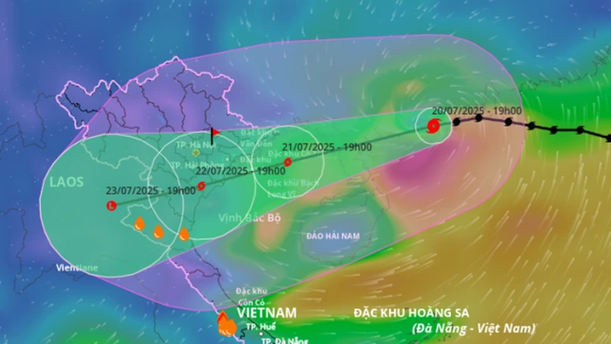
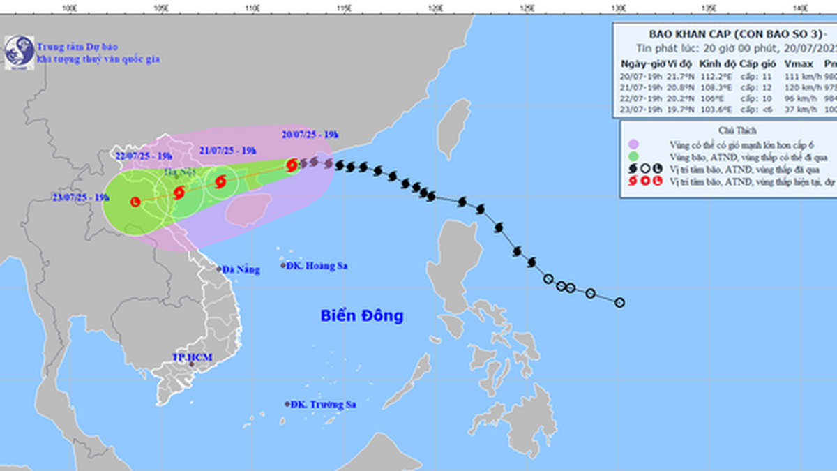
Updated at 1:00 p.m. on July 20 from the National Center for Hydro-Meteorological Forecasting, the center of storm No. 3 has moved to coordinates of about 21.9 degrees North latitude - 113.4 degrees East longitude, about 563km from Mong Cai ( Quang Ninh ). The strongest wind near the center of the storm is level 12, gusting to level 15. In the next 3 hours, the storm will continue to move west at a speed of about 25km/hour.

According to the Department of Dyke Management and Natural Disaster Prevention, people should absolutely not be subjective. Below are 11 specific recommendations that need to be strictly implemented:
- - Regular monitoring: Update storm forecasts and natural disaster warnings from official sources for proactive prevention.
- - Protect boats and people at sea: Ensure safety at anchorages; absolutely do not stay on boats, watchtowers, cages, or aquaculture areas when a storm hits.
- - Travel restrictions: Cancel travel plans if the weather is bad; avoid coastal areas, islands, and mountainous areas at risk of landslides. Do not go out when a storm hits except in an emergency.
- - Safe shelter: Choose a secure shelter; evacuate proactively if necessary or as ordered by local authorities.
- - Stock up on essential supplies: Including food, water, and medicine for at least 3 days.
- - House reinforcement: Tree trimming, billboard removal, ventilation holes sealing, ensuring construction safety.
- - Agricultural response: Reinforce barns; take advantage of harvest according to the motto "green at home is better than ripe in the fields".
- - Flood prevention: Be alert for urban flooding, flash floods in mountainous areas; rising water in coastal areas and river mouths.
- - Protect property: Keep furniture high, store important documents, move the vehicle to a high place.
- - Clear sewers: Keep flood drainage clear; do not park in low-lying areas, especially near apartment basements.
- - Save emergency phone numbers: Rescue, local authorities for support when needed.

Along with that, the Department of Dyke Management and Disaster Prevention also guides safety skills before and during storms:
Before the storm:
- Charge communication devices, flashlights, power banks.
- Fill up with gas, ready for emergency travel.
- Elevate property, check garage.
- If the house is not safe, evacuate to another place immediately when requested.
During the storm:
- Stay home, don't go out.
- Be careful with objects that can be blown away by the wind.
- Do not take shelter under trees or electric poles.
- Remember: before the wind changes direction to become stronger there will be about 30 minutes – 1 hour of calm.
The Disaster Prevention Agency recommends that people strictly follow the above instructions and guidance to ensure maximum safety for themselves and their families against storm No. 3 as well as other storms.

According to Mr. Hoang Phuc Lam, Deputy Director of the National Center for Hydro-Meteorological Forecasting, storm No. 3 has strengthened by 2 levels compared to 20 hours ago, reaching level 12 - the first level of a very strong storm (level 12-15).
“Today will be the strongest phase of storm No. 3. Hopefully, the storm will weaken due to interaction with the terrain of mainland Guangdong (China). The further inland the storm goes, the more likely it will weaken,” Mr. Lam shared.
Source: https://www.sggp.org.vn/nguoi-dan-nen-lam-gi-khi-bao-so-3-wipha-do-bo-post804584.html


![[Photo] National Assembly Chairman Tran Thanh Man visits Vietnamese Heroic Mother Ta Thi Tran](https://vphoto.vietnam.vn/thumb/1200x675/vietnam/resource/IMAGE/2025/7/20/765c0bd057dd44ad83ab89fe0255b783)


Comment (0)