
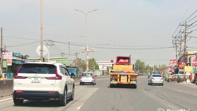
Water from canals and rivers rose and flooded low-lying roads in Ho Chi Minh City. On Nguyen Van Linh Street, below the Phu My overpass, rising water made it difficult for many drivers to move.


The water rose during rush hour, causing traffic to be congested and moving slowly. Some motorcyclists, in order to avoid deep water, drove too close to large vehicles such as trucks and tractor trailers, which could easily lead to collisions.


On the old District 7 streets such as Pham Huu Lau, Huynh Tan Phat, Phu Thuan, Tran Xuan Soan, Nguyen Luong Bang, Le Van Luong, Nguyen Thi Thap, etc., high tides from Kenh Te overflowed, causing these streets to be heavily flooded.


Ms. Tuyen, a trader at the Nguyen Luong Bang - Hoang Quoc Viet intersection, said that the flooding slowed down vehicles, causing congestion. The rising water made it impossible for people here to display their goods for sale. At Tran Xuan Soan Street, due to the proactive setting up of a "dyke" with sandbags, the flooding on this street was less severe than during previous high tides.
According to the Southern Hydrometeorological Station, the highest peak tide in the middle of the 10th lunar month falls on December 5 and 6. The tide level fluctuates between 1.7 and 1.75 meters, above alert level 3.
According to the Ho Chi Minh City Department of Construction, many wards and communes were affected by high tides, including wards such as An Khanh, Phuoc Long, Phu Huu, Tan Thuan, Tan My, Phu Thuan, Nha Be commune, Hiep Phuoc, Binh Dong ward; Binh Hung, Tan Nhut, Tan Vinh Loc, Binh Loi, Thanh Da communes; Bung Cai canal, Binh Thang stream, Binh Duong avenue, etc.
There are a total of about 23 roads flooded during high tides, of which the old Ho Chi Minh City has 12 roads; the old Binh Duong has 8 roads and the old Ba Ria Vung Tau has 3 roads.
Source: https://cand.com.vn/Giao-thong/nhieu-tuyen-duong-ngap-nang-trong-dinh-trieu-giua-thang-10-am-lich-i790296/


Comment (0)