
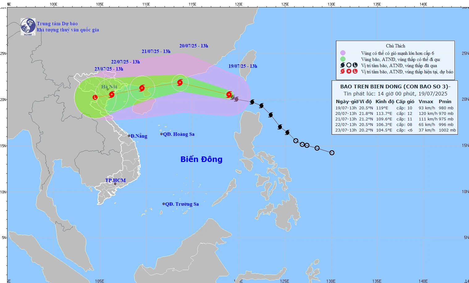
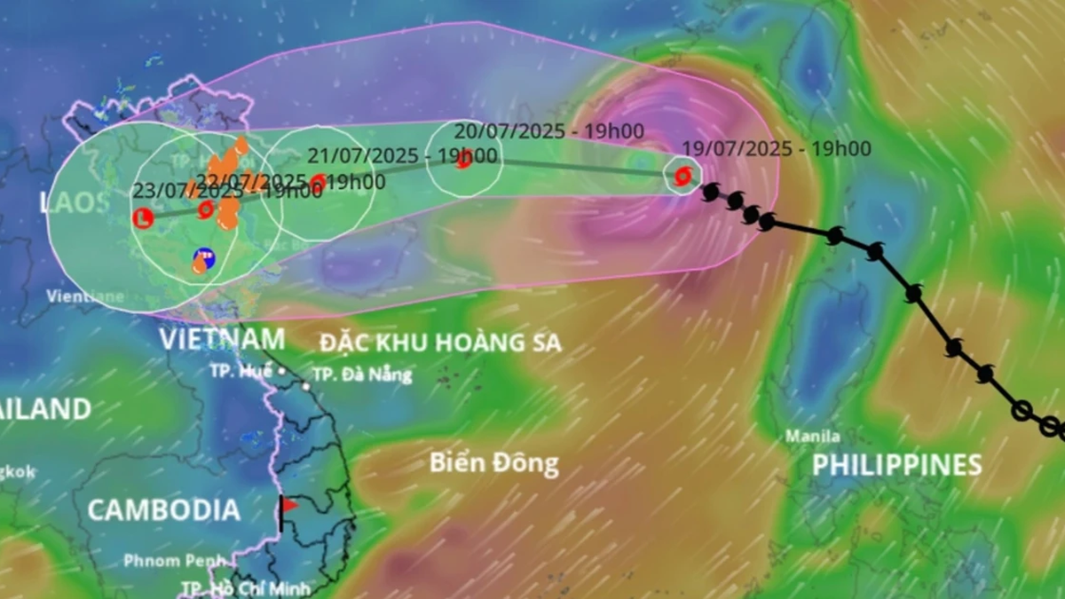
Forecast path of storm Wipha at 2:00 p.m. on July 19, 2025.
Accordingly, at 1 p.m., the center of the storm was at about 20.5 degrees North latitude, 119 degrees East longitude, in the northeastern sea area of the North East Sea. The strongest wind was level 9-10 (75-102 km/h), gusting to level 12. The storm moved northwest at a speed of about 20 km/h.
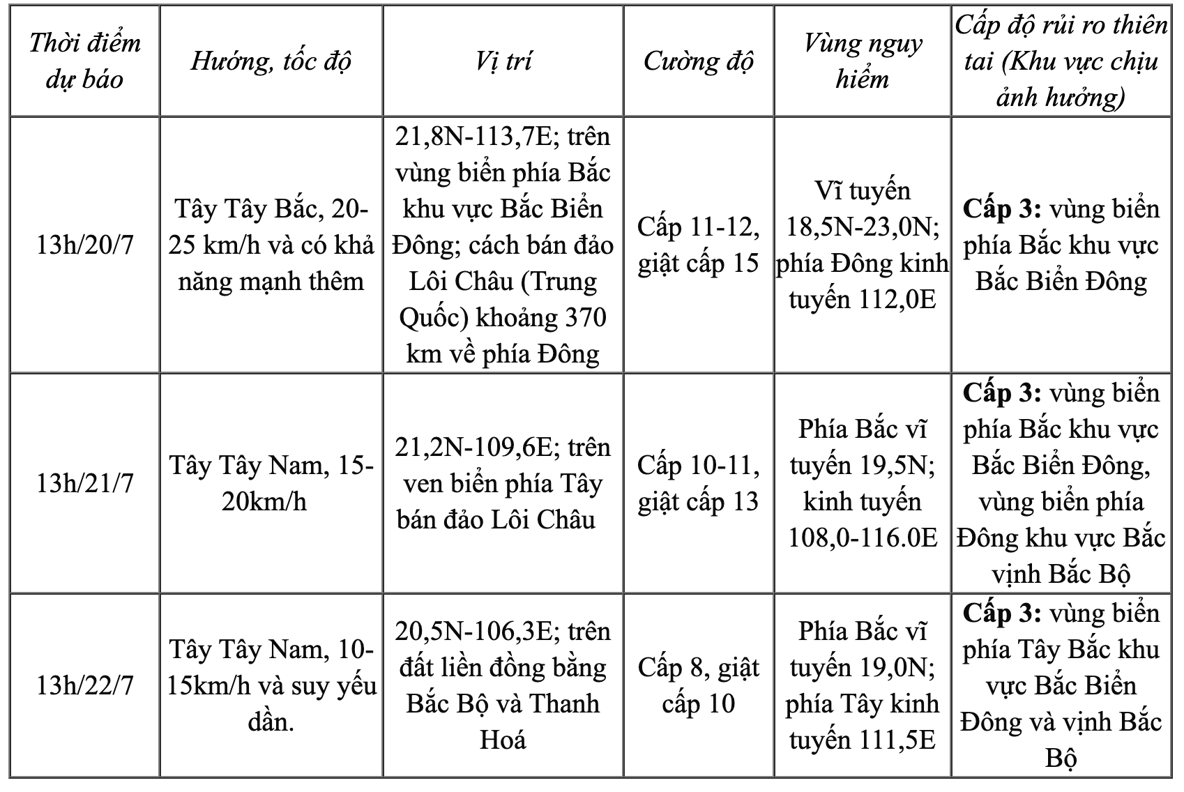
Forecast, tomorrow 13:00 July 20, the storm will move in the West Northwest direction, speed 20-25 km/h and is likely to strengthen. The center of the storm is located in the northern sea area of the North East Sea; about 370 km east of Leizhou Peninsula (China). Intensity level 11-12, gust level 15.
At 1:00 p.m. on July 21, the storm moved west-southwest at a speed of 15-20 km/h. The center of the storm was located in the coastal area west of Leizhou Peninsula (China). The intensity was level 10-11, gusting to level 13.
At 1:00 p.m. on July 22, the storm continued to move in a West-Southwest direction at a speed of 10-15 km/h and gradually weakened. At this time, the storm was located over the mainland of the Northern Delta and Thanh Hoa .
Detailed forecast of storm developments (in the next 24 to 72 hours) is as follows:
Due to the impact of the storm, the northern area of the North East Sea has strong winds of level 8-10, near the storm center level 11-12, gusting to level 15. Waves are 4-6m high. The sea is very rough.
The meteorological agency warns that ships in the danger zone are at high risk of encountering thunderstorms, tornadoes, strong winds and large waves. Northern coastal localities should proactively deploy storm prevention plans and closely monitor the next bulletins.
On the morning of July 19, the Department of Hydrometeorology ( Ministry of Agriculture and Environment ) held a meeting on the developments and impacts of storm No. 3 and the flood situation caused by the storm. According to the forecast of the National Center for Hydro-Meteorological Forecasting, on July 20-21, the special zones of Bach Long Vi, Co To, Cat Hai... are likely to be greatly affected by strong winds and heavy rains caused by storm No. 3. Around early morning and on July 22, coastal waters from Quang Ninh to Thanh Hoa will begin to experience strong winds, heavy rain, level 7 - level 9 winds, and waves 3 - 5m high. The National Center for Hydro-Meteorological Forecasting said that the scope of influence of storm No. 3 is very wide, almost the entire Northeast region, some places in the Northwest, and the North Central provinces. In particular, Quang Ninh, Hai Phong, coastal areas of Hung Yen, Ninh Binh, Thanh Hoa provinces will be the areas directly affected and most affected by the storm. | |
NDS
Source: https://baothanhhoa.vn/thanh-hoa-la-mot-trong-cac-tinh-co-kha-nang-chiu-anh-huong-truc-tiep-cua-bao-wipha-255326.htm


Comment (0)