

According to the National Center for Hydro-Meteorological Forecasting, the tropical depression has weakened into a low pressure area in the eastern sea of the North East Sea. This is the last news about the tropical depression.
In the next 12 hours, the low pressure area will weaken and gradually dissipate.
At 1:00 a.m. on October 24, the center of the low pressure area was at about 17.4 degrees North latitude; 117.5 degrees East longitude. The strongest wind in the center of the low pressure area decreased to below level 6 (below 39 km/h).
It is forecasted that in the next 12 hours, the low pressure area will continue to move mainly in the southwest direction, weakening and gradually dissipating.
Due to the influence of the weakened low pressure circulation from the tropical depression combined with the strengthening cold air, the situation of strong winds at sea is still complicated. It is necessary to pay attention to the next strong wind forecast bulletins at sea.
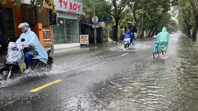
Heavy rain in many areas
The National Center for Hydro-Meteorological Forecasting said that from early morning on October 24 to the night of October 25, in the area from South Quang Tri to Quang Ngai and the East of Gia Lai province, there will be moderate rain, heavy rain and thunderstorms with common rainfall of 100-250mm, locally very heavy rain over 450mm (heavy rain concentrated in coastal areas). Warning of the risk of heavy rain over 150mm/3 hours.
In addition, on the day and night of October 24, the area from Nghe An to North Quang Tri, the East of Dak Lak province to Lam Dong and the South will have scattered showers and thunderstorms with rainfall of 15-40mm, locally heavy to very heavy rain of over 100mm. Warning of the risk of heavy rain over 60mm/3 hours.
During the day and night of October 26, the area from Quang Tri to Quang Ngai will have moderate to heavy rain and thunderstorms with rainfall ranging from 50-100mm, and locally very heavy rain of over 200mm. Heavy rain in this area is likely to last until the end of October 2025. The risk of natural disasters due to heavy rain, tornadoes, lightning, and hail is level 1.
Heavy rain can cause flooding in low-lying areas, urban and industrial areas; flash floods in small rivers and streams; and landslides on steep slopes.
"Thunderstorm areas are likely to experience tornadoes, lightning, hail and strong gusts of wind," noted Deputy Head of the Weather Forecasting Department Vu Anh Tuan.
Many sea areas have strong winds and high waves.
The National Center for Hydro-Meteorological Forecasting forecasts that on the day and night of October 24, the North East Sea area (including Hoang Sa special zone) will have strong winds of level 6-7, gusting to level 8-9; rough seas, waves 3-5m high.
The area from South Quang Tri to Quang Ngai has strong winds of level 6, gusts of level 8, rough seas, waves 2.5-4.5m high.
Gulf of Tonkin wind level 5, sometimes level 6, gust level 7-8, rough sea, waves 2-3.5m high.
In addition, on the day and night of October 24, the sea area from South Quang Tri to Ca Mau, from Ca Mau to An Giang, the Gulf of Thailand, the North and Central East Sea (including Hoang Sa special zone) and the South East Sea (including Truong Sa special zone) will have scattered showers and thunderstorms, with the possibility of tornadoes, strong gusts of wind of level 6-7 and waves over 2.0m high during thunderstorms.
On the day and night of October 25, the northern sea area of the North East Sea will have strong northeast winds of level 6, sometimes level 7, gusting to level 8-9, rough seas, waves 3-5m high.
The sea area from South Quang Tri to Quang Ngai has strong northeast wind level 6, gusting to level 7-8, rough sea, waves 2.5-4.5m high.
During the day, the Gulf of Tonkin has strong northeast winds of level 5, sometimes level 6; at night, they gradually strengthen to level 6, gusting to level 7-8, rough seas, waves 2-4m high.
Marine disaster risk level 2.
All vessels operating in the above areas are at high risk of being affected by strong winds and large waves.
Currently, at Bach Long Vi station, there are strong Northeast winds of level 6-7, gusting to level 9; at Con Co station, there are strong winds of level 6, gusting to level 8.
")
Weather in regions day and night October 24:
Northwest
- Rain in some places, early morning and night cold. Light wind.
- Lowest temperature 18-21 degrees Celsius, some places below 17 degrees Celsius. Highest temperature 24-27 degrees Celsius, some places above 27 degrees Celsius.
Northeast
- Scattered rain in the morning, then rain in some places, cold in the early morning and at night, cold during the day. Northeast wind level 2-3, coastal areas level 3-4.
- Lowest temperature 18-21 degrees Celsius, in mountainous areas some places below 17 degrees Celsius. Highest temperature 21-24 degrees Celsius, some places above 24 degrees Celsius.
Hanoi City
- Morning with occasional rain, then no rain, early morning and night cold, cold day. Northeast wind level 2-3.
- Lowest temperature 19-21 degrees Celsius. Highest temperature 22-24 degrees Celsius.
Provinces and cities from Thanh Hoa to Hue
- In the North, there is scattered rain, locally heavy rain; in the South (South Quang Tri to Hue city), there is moderate rain, heavy rain, locally very heavy rain and thunderstorms, cold early morning and night, cold during the day. North to Northwest wind level 2-3.
- Lowest temperature 18-21 degrees Celsius. Highest temperature 21-24 degrees Celsius, some places above 24 degrees Celsius.
South Central Coast
- In the North, there will be moderate to heavy rain, locally very heavy rain and thunderstorms; in the South, there will be clouds, scattered showers and thunderstorms, locally heavy to very heavy rain, with the possibility of tornadoes, lightning and strong gusts of wind. Northeast wind level 2-3.
- Lowest temperature 23-26 degrees Celsius. Highest temperature in the North 26-29 degrees Celsius, in the South 29-31 degrees Celsius.
Central Highlands
- Scattered showers and thunderstorms, locally heavy rain, with the possibility of tornadoes, lightning, hail and strong gusts of wind. Northeast wind level 2-3.
- Lowest temperature 19-22 degrees Celsius. Highest temperature 27-30 degrees Celsius, some places above 30 degrees Celsius.
Southern Vietnam
- Scattered showers and thunderstorms, locally heavy rain, with the possibility of tornadoes, lightning, hail and strong gusts of wind. Northeast to East wind level 2-3.
- Lowest temperature 23-26 degrees Celsius. Highest temperature 30-33 degrees Celsius, some places above 33 degrees Celsius.
Ho Chi Minh City
- Scattered showers and thunderstorms, locally heavy rain, with the possibility of tornadoes, lightning and strong gusts of wind. Northeast to East wind level 2-3.
- Lowest temperature 24-26 degrees Celsius. Highest temperature 31-33 degrees Celsius.
PVSource: https://baohaiphong.vn/thoi-weather-ngay-24-10-khu-vuc-bac-bo-sang-co-mua-troi-lanh-524425.html

![[Photo] Urgently help people soon have a place to live and stabilize their lives](/_next/image?url=https%3A%2F%2Fvphoto.vietnam.vn%2Fthumb%2F1200x675%2Fvietnam%2Fresource%2FIMAGE%2F2025%2F12%2F09%2F1765248230297_c-jpg.webp&w=3840&q=75)


![[Photo] General Secretary To Lam works with the Standing Committees of the 14th Party Congress Subcommittees](https://vphoto.vietnam.vn/thumb/402x226/vietnam/resource/IMAGE/2025/12/09/1765265023554_image.jpeg)


Comment (0)