
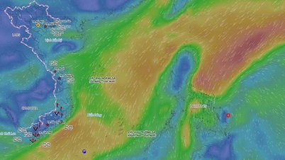
At 1:00 a.m. on December 9, the tropical depression continued to move west-southwest faster, about 20 km/h, entering the eastern sea area in the middle of the East Sea, 350 km east-southeast of Song Tu Tay Island; the dangerous area is between 10-13 degrees North latitude and east of 116.5 degrees East longitude. The disaster risk level in this area is level 3.
In the next 48-72 hours, the tropical depression is forecast to continue moving west-southwest at a speed of 20-25 km/h with little change in intensity. From the morning of December 8, the eastern sea area in the middle of the East Sea (including the sea area northeast of Truong Sa) will have winds gradually increasing to level 6, gusting to level 8; waves 2-4 m high, rough seas. Ships in the danger zone are likely to encounter thunderstorms, whirlwinds and large waves.
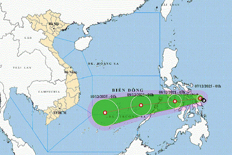
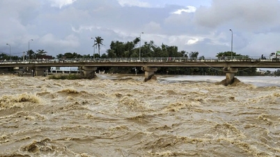
Currently, the North East Sea has strong Northeast winds of level 6, sometimes level 7; at Huyen Tran station, gusts of level 8-9 are recorded, and at Phu Quy station, gusts of level 7 are recorded. During the day and night of December 7, many sea areas continue to have strong winds: the North East Sea gradually increases to level 6-7, gusts of level 8-9, waves of 4-6 m, rough seas; the West Central East Sea, the sea area from Da Nang to Dak Lak and the area from Khanh Hoa to Ca Mau all have winds of level 6, gusts of 7-9, rough seas.
In the South China Sea (including the Truong Sa sea area), there will be scattered showers and thunderstorms, with the possibility of tornadoes and gusts of wind of level 6-7. On the day and night of December 8, strong winds will continue in most sea areas; in the East and Central China Sea, there will be winds of level 6, gusts of level 8; the risk of natural disasters at sea will be at level 2 and increase to level 3 in the area northeast of Truong Sa.
Weather forecast for regions across the country:
Hanoi capital is cloudy, with scattered light rain during the day and rain in some places at night. Northeast wind level 2-3. Cold at night and morning. Lowest temperature 17-19 degrees Celsius. Highest temperature 21-23 degrees Celsius.
The Northwestern provinces are cloudy, with scattered light rain during the day and rain at night in some places; the Northwestern region is cloudy and has rain in some places. Light wind. Cold in the morning and at night, with some places being very cold. The lowest temperature is 16-19 degrees Celsius, with some places below 15 degrees Celsius. The highest temperature is 20-23 degrees Celsius, with the Northwestern region being 23-26 degrees Celsius, with some places above 26 degrees Celsius.
The Northeastern region is cloudy with scattered light rain during the day and rain in some places at night. Northeast to east wind at level 2-3. Cold in the morning and at night. Lowest temperature 16-19 degrees Celsius, in mountainous areas below 15 degrees Celsius. Highest temperature 20-23 degrees Celsius.
Provinces from Thanh Hoa to Hue are cloudy; scattered rain in the North; rain, showers, locally heavy rain and thunderstorms in the South. North to northwest wind level 2-3. Cold mornings and nights in the North, cold in the South. Lowest temperature 18-21 degrees Celsius. Highest temperature 22-25 degrees Celsius, some places in the South are above 25 degrees Celsius.
The South Central Coast region is cloudy with rain, showers, locally heavy rain and thunderstorms; in the South there are showers and thunderstorms in some places. Northeast wind level 3-4. During thunderstorms there is a possibility of tornadoes, lightning and strong gusts. Lowest temperature 21-24 degrees Celsius. Highest temperature 27-30 degrees Celsius; in the South there are places above 30 degrees Celsius.
The Central Highlands is cloudy with scattered showers and thunderstorms. Northeast winds at level 2-3. There is a possibility of tornadoes, lightning, and strong gusts of wind during thunderstorms. The lowest temperature is 16-19 degrees Celsius. The highest temperature is 25-28 degrees Celsius, with some places reaching over 28 degrees Celsius.
The South is cloudy with scattered showers and thunderstorms. Northeast wind level 2-3. There is a possibility of tornadoes, lightning and strong gusts of wind during thunderstorms. The lowest temperature is 23-25 degrees Celsius, in the East 20-23 degrees Celsius. The highest temperature is 30-33 degrees Celsius.
Ho Chi Minh City is cloudy with scattered showers and thunderstorms. Northeast wind level 2-3. During thunderstorms, there is a possibility of tornadoes, lightning and strong gusts of wind. Lowest temperature 23-25 degrees Celsius. Highest temperature 30-33 degrees Celsius.
Source: https://baotintuc.vn/xa-hoi/thoi-tiet-ngay-712-ap-thap-nhiet-doi-tien-vao-bien-dong-gay-gio-manh-va-bien-dong-20251207060623032.htm


![[Photo] National Assembly Chairman Tran Thanh Man attends the VinFuture 2025 Award Ceremony](/_next/image?url=https%3A%2F%2Fvphoto.vietnam.vn%2Fthumb%2F1200x675%2Fvietnam%2Fresource%2FIMAGE%2F2025%2F12%2F05%2F1764951162416_2628509768338816493-6995-jpg.webp&w=3840&q=75)


Comment (0)