
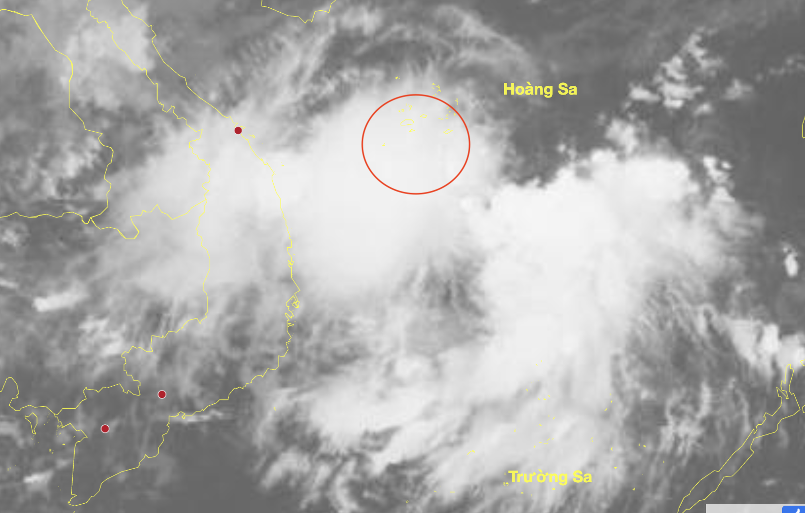
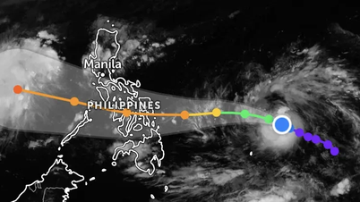
Low pressure area position at 1am November 1 - Photo: NCHMF
According to the National Center for Hydro-Meteorological Forecasting, there is currently a low pressure area in the East Sea (November 1).
Due to the influence of the tropical convergence zone with an axis at about 10-13 degrees North latitude connecting with the low pressure area in the Hoang Sa archipelago (at 1:00 a.m.), in the sea area from South Quang Tri to Quang Ngai , the Gulf of Thailand, the Central East Sea area has scattered showers and thunderstorms. In the Gulf of Tonkin, there are strong Northeast winds of level 5, sometimes level 6, gusting to level 7.
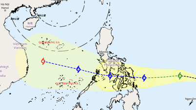
It is forecasted that today, in the northern East Sea (including Hoang Sa special zone), Bac Bo Gulf, and the sea area from southern Quang Tri to Quang Ngai, there will continue to be winds of level 5-6, gusting to level 7-8.
In addition, on the day and night of November 1, in the southern area of the Gulf of Tonkin, the sea area from Quang Tri to Ca Mau, from Ca Mau to An Giang , the Gulf of Thailand, the northern and central areas of the East Sea (including Hoang Sa special zone), and the surrounding area of the East Sea (including Truong Sa special zone) there will be scattered showers and thunderstorms.
During thunderstorms there is a possibility of tornadoes, strong gusts of wind level 6-7 and waves over 2m high.
During the day and night of November 2, the northern East Sea area (including Hoang Sa special zone) will have strong northeast winds of level 6, sometimes level 7 at night, gusting to level 8-9, rough seas, waves 2-4m high.
The Gulf of Tonkin and the sea area from Quang Tri to Quang Ngai has strong northeast winds of level 5, sometimes level 6, gusting to level 7-8, rough seas, waves 1.5-3m high.
All vessels operating in the above areas are at high risk of being affected by strong winds and large waves.
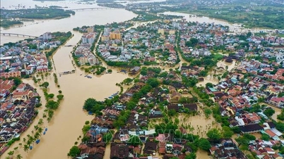
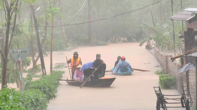
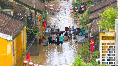
The meteorological agency also said that from last night to this morning, in the area from southern Nghe An to Da Nang and eastern Quang Ngai province, there was moderate rain, heavy rain , and locally very heavy rain and thunderstorms such as Ky Lac station (Ha Tinh) 221mm, Phong Nha station (Quang Tri) 232mm, Tra Kot station (Da Nang) 210mm, Nghia Trung station (Quang Ngai) 276mm,...
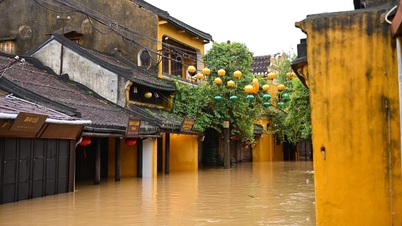
This morning, flood on Huong River (Hue city) is fluctuating above warning level 2.
Quang Tri rivers are fluctuating, other rivers from Hue city to Da Nang city are decreasing.
On Ngan Sau River, Ngan Pho River, La River (Ha Tinh) are rising.
It is forecasted that in the next 24 hours, flood on Huong River will continue to fluctuate above level 2.
It is forecasted that from this morning until early morning of November 3, the area from Ha Tinh to Da Nang and the east of Quang Ngai will have heavy to very heavy rain with common rainfall of 200-450mm, locally over 700mm.
Southern Nghe An and western Quang Ngai have heavy rain with common rainfall of 100-250mm, locally very heavy rain over 350mm.
In addition, during the day and night of November 1, in the area from Gia Lai to Lam Dong and the South, there will be scattered showers and thunderstorms with rainfall of 10-30mm, locally heavy rain over 70mm.
Thunderstorms may contain tornadoes, lightning, hail and strong winds.
During the day and night of November 3, the area from southern Nghe An to Quang Ngai will have heavy to very heavy rain with common rainfall of 100-200mm, locally over 350mm.
Heavy rain in the Central region is likely to last until around the night of November 4.
Warning: From today until November 5, there is a possibility of a flood on rivers from Nghe An to Ha Tinh.
Floods on rivers from Quang Tri to Quang Ngai are likely to rise again.
Flood peaks in the upper reaches of Ngan Sau and Ngan Pho rivers (Ha Tinh), Gianh rivers, Kien Giang rivers, Thach Han rivers (Quang Tri), and rivers from Hue city to Quang Ngai reached alert level 2-3, with some rivers above alert level 3.
Tuoitre.vn
Source: https://tuoitre.vn/xuat-hien-vung-ap-thap-o-bien-dong-mien-trung-tiep-tuc-mua-lon-20251101090803951.htm

![[Photo] Prime Minister Pham Minh Chinh chairs the second meeting of the Steering Committee on private economic development.](https://vphoto.vietnam.vn/thumb/1200x675/vietnam/resource/IMAGE/2025/11/01/1762006716873_dsc-9145-jpg.webp)


Comment (0)