
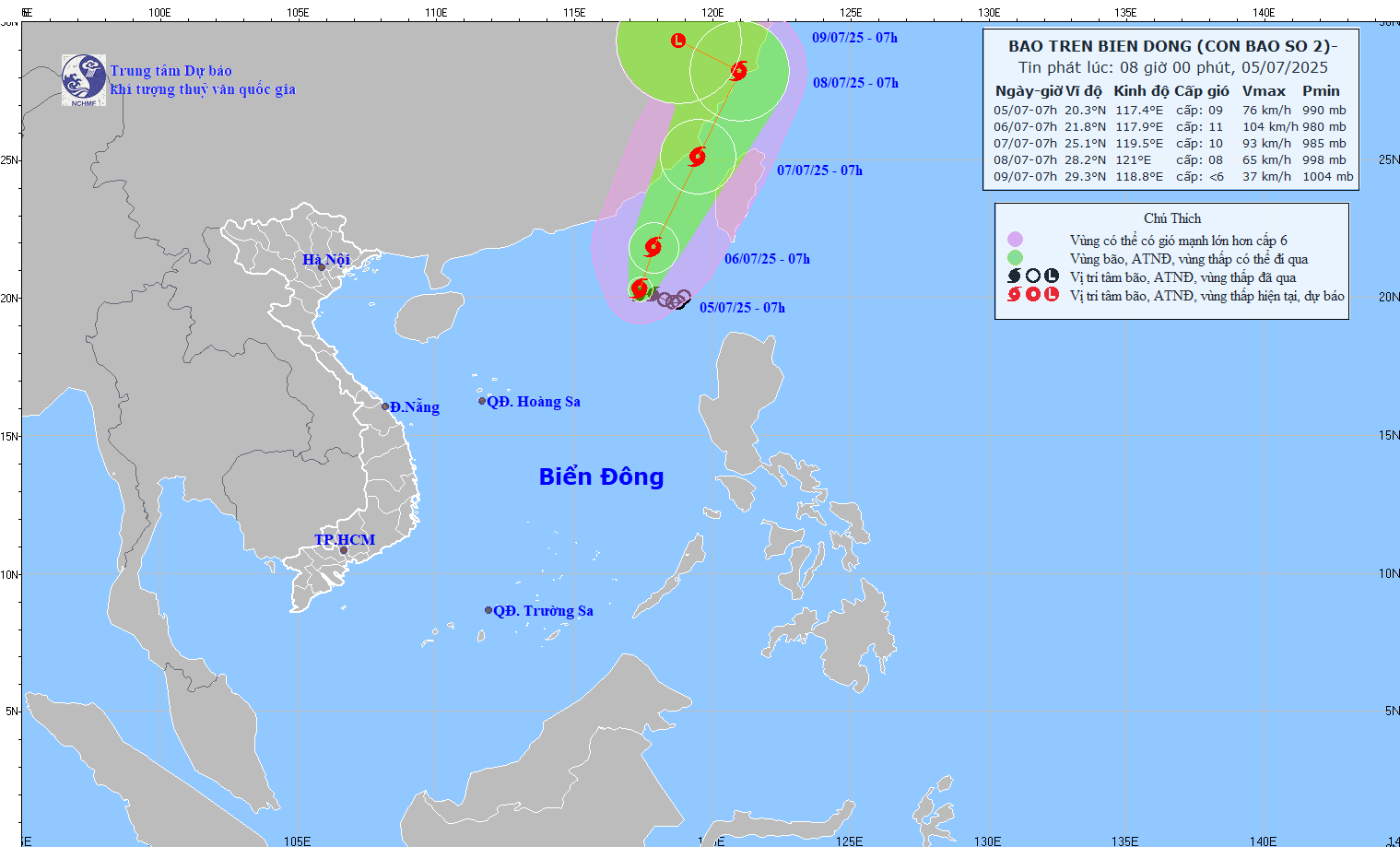
Forecast of the path of typhoon number 2 at 8:00 AM on July 5th.
At 7:00 AM on July 5th, the storm's center was located at approximately 20.3 degrees North latitude and 117.4 degrees East longitude, with a strength of level 8-9 (62-88 km/h) and gusts up to level 11. The storm was moving slowly in a west-northwest direction at a speed of about 5-10 km/h.
Forecasts indicate that at 7:00 AM on July 6th, Typhoon No. 2 will move northward at a speed of 5-10 km/h and is likely to intensify. The typhoon's center will be located at 21.8 degrees North latitude and 117.9 degrees East longitude, in the northeastern part of the South China Sea. Its intensity will be level 10-11, with gusts up to level 13.
Around the morning of July 7th, the storm was moving in a North-Northeast direction at a speed of about 15 km/h, with its center located over the sea off Fujian Province (China), and was forecast to continue moving inland into the country.
Forecast of storm developments over the next 24-72 hours.
Over the next 72 to 96 hours, Typhoon No. 2 will move in a west-northwest direction at a speed of approximately 10 km/h and gradually weaken into a low-pressure area.
Due to the impact of the storm, the northeastern part of the North East Sea is experiencing stormy weather, strong winds of force 7-8, reaching force 9-11 near the storm's center, with gusts up to force 13. The sea is extremely rough, with waves 4-6 meters high. Vessels operating in the dangerous zone are at high risk of being affected by thunderstorms, tornadoes, strong winds, and large waves.
NDS
Source: https://baothanhhoa.vn/ap-thap-nhiet-doi-da-manh-len-thanh-bao-so-2-254057.htm
![[Image] National Assembly discusses the implementation of the socio-economic development plan.](https://vphoto.vietnam.vn/thumb/1200x675/vietnam/resource/IMAGE/2026/04/20/1776696707422_ndo_br_img-20260420-185419-jpg.webp)

![[Photo] General Secretary and President To Lam meets with National Assembly delegates from ethnic minorities.](https://vphoto.vietnam.vn/thumb/1200x675/vietnam/resource/IMAGE/2026/04/20/1776696701056_a1-bnd-8331-3342-jpg.webp)


Comment (0)