
Map showing the predicted trajectory and intensity of Typhoon Fung-Wong at 2 PM on November 8th.
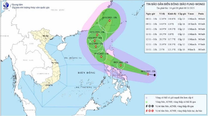
At 13:00 on November 8th, the typhoon's center was located at approximately 12.8 degrees North latitude and 130.6 degrees East longitude. The strongest winds near the center of the typhoon reached level 13 (134-149 km/h), with gusts up to level 16. It was moving in a west-northwest direction at a speed of about 30 km/h.
Forecasts indicate that around the morning of November 10th, Typhoon Fung-Wong is likely to move into the eastern part of the North East Sea.
Currently, Typhoon Fung-Wong is operating in a favorable environment with high sea surface temperatures (29-30 degrees Celsius) and low vertical wind shear, so its intensity will continue to increase and it has the potential to reach super typhoon status on November 9th. However, upon approaching the waters southeast of Luzone Island (Philippines), it will encounter unfavorable environmental conditions, causing it to likely weaken in intensity.
Around the morning of November 10th, Typhoon Fung-Wong is likely to move into the waters east of the North East Sea, becoming the 14th typhoon to operate in the South China Sea in 2025. At this time, the subtropical low-pressure branch to the north (the channel guiding the typhoon's movement) will weaken in intensity and expand further south. This will cause the typhoon to tend to move more northward. As it moves to higher latitudes, the typhoon will enter the channel of the upper-level westerly winds, so it is likely to change direction towards the northeast and move out of the South China Sea.
"Normally, at the end of the season, typhoons tend to move westward, or even west-southwestward, and make landfall in the southern central provinces. However, Typhoon Fung-Wong moved northward and out of the open. This is what's unusual about this typhoon," a meteorological expert commented.
Due to the combined influence of a strengthening cold front shifting eastward, strong northeasterly winds of force 6-7, gusting to force 8-9, have been observed in the eastern part of the North East Sea since the night of November 8th. From the night of November 9th, winds in this area will strengthen to force 8-9; near the storm's center, winds will reach force 10-12, gusting to force 14-15, with waves 3-5 meters high, later increasing to 6-8 meters. The sea will be extremely rough.
Around the morning of November 10th, Typhoon Fung-Wong is likely to move into the South China Sea with an intensity of level 13, gusting to level 16, and maintain its intensity as it moves northward. Therefore, from November 10th to 12th, the eastern part of the North South China Sea is likely to be affected by strong winds of level 11-13, gusting to level 16, with waves reaching 8.0-10.0 meters in height. The sea will be extremely rough.
All boats operating in the aforementioned hazardous areas are susceptible to the effects of thunderstorms, strong winds, and high waves.
Source: https://baotintuc.vn/xa-hoi/bien-dong-sap-don-con-bao-so-14-20251108150147774.htm

![[Photo] Conference announcing the Politburo's Decision on organizational and personnel matters](https://vphoto.vietnam.vn/thumb/1200x675/vietnam/resource/IMAGE/2026/04/01/1775017881825_bnd-2410-1472-jpg.webp)


Comment (0)