
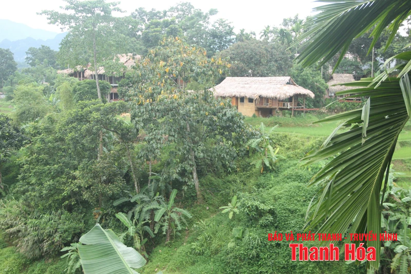
Many Thai ethnic minority households in Don village, Pu Luong commune, still live on the hillsides along the stream, facing a high risk of landslides during heavy rains and storms.
According to the Steering Committee for Disaster Prevention, Search and Rescue, and Civil Defense (PCTT, TKCN&PTDS) of Thanh Hoa province, there are currently 85 mountainous areas in the province with a high to very high risk of landslides. In fact, in recent years, especially after typhoons No. 3 and No. 4 in September 2024, many landslides have occurred in the mountainous areas, causing significant damage. From the 2024 rainy season to the present, many typical landslides have occurred, such as: Landslides in Kim Tan town and Thanh Yen and Thanh Truc communes, Thach Thanh district (formerly); landslide on Lung Dac hill in Khung village, Thiet Ke commune, Ba Thuoc district (formerly); landslides in the area of Nhu Xuan Secondary and High School (Thanh Quan commune, Nhu Xuan district, formerly); landslides in Cha Khot village (Na Meo commune, Quan Son district, formerly); Land subsidence and cracks in the residential area of Muong village (Trung Xuan commune, former Quan Son district); landslides on the embankment of the main Cua Dat canal section from K6+300 - K6+500 (Phung Giao commune, former Ngoc Lac district); landslides on the hillside near Lam Phu Secondary School (former Lang Chanh district)...
Following the completion of the merger of new communes, the Provincial Steering Committee for Disaster Prevention, Search and Rescue, and Civil Defense conducted a comprehensive survey and compiled data. Currently, throughout the province, there are 6,275 households/26,551 people in 82 communes and wards living in areas at risk of landslides. In the low mountainous areas, Xuan Du commune has 163 households with 753 people living in landslide-prone areas. Cam Thuy commune has 95 households/376 people living in high-risk landslide areas. In Thang Loc commune, parts of the former Xuan Loc and Xuan Thang communes currently have 203 households with nearly 800 people still living in areas at risk of landslides during heavy rain and storms. During the two recent storms, the commune developed plans and proactively relocated some households to sturdy structures such as cultural centers, schools, and solid houses in safe locations.
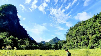
In the high mountainous region, the merged Pù Luông commune also has 136 households with 535 people living in areas at risk of landslides. The villages with the highest risk are Báng, Kho Mường, Niêm Thành, Eo Kén, Pà Ban, etc., each with dozens of families living on steep mountain slopes and along streams. Mr. Hà Văn Luyện, a resident of Bản Đôn village, Pù Luông commune, said: “When it rains heavily, water from the high mountain slopes flows down simultaneously, causing a very large flow in the area. Previously, many people were complacent, but now, thanks to awareness campaigns, many people are more proactive in preventing damage. My house is on a slope, bordered on two sides by earthen mountains. When there is information about an impending storm, I usually stock up on food supplies and, if required by the authorities, I will immediately relocate to ensure safety.”
In Muong Lat commune, nearly 500 people from 89 households live scattered across the mountain slopes, in areas at high risk of landslides. According to Lo Hoai Niem, Vice Chairman of the People's Committee of Muong Lat commune, during typhoon No. 3 at the end of July, the commune experienced prolonged heavy rain, forcing the evacuation of 5 households with 28 people from various villages to community centers and sturdy school buildings. After assessing the situation as safe, local forces helped the residents return to their stable lives.
Currently, there is no technology that can accurately predict landslides. Therefore, prevention remains the most effective solution. To ensure the safety of the people, during recent heavy rains and storms, the Provincial People's Committee and the Provincial Steering Committee for Disaster Prevention, Search and Rescue, and Civil Defense issued official dispatches and warnings about the risk of flash floods and landslides, requesting localities to urgently implement early response measures. During the 2025 rainy season, the Provincial Border Guard Command is also testing three unmanned UAVs to monitor landslide situations in complex mountainous terrain.
For areas at very high risk and locations where landslides and riverbank erosion have occurred, from September 2024 to the present, the Irrigation Sub-Department of the Department of Agriculture and Environment has advised the Chairman of the Provincial People's Committee to declare 13 emergency situations regarding landslides. The Department of Finance has allocated funds for localities to immediately address the consequences of natural disasters. The Irrigation Sub-Department of the Department of Agriculture and Environment has also advised the Provincial People's Committee to issue Plan No. 275/KH-UBND dated November 3, 2023, to implement the Project on preventing and combating riverbank and coastal erosion until 2030 in Thanh Hoa province.
According to information from the Standing Office of the Provincial Steering Committee for Disaster Prevention, Search and Rescue, and Civil Defense, the unit has issued a document requesting newly established communes to focus on reviewing all high-risk areas for landslides and flooding along rivers and streams to adjust and update response plans, especially evacuation and relocation plans, to ensure the safety of people's lives. At the same time, the communes are required to strictly manage the situation to prevent people from illegally constructing houses in high-risk landslide areas, prohibit leveling mountains and slopes for construction, and stop illegal exploitation of resources and minerals that increase the risk of landslides.
Regarding evacuation plans, by August 2025, localities in mountainous areas had reported the completion of evacuation plans in the event of natural disasters, including plans to evacuate 6,275 households with 26,551 people living in areas at risk of landslides.
Text and photos: Linh Truong
Source: https://baothanhhoa.vn/phong-tranh-nguy-co-sat-lo-259330.htm
![[Photo] The General Secretary, President and his wife begin their state visit to the Philippines.](https://vphoto.vietnam.vn/thumb/1200x675/vietnam/resource/IMAGE/2026/05/31/1780230559452_anh-man-hinh-2026-05-31-luc-19-28-11.png)

![[Photo] Solemn bathing ceremony and Buddha procession in Hue](https://vphoto.vietnam.vn/thumb/1200x675/vietnam/resource/IMAGE/2026/05/31/1780228263543_1-jpg.webp)

![[Photo] Admire the coral "masterpiece" amidst the million-year-old heritage of Dak Lak province.](https://vphoto.vietnam.vn/thumb/1200x675/vietnam/resource/IMAGE/2026/05/31/1780221235105_anh-man-hinh-2026-05-31-luc-16-53-27.png)


![[Video] Sunset at Lap An Lagoon – Where the sun sets over the fishing nets](https://vphoto.vietnam.vn/thumb/340x192/vietnam/resource/IMAGE/2026/05/31/1780192137701_beach-landscape-sea-water-nature-grass-745871-pxhere-com.jpeg)


![[Photo] Admire the coral "masterpiece" amidst the million-year-old heritage of Dak Lak province.](https://vphoto.vietnam.vn/thumb/402x226/vietnam/resource/IMAGE/2026/05/31/1780221235105_anh-man-hinh-2026-05-31-luc-16-53-27.png)


Comment (0)