
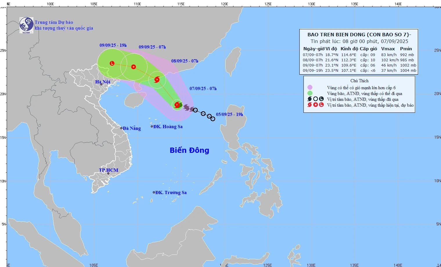
Map showing the predicted path and intensity of Typhoon No. 7 at 8:00 AM on September 7, 2025.
At 7:00 AM on September 7th, the storm's center was located at approximately 18.7 degrees North latitude and 114.6 degrees East longitude, in the northern part of the South China Sea. The strongest winds near the storm's center were at level 9 (75-88 km/h), with gusts up to level 11.
Forecasts indicate that by 7:00 AM tomorrow, September 8th, the storm's center will be located at approximately 21.6 degrees North latitude and 112.3 degrees East longitude, in the sea south of Guangdong province (China). Its intensity will be level 10, with gusts up to level 13. A level 3 risk warning is in effect for the northern part of the South China Sea.
As of 7:00 AM on September 9th, the storm's center was located at approximately 23.1 degrees North latitude and 109.6 degrees East longitude, over land in Guangdong province (China). Its intensity was level 6, with gusts up to level 8. A level 3 risk warning was issued for the northwestern part of the South China Sea.
At 7 PM on September 9th, the storm's center was located at 23.5 degrees North latitude and 107.1 degrees East longitude, over land in Guangxi province (China). Its intensity had decreased to below level 6, weakening into a low-pressure area.
NM
Source: https://baothanhhoa.vn/trong-3-gio-qua-bao-so-7-it-dich-chuyen-260784.htm


![[Image] National Assembly discusses the implementation of the socio-economic development plan.](https://vphoto.vietnam.vn/thumb/1200x675/vietnam/resource/IMAGE/2026/04/20/1776696707422_ndo_br_img-20260420-185419-jpg.webp)


![[Photo] General Secretary and President To Lam meets with National Assembly delegates from ethnic minorities.](https://vphoto.vietnam.vn/thumb/1200x675/vietnam/resource/IMAGE/2026/04/20/1776696701056_a1-bnd-8331-3342-jpg.webp)


Comment (0)