
The flood of over 30 years.
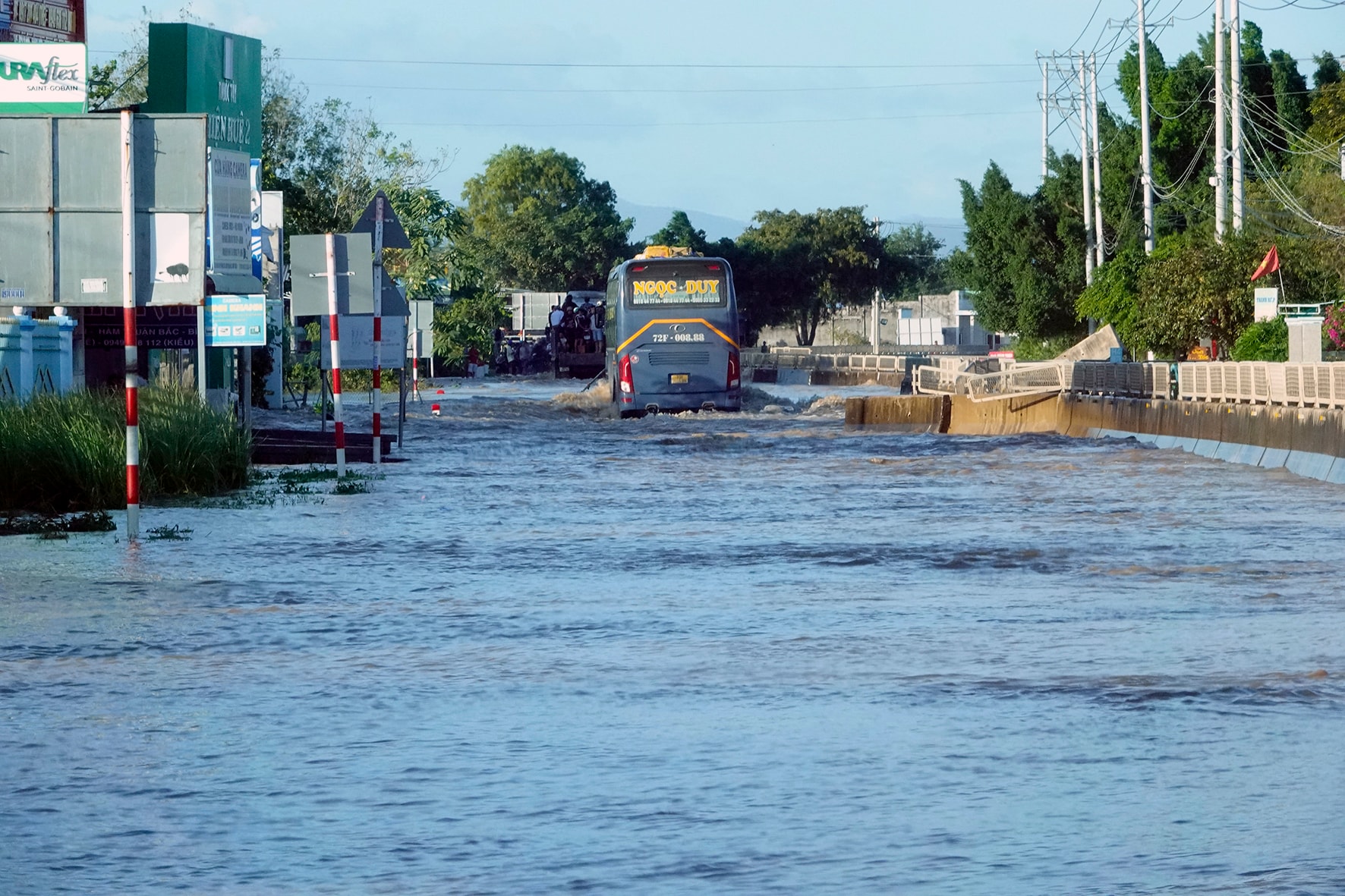
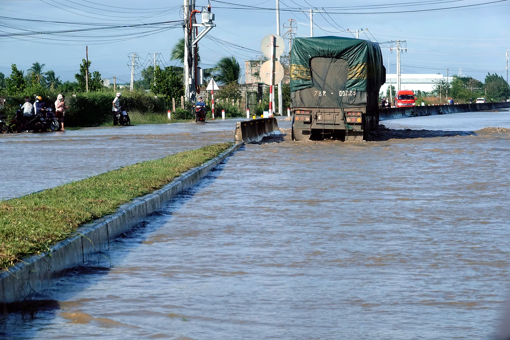
At 4 PM on December 4th, near Ong Tam Bridge on National Highway 1A, in Hamlet 1, Hong Son Commune, Lam Dong Province, traffic, mostly cars and motorbikes, was forced to travel against the flow of traffic. This was despite police warnings at the Ta Zon intersection checkpoint: "Floodwaters are rising at the Gop intersection; please take Provincial Road 715 to rejoin National Highway 1A at the Luong Son intersection." Those needing to travel to Hong Son Commune had no choice but to proceed. Upon arrival, they found the water flowing rapidly and there were no safe turns, forcing them to go against the flow. We initially intended to do the same, but because we wanted to enter the flooded area to assess the situation and film, the Hong Son Commune leadership dispatched a 4x4 vehicle. It was certainly able to navigate the strong current, even though the concrete median barrier had been torn apart by the floodwaters during the night of December 3rd and the morning of December 4th.
At 10:30 PM on December 3rd, in area 1, Liem Binh village, the first area to receive water from the branch canal of Canal 812 - Chau Ta, the project transferring water from Song Luy Lake (formerly Bac Binh district) to Song Quao Lake (formerly Ham Thuan Bac district), was flooded. Fortunately, the residents had evacuated earlier that afternoon, having learned from the floods on October 28th and November 2nd. Subsequently, torrential rain continued throughout the night, causing the water level to rise rapidly and flood 10 villages. This was also the time when the commune evacuated residents from the flooded areas to safety. At 4:00 AM, with the additional assistance of the military , the provincial police, and canoes and jet skis from organizations in Phan Thiet, Hong Son commune successfully evacuated over 600 households. There were no casualties.
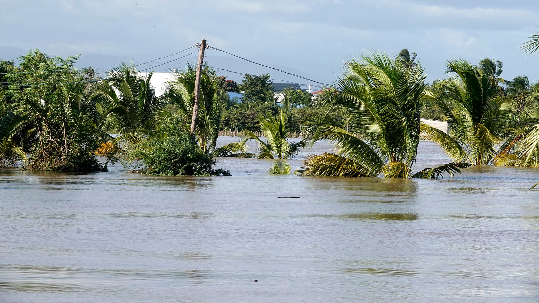
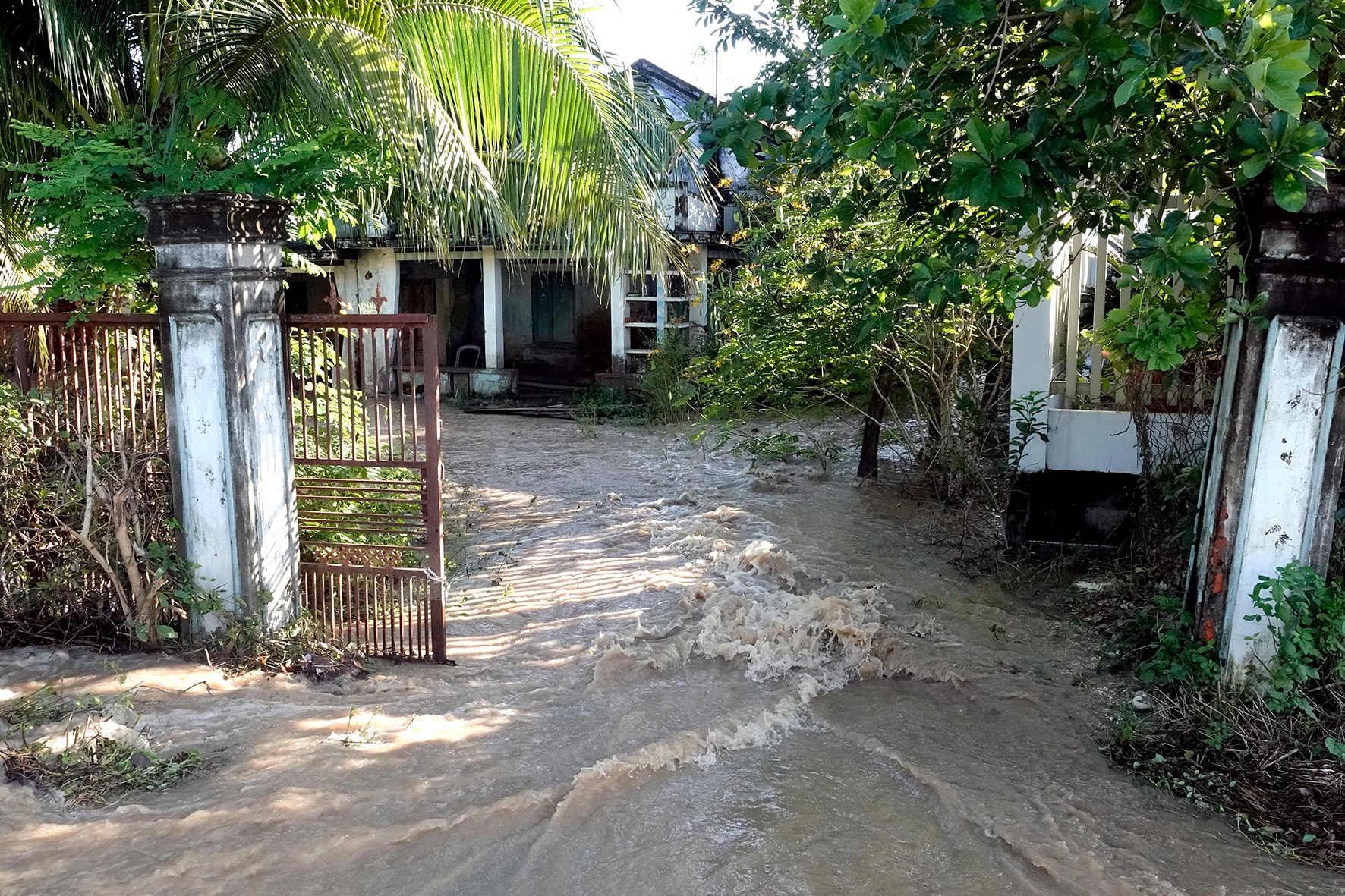
At 5 PM on December 4th, at the commune headquarters, along the way, we saw numerous points distributing free meals and water. Our vehicle was preparing to enter the flooded area in hamlets 1, 2, and 3. Seeing this, a charity group from Phan Thiet approached us, asking us to deliver food and water to the residents there, as they were worried their vehicle wouldn't be able to get through. We hoped our high-clearance vehicle could navigate the raging floodwaters. Indeed, the deeper we went, the more the area was covered in white water, the only sounds being the force of the flood, even though the sun was shining. The scene showed water knocking down gates, tearing down doors, and climbing coconut trees... Houses on higher ground in hamlet 2 were not evacuated. People were gathered, watching the water as if it were a festival. Everyone seemed calm, showing no signs of worry or fear, unlike what is often seen in flooded areas.
“Grandma, is your house flooded?” I asked the oldest woman in the village, Tran Thi Sang, in Hamlet 2. “No, child, why would there be flooding here? I’m 80 years old and I’ve never seen a flood like this before. Well, there have been some, but not as many, before the government built this road. It’s been over 30 years since we’ve had such a big flood here,” she said in one breath, as if the flooding on the evening of December 3rd had caused her much thought, and now someone was asking about it. That’s also why she was now going to see the flood with everyone. As for us, we couldn’t get to Hamlet 3, which was isolated by floodwaters, because the road was blocked by landslides…
An unexpected answer
It wasn't just Mr. Sang who wondered; anyone familiar with the Hong Son and Hong Liem areas (now merged into Hong Son commune), considered a buffer zone of the Le area, knew it was a drought-stricken region. Yet now there was flooding, a historically significant flood, when it was vaguely apparent that there had never been a memorable flood there before. In reality, there were no rivers or streams in the commune. "The commune has compiled a preliminary map analyzing the floodwaters' path, showing that during heavy rains, streams and rivers outside the commune's territory overflowed into Canal 812 - Chau Ta, then flooded the commune, causing unexpected flooding," said Mr. Nguyen Linh Chon, Secretary of the Hong Son Commune Party Committee, still exhausted after a night spent with officials helping residents avoid the flood. In the mind of this commune leader, the story of the unexpected floods, a drought-stricken area yet experiencing severe flooding, is understandable. The commune was always prepared with the "four on-the-spot" flood monitoring system, never neglecting its duties whenever it rained, but the surprise this time was the sudden and rapid rise of the floodwaters, as if a large river flowed through the area, coupled with the release of water from upstream irrigation reservoirs and the rising tide from the sea.
But in reality, that's not the case. In Hong Son commune, there's only the Suoi Da reservoir with a capacity of 9 million m³ ; this time, it also released 15 m³ /s of water, but it wasn't the main cause. The Can River originates elsewhere, enters the commune via the Bang Lang bridge, then merges with streams flowing from the sand dunes, passes through the old Ham Duc area, and joins two other small rivers and streams before flowing into the Cai River - Phu Long (Ham Thang ward) and then into the sea. The name of the river itself suggests the water situation during the dry season. But during the rainy season, with such a connected flow, and especially during heavy rains like the night of December 3rd, the Can River naturally flows towards the Cai River downstream. However, at this time, the Cai River was already full, as the Song Quao reservoir continuously released water from the night of December 3rd to December 4th, with a discharge rate of 300-600 m³ /s. From here, the water of the Can River, having no outlet, rose on its own, severely flooding both banks. This was likened to a second pincer movement, alongside the first, which was the water from rivers and streams overflowing the 812 - Chau Ta canal, causing severe flooding in Hong Son commune and water overflowing onto National Highway 1A. The estimated damage to roads, crops, and livestock as of 9:00 AM on December 5th was 9 billion VND.
Therefore, no one was surprised by the situation that the flood created in Hong Son, a region that has long suffered from drought. It's worth remembering that when the 812-Chau Ta inter-district water transfer canal was completed in 2010, the commune had a branch canal to bring water to the lowland areas. Thanks to this, the entire commune cultivated 1,330 hectares of rice/3 crops and 771 hectares of dragon fruit, mainly on the other side of National Highway 1A. On this side of National Highway 1A, Hong Son commune estimates about 2,000 hectares, some of which produce only one crop, thanks to water from sand dunes and rainwater. The commune is proposing the construction of an irrigation project to transfer water to this area to open up opportunities for diversified economic development, especially tourism services, given its proximity to a famous national tourist area.
Source: https://baolamdong.vn/vung-khat-ngap-lut-408471.html


![[Photo] General Secretary and President To Lam presides over a meeting on assessing national development resources.](https://vphoto.vietnam.vn/thumb/1200x675/vietnam/resource/IMAGE/2026/05/20/1779253785852_a1-bnd-2943-8519-jpg.webp)

![[Photo] National Assembly Chairman Tran Thanh Man working with the Standing Committee of the Economic and Financial Committee](https://vphoto.vietnam.vn/thumb/1200x675/vietnam/resource/IMAGE/2026/05/20/1779249584387_ndo_br_1-jpg.webp)


Comment (0)