
Within a few hours on the morning of September 22nd, seven earthquakes occurred in Kon Plông district, causing aftershocks ranging from 2.7 to 4.4 magnitude, but without causing any damage, according to the Institute of Geophysics.
An earthquake with a magnitude of 4.4 occurred in Kon Plông district, Kon Tum province at 7:45 AM, at a depth of approximately 8 km. Residents in neighboring areas such as Kon Rẫy district and Kon Tum city (Kon Tum province) also felt the tremors. Around 8:00-8:30 AM, two more earthquakes occurred at a depth of 10 km, with aftershocks ranging from 2.7 to 2.8 magnitude. Most recently, at 10:25 AM, an earthquake with a magnitude of 3.6 occurred. The magnitude of these earthquakes does not pose a significant natural disaster risk. The Earthquake Information and Tsunami Warning Center of the Institute of Geophysics continues to monitor these earthquakes.
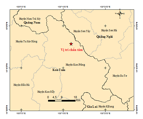
The epicenter of the 3.6 magnitude earthquake on the morning of September 22nd. Source: Earthquake Information and Tsunami Warning Center.
Dr. Nguyen Xuan Anh, Director of the Institute of Geophysics, stated that Kon Tum is located within a series of triggered earthquakes and a weak earthquake zone. Therefore, the maximum earthquake magnitude in the area does not exceed 5.5. Observations suggest that the cause of this phenomenon is related to triggered earthquakes caused by the reservoir.
In July of this year, within less than ten hours on July 7th, 12 earthquakes occurred in Kon Plông district, causing aftershocks ranging from 2.5 to 4.2 magnitude. According to Dr. Xuân Anh, this recurring phenomenon shows that "triggered earthquakes also occur in cycles. There are times when earthquakes occur in a series, and other times when there are only a few occasional ones, closely related to the water storage operation of hydroelectric reservoirs," he said.
Previously, Associate Professor Dr. Nguyen Hong Phuong, a seismologist at the Institute of Geophysics, shared with VnExpress that the cause of induced earthquakes is understood to be due to human impact on nature, rather than natural earthquakes like those in northern regions, caused by natural fault zones.
According to Associate Professor Phuong, induced earthquakes follow an easily understandable pattern, mostly occurring in areas with active reservoirs, especially hydroelectric reservoirs or large water storage reservoirs. When a reservoir is filled with water, the large volume of water exerts significant pressure on the reservoir bottom. Combined with local faults (even small ones), this increased stress on the large water column causes induced earthquakes.
The triggered earthquakes typically follow a cycle, occurring after periods of water accumulation and the rainy season. Once they reach a peak, they begin to diminish, forming a series of medium- and moderate earthquakes, before eventually dying off. "The duration of this dying-off will need to be studied, depending on local monitoring stations, as the cycle will vary in different regions," he said.
Mr. Xuan Anh stated that continued monitoring of seismic activity is still necessary to detect any abnormalities and notify the public to reassure them. He also noted that earthquake hazard assessments are essential and need to be updated annually to support socio -economic development planning and earthquake-resistant design for various types of structures, from key projects to residential areas.
Statistics show that over the 117 years from 1903 to 2020, the Kon Plông area recorded only about 33 earthquakes of magnitude 2.5 or higher. However, since 2021, over 200 new earthquakes have occurred there. Experts agree that it is very difficult to accurately predict the timing of earthquakes.
Nhu Quynh
Source link


![[INFOGRAPHIC] Ugreen FineTrack 2 Soccer Design](https://vphoto.vietnam.vn/thumb/402x226/vietnam/resource/IMAGE/2026/05/25/1779680273219_info-bongdinhvi-a-thumb-jpg.webp)


Comment (0)