
US: Satellite images reveal the catastrophic scale of a massive wildfire that ravaged the town of Lahaina on the Hawaiian island of Maui, killing dozens of people.
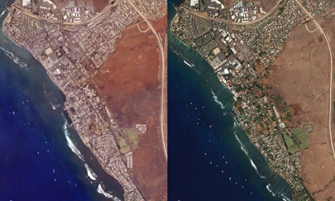
The town of Lahainna before the devastating bushfires. Photo: Maxar Technologies
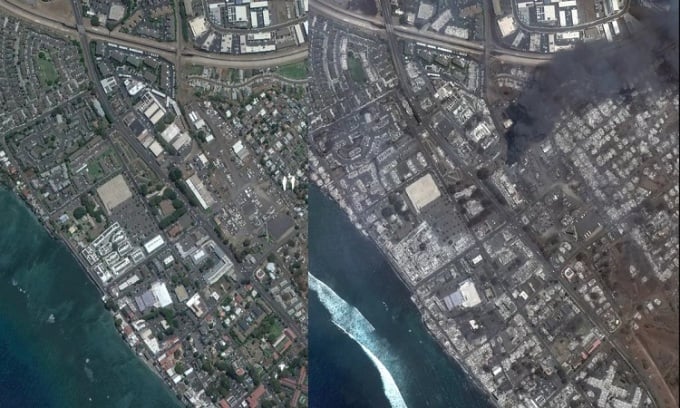
Out-of-control wildfires erupted on drought-stricken Maui earlier this week, threatening the Hawaiian town of Lahaina. Satellite images provided an aerial view of the disaster. The firestorm, which engulfed the historic town on Hawaii's second-largest island, started on August 8th for unknown reasons, according to Space . The blaze quickly escalated to enormous scale shortly afterward, partly fueled by strong winds from Hurricane Dora. At least 68 people have died and thousands have been left homeless.
Meteorologists explain that although Hurricane Dora passed more than 1,200 km south of the Hawaiian Islands, its interaction with a high-pressure area in the northern Pacific Ocean created strong winds, causing the fire to spread rapidly across the arid surface of Maui.
The town of Lahaina was devastated by fire. Photo: Planet
Images provided by two American Earth observation companies, Maxar Technologies and Planet, compare the town of Lahaina and its surroundings before and after the fire. While Maxar's June photo showed the neighborhood with plenty of lush greenery, the September 9 image reveals a landscape covered in brown and gray ash with thick columns of dark smoke rising into the air. Planet's photo taken the following day also captured a similar scene after the smoke cleared.
NASA's Landsat 8 satellite also captured images of the burning town on August 8th, shortly after the first reports of the fires. In that image, almost the entire town, with a population of approximately 12,000 people before the disaster, was ablaze in orange. Europe's Sentinel-2 Earth observation spacecraft also captured the area engulfed in flames when it flew over it on August 8th. The firestorm in Hawaii was so intense that it was clearly visible in images taken by a geostationary weather satellite 36,000 km from Earth.
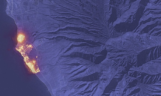
Wildfires in Lahaina as seen from the Sentinel-2 satellite. Photo: NASA
The wildfire continued to rage on Maui Island on August 11th. Hawaii Governor Josh Green stated that the fire was "the largest natural disaster in the history of the state of Hawaii" and that 80% of the town of Lahaina had been destroyed. According to the US National Weather Service, the winds fanning the blaze were weakening and would remain moderate over the weekend and into next week.
According to CBS News, National Guard helicopters involved in firefighting had to land due to winds exceeding 97 km/h blowing across the island. In fact, strong winds alone were enough to devastate the area, knocking down power lines and destroying homes. Relief and humanitarian aid efforts were further complicated by Maui's remote location and limited resources for addressing a disaster of this scale.
An Khang (According to Space )
Source link


Comment (0)