
 |
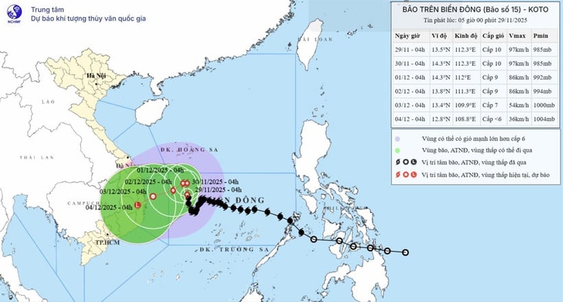
| This map shows the predicted trajectory and intensity of Typhoon No. 15, released at 5:00 AM on November 29th. |
The strongest winds near the center of the storm are at force 9-10 (75-102 km/h), with gusts up to force 13, moving in a north-northwest direction at a speed of 5-10 km/h.
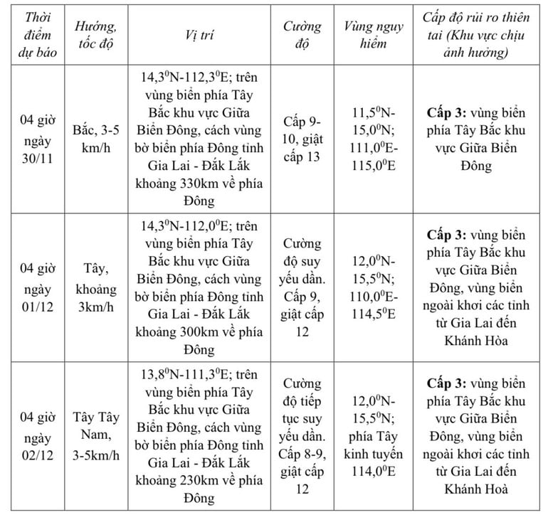
Forecast of storm developments (over the next 24 to 72 hours):
 |
Over the next 72 to 120 hours, the storm will move slowly west-southwest at a speed of 3-5 km/hour and its intensity will continue to weaken further.
Strong winds, big waves
In the northwestern part of the central South China Sea, winds are strong, reaching force 7-8; near the center of the storm, winds are strong, reaching force 9-10, with gusts up to force 12-13; sea waves are 3-5m high, and 6-8m near the center of the storm; the sea is very rough.
Offshore areas from Gia Lai to Khanh Hoa will experience strong winds of force 6-7, later increasing to force 8, gusting to force 9-10, with waves 4-6 meters high and rough seas. Vessels operating in these dangerous areas are at risk of being affected by thunderstorms, tornadoes, strong winds, and high waves.
Nhan Dan Newspaper
Source: https://baodongnai.com.vn/kinh-te/moi-truong/202511/bao-so-15-giat-cap-13-di-chuyen-cham-cf00190/
![[Photo] Da Nang: A sea of people respectfully paying homage to the Bodhisattva Avalokiteshvara.](https://vphoto.vietnam.vn/thumb/1200x675/vietnam/resource/IMAGE/2026/04/06/1775454198203_ndo_br_lh24-jpg.webp)


![[Photo] National Assembly Chairman Tran Thanh Man takes the oath of office](https://vphoto.vietnam.vn/thumb/1200x675/vietnam/resource/IMAGE/2026/04/06/1775453300886_ndo_br_1-2229-jpg.webp)


![[Infographic] Key indicators for the period 2026-2030 to achieve "double-digit" growth targets](https://vphoto.vietnam.vn/thumb/402x226/vietnam/resource/IMAGE/2026/04/06/1775450004801_fb4e219c8aa77c339a75ff13c44b2e595f8db215db15da7b4648b200deade68240d89ec5e4bd2e86c42f5ed9eeb-_ndo_br_chi-tieu-2-con-so-thumb-1.jpeg)


![[Photo] Sidewalks in Vung Tau ward are now more spacious.](https://vphoto.vietnam.vn/thumb/1200x675/vietnam/resource/IMAGE/2026/04/06/1775455388046_5-6796-jpg.webp)


Comment (0)