
Standing before the cascading Ban Gioc waterfall, I realized that the border is not just a line on a map. It is clearly present in the sound of the waterfall, in the red flag with a yellow star flying in the border sky, and in the Quây Sơn river silently winding around – where the Tay ethnic people have lived for generations, preserving this borderland.
A unique experience
To reach Trung Khanh – a remote border region of Cao Bang province – it took me a whole day of travel: I took the earliest flight to Hanoi , then boarded a car, traversing numerous mountain passes. In response to my question about when we would arrive at Ban Gioc, the driver said we should count seven passes to reach our destination: Giang Pass, Gio Pass, Ma Phuc Pass… I leisurely admired the forests and the continuous mountain ranges. At each interesting location, he would stop the car so we could rest, take pictures, and share some stories: stories about the hero Nung Tri Cao, stories about the unique plants of each place. Cao Bang thus appeared very close and vivid through the stories of a genuine, kind local, familiar with every winding road.
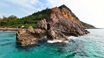
The early morning sun awakened Chongqing; my phone showed the temperature was only about 13 degrees Celsius. Ban Gioc Waterfall, shrouded in swirling mist, appeared ethereal and otherworldly, like a fairyland on earth. Before me was a vast landscape: on one side were rice paddies after the harvest, on the other, water cascading down from above over layers of limestone, creating white sprays like mist, shimmering and magical in the sunlight.
Not only famous for its natural beauty, Ban Gioc Waterfall is also located in a very special geographical location: on the border between Vietnam and China. It is the largest natural waterfall in Southeast Asia, over 60 meters high, with the longest slope measuring approximately 30 meters, divided into many consecutive limestone layers and spanning hundreds of meters. Next to Ban Gioc Waterfall is Milestone 836, a landmark of sacred historical significance.
The Vietnam-China land border is 1,449.566 km long, starting from Dien Bien and ending in Quang Ninh. Among the seven northern border provinces that this border passes through, Cao Bang has the most border markers: 634 markers (469 main markers, 165 auxiliary markers). Marker 836 is the last marker erected along the border between the two countries.

This is a double marker with the same number: on the Vietnamese side it is 836(2), on the Chinese side it is 836(1). Because it is a pair of markers with the same number, both sides of marker 836(2) are engraved with the word "Vietnam". The number 2001 on the marker is not the year marker 836 was placed but records the event in 2001, when Vietnam and China completed the demarcation and placement of markers along the entire land border. In fact, marker 836 was placed on January 14, 2009.
The Bản Giốc waterfall serves as a natural boundary, with the midpoint of the waterfall marking the border between Vietnam and China. According to the Agreement on Cooperation in Protecting and Exploiting the Tourism Resources of Bản Giốc Waterfall, citizens of both countries are permitted to travel and visit the waterfall but are not allowed to go ashore. Therefore, a trip to Bản Giốc, cruising on boats to admire the borderland, offers visitors a very special and sacred experience.

To the source of the Quay Son River
Gazing at the cascading white foam of Ban Gioc waterfall, I wondered what source created such a magnificent spectacle. Driven by curiosity, I spent a day wandering upstream on the Quay Son River – where the tranquil, poetic waters meander through limestone hills, terraced rice fields, and the villages of the Tay and Nung people in Ngoc Con and Phong Nam.
During the recent harvest season, the vast fields were left with only stubble. The driver said that if we had arrived a few weeks earlier, we could have witnessed firsthand the golden landscape of Cao Bang's harvest season stretching across the valleys on both banks of the Quay Son River.
The Quây Sơn River originates in Guangxi (China) and flows into Vietnam near the Pò Peo border gate. Its emerald green waters reflect peaceful villages, lush bamboo groves, herds of buffalo and horses grazing peacefully, and swaying white reeds. Looking at the gentle flow of the river upstream, it's hard to imagine that at some points, it encounters massive limestone formations before cascading down to create the majestic Bản Giốc waterfall amidst the mountains of Northeast Vietnam. From Bản Giốc waterfall, the Quây Sơn River continues along the Vietnam-China border, then flows back into China at the Lý Vạn border gate, concluding a complete and enchanting journey through Vietnam.
Along the Quây Sơn River, the Tay and Dao ethnic groups have built many waterwheels to carry water to irrigate their terraced rice fields. Thanks to these waterwheels, rice, corn, and other crops in the fields along both banks of the river have sufficient water year-round, resulting in bountiful harvests every season. During the rice harvest season, in sections with small waterfalls along the banks, people build water-powered rice mills. After a night, the rice in the mill is milled into pure white rice – a simple yet ingenious labor method of the mountain dwellers.
On the Quây Sơn River, flocks of ducks swimming playfully reminded me of a famous dish from the border region: Trùng Khánh roast duck. Free-range ducks are marinated, stuffed with mac mật leaves, and then roasted over charcoal until the skin is golden, crispy, and fragrant. The Tay and Nung people have a saying: "Bươn chiêng kin nựa cáy, bươn chất kin nựa pết," meaning: In the first lunar month, eat chicken; in the seventh lunar month, eat duck. These dishes are not only culinary delights but also cultural aspects deeply connected to the lives of the people in the border region.
Leaving the Quây Sơn River, we visited Khuổi Ky stone village – a small village nestled at the foot of limestone mountains, where time seems to slow down. The road leading into the village is paved with stone; the steps, fences, and even the house walls are built from mountain stone. Amidst the green of the mountains and forests, the stilt houses with yin-yang tiled roofs appear ancient and rustic, as if they stepped out of a bygone story.
Villagers say these stone stilt houses have existed for hundreds of years, since around the end of the 16th century, when the Mac dynasty came to Cao Bang to build fortifications. To this day, only 14 stone stilt houses remain in the village, still retaining almost their original appearance.
Today, Khuoi Ky Stone Village not only welcomes domestic visitors but also attracts many international tourists. In the ancient stone houses, guests and hosts gather around a cup of hot tea, enjoying freshly baked donuts, chatting in broken English interspersed with friendly smiles. Some even try on the traditional indigo clothing of the Tay people to take記念 photos amidst the ancient stone village. I suddenly realized that these solemn stone houses are not only a cultural heritage of the Tay people, but also a testament to a community that has clung to this land and village in the border region for centuries.

The long business trip finally came to an end, and it was time to say goodbye to Bản Giốc, to the Quây Sơn River – where I touched the border marker and understood that the beginning of a nation can sometimes be so clear and vivid: a river, a waterfall, a village, and the people quietly clinging to the land on the nation's frontier.
And perhaps, the homeland is not just something to see, to name, but also something to touch—with all that closeness, sacredness, and very ordinary feeling.
Source: https://baolaocai.vn/cham-vao-to-quoc-post897200.html


Comment (0)