
For centuries, Quang Yen town has continuously been the largest and most important political , military, economic, and cultural center of the entire northeastern coastal and island region. However, throughout its history, Quang Yen has experienced many ups and downs, serving as a town, a provincial capital, a district, and then a bustling city.
Archaeological findings in the Bach Dang River area have proven that in ancient Quang Yen, there was a thriving trade and the emergence of a merchant and urban class. Ancient tombs from the Eastern Han dynasty discovered in Tien An, Hoang Tan, and Song Khoai communes show that their owners were not Han Chinese but Vietnamese merchants. According to Dr. Nguyen Viet, Director of the Southeast Asian Prehistory Center, the Bach Dang area during the Au Lac period was densely populated. This formed the foundation for a prosperous trading period in Giao Chi.
When Giao Chau became a major hub on the maritime Silk Road around the Common Era, the Bach Dang estuary and the waterways and land routes extending into Giao Chi must have been the main trade routes for the entire region. This port area served as the vital gateway to the country, not only for defending against invasion but also for facilitating trade. The Bach Dang estuary played a crucial role as a regional trade center from 4,000 years ago, flourishing during the Au Lac, Nam Viet, and Giao Chau periods, from the 3rd century BC to the 3rd century AD.
Mr. Le Dong Son, former Head of the Culture and Sports Department of Quang Yen Town, believes that: On the vast tidal flats along Duong Hac, Hoang Tan commune, there are still many fragments of glazed ceramics from the Ly, Tran, and Le dynasties lying under mangrove trees. Perhaps Ben Giang and Duong Hac, belonging to Hoang Tan commune, were once trading ports within the Van Don trading port system; otherwise, it was a transit point for goods transported by waterway to Van Don trading port.
According to the book "History of the Party Committee of Quang Yen Town" published by the Political Theory Publishing House in 2020, starting in 1802, simultaneously with the establishment of the Nguyen Dynasty, King Gia Long established the Yen Quang district, encompassing the entire Northeast region, with the area of present-day Quang Yen town as the district capital. He appointed Nguyen Huu Dao as the district governor, Nguyen Viet Co as the deputy governor, and Nguyen Van Kim as the deputy deputy governor. In the fourth year of Gia Long's reign, 1805, the king ordered the construction of the Quang Yen Confucian Temple as a place for teaching.
In 1822, the king renamed Yen Quang town to Quang Yen town. From 1802 to 1825, the Yen Quang town center was not fortified and relied on the terrain of Tien Son mountain. In 1826, King Minh Menh ordered the construction of an earthen rampart, surrounded by the streets of Yen Hung, Khe Chanh, and Tien Mon.
In 1832, King Minh Mệnh carried out administrative reforms to establish Quảng Yên province, and the Quảng Yên district capital was renamed Quảng Yên provincial capital. Throughout the Nguyễn dynasty, the Quảng Yên provincial capital area remained the provincial administrative center and the leading urban center in the entire Northeast region. It wasn't until 1886 that King Tự Đức ordered the construction of the Quảng Yên citadel using bricks, leaving behind the remains that can still be seen today.
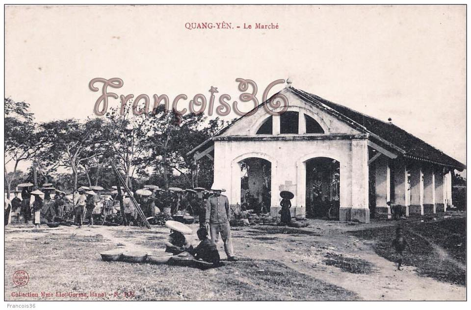
When the French occupied Quang Yen, starting in 1883 they built houses for the French commissioners, secret police, customs offices, treasury, Rung Market, etc. The French also expanded some old streets, specifically Yen Hung Street, Tran Hung Dao Street, Nguyen Du Street, and what are now Hoang Hoa Tham Street. Tien Mon Street was renamed Gia Long Street and Pham Ngu Lao Street. Later, Gia Long Street was renamed Doan Ket Street, and then Ngo Quyen Street.
Khe Chanh Street was renamed Truong Quoc Dung Street, then later Tran Khanh Du Street. During the French colonial period, Quang Yen became the provincial capital of Quang Yen province. It was a resort town and the center of the French colonial administration's control over the Northeast region.
On July 20, 1945, the revolutionary army liberated Quang Yen town, the first provincial capital in the country to seize power during the August Revolution. The revolutionary government was established, retaining Quang Yen as its provincial capital. On February 28, 1947, the French returned to occupy Quang Yen town until May 25, 1955.
From the early 1950s, Quang Yen continued to serve as the central town of Quang Yen province in the Hong Quang region, within the provincial-level local administrative system of the Democratic Republic of Vietnam. On July 2, 1964, after the establishment of Quang Ninh province, with Hon Gai town as the provincial capital, the Government issued a decision to change Quang Yen town to Quang Yen township and designate it as the district capital of Yen Hung district.
The current name of Quang Yen refers to a town in Quang Ninh province. Quang Yen currently comprises two parts: Ha Nam and Ha Bac. Due to the rapid pace of urbanization, some village names in the old Quang Yen have been changed to commune or ward names, such as Phong Coc and Cam La. Some village names have become hamlet or neighborhood names, such as Hung Hoc, Vi Duong, Yen Dong, Trung Ban, Khe Chanh, Khoai Lac, Yen Lap, Dong Linh, and La Khe.
Thus, Quang Yen town currently has 19 commune-level administrative units, including 11 wards with more than 100 neighborhoods. In the new context, Quang Yen is striving to reaffirm its original position, becoming a worthy urban center within the dynamic economic axis of the Northern coastal region, with new opportunities for this land rich in potential.
Source


![[Photo] President Luong Cuong receives Speaker of the Jordanian House of Representatives Mazen Turki El Qadi](/_next/image?url=https%3A%2F%2Fvphoto.vietnam.vn%2Fthumb%2F1200x675%2Fvietnam%2Fresource%2FIMAGE%2F2026%2F02%2F03%2F1770112220330_ndo_br_1-3704-jpg.webp&w=3840&q=75)


![[Photo] Prime Minister Pham Minh Chinh receives Philipp Rösler, Chairman of the Switzerland-Vietnam Economic Forum.](/_next/image?url=https%3A%2F%2Fvphoto.vietnam.vn%2Fthumb%2F402x226%2Fvietnam%2Fresource%2FIMAGE%2F2026%2F02%2F03%2F1770121222295_ndo_br_dsc-8709-jpg.webp&w=3840&q=75)


Comment (0)