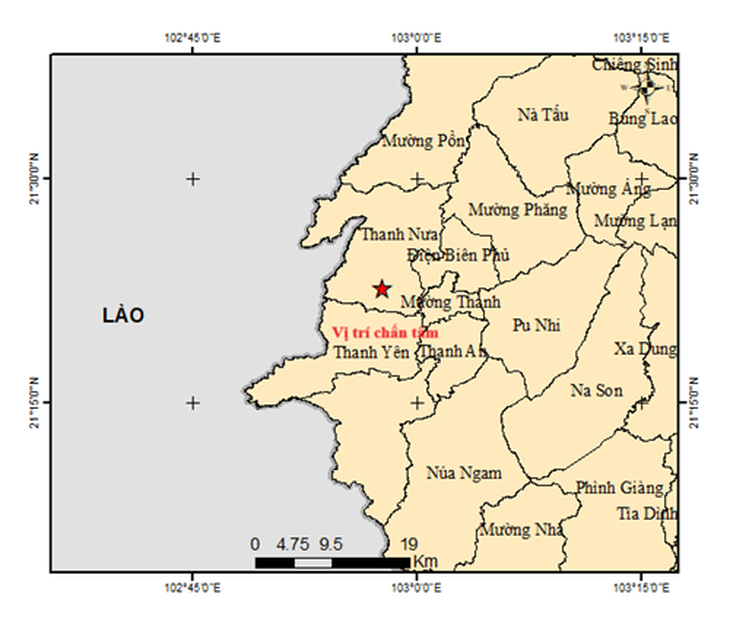
The earthquake occurred in Dien Bien province.
Specifically, at 10:15 AM on July 24th, an earthquake with a magnitude of 3 occurred at coordinates 21.378 degrees North latitude and 102.961 degrees East longitude, with a focal depth of approximately 10.1 km. The earthquake occurred in Thanh Nua commune, Dien Bien province. The natural disaster risk level is 0.
The Earthquake Information and Tsunami Warning Center - Institute of Earth Sciences is continuing to monitor this earthquake.
Earlier on May 16th, two earthquakes, measuring 5 and 4 magnitude, occurred consecutively in the former Muong Cha district (Dien Bien province). The 5 magnitude earthquake was classified as a level 2 natural disaster risk in the area near the epicenter. Many residents in Dien Bien, Son La, and Lao Cai provinces felt the tremors from this earthquake.
According to a preliminary report from the Dien Bien Provincial Steering Committee for Disaster Prevention and Search and Rescue, a 5-magnitude earthquake that occurred on May 16th in Muong Cha district caused cracks in the walls of 8 houses, 4 schools, 1 health station, and 3 offices.
The estimated damage is approximately 1.85 billion VND. On May 23rd, the former Muong Cha district experienced another strong earthquake measuring 3.5 magnitude, but it did not cause any significant natural disaster risks. Dien Bien province is located in the Northwest region, where there are two major seismic fault lines: Dien Bien - Lai Chau and Song Ma - Son La, so earthquakes occur frequently.
According to historical records, very strong earthquakes have occurred in Dien Bien with magnitudes ranging from 5.3 to 6.9 in 1935 (6.9 in the Dien Bien basin), 1983 (6.7 in Tuan Giao town), 2001 (5.3 in Dien Bien Phu city), 2019 (4.3 in Muong Ang district), and 2022 (4.5 in Dien Bien Dong district).
The 5.3 magnitude earthquake in 2001 alone caused approximately 210 billion VND in damage and destroyed many buildings.
Source: https://tuoitre.vn/dong-dat-manh-3-do-tai-dien-bien-2025072411590942.htm


![[Photo] The General Secretary attends the groundbreaking ceremony for the construction of the Truong Ha Primary and Secondary Boarding School.](/_next/image?url=https%3A%2F%2Fvphoto.vietnam.vn%2Fthumb%2F1200x675%2Fvietnam%2Fresource%2FIMAGE%2F2026%2F01%2F28%2F1769604498277_vna-potal-tong-bi-thu-du-le-khoi-cong-xay-dung-cong-trinh-truong-pho-thong-noi-tru-tieu-hoc-va-trung-hoc-co-so-truong-ha-8556822-jpg.webp&w=3840&q=75)


![OCOP during Tet season: [Part 3] Ultra-thin rice paper takes off.](/_next/image?url=https%3A%2F%2Fvphoto.vietnam.vn%2Fthumb%2F402x226%2Fvietnam%2Fresource%2FIMAGE%2F2026%2F01%2F28%2F1769562783429_004-194121_651-081010.jpeg&w=3840&q=75)


![OCOP during Tet season: [Part 2] Hoa Thanh incense village glows red.](/_next/image?url=https%3A%2F%2Fvphoto.vietnam.vn%2Fthumb%2F402x226%2Fvietnam%2Fresource%2FIMAGE%2F2026%2F01%2F27%2F1769480573807_505139049_683408031333867_2820052735775418136_n-180643_808-092229.jpeg&w=3840&q=75)
![OCOP during Tet season: [Part 1] Ba Den custard apples in their 'golden season'](/_next/image?url=https%3A%2F%2Fvphoto.vietnam.vn%2Fthumb%2F402x226%2Fvietnam%2Fresource%2FIMAGE%2F2026%2F01%2F26%2F1769417540049_03-174213_554-154843.jpeg&w=3840&q=75)


Comment (0)