

In February 1885, among the French expeditionary army marching to occupy Lang Son was Major Hocquard (1853-1911), a military doctor. Besides his main duty of providing medical care, this doctor also had a passion for photography and exploring new lands. During the march, he recorded and photographed many events involving the French expeditionary army, the landscapes, and the people of Lang Son...
Some photographs taken at that time, such as artillery climbing mountain peaks, the entrance to Lang Son citadel, the landscape of Ky Lua, the military medical station located in Ky Lua, the valley and village of Dong Dang, the guard tower at the border gate, etc., were printed in Chapter XIX of the book "Une camparne au Tonkin" (A Campaign in Tonkin), published in France in 1892. These are the first photographs of Lang Son that we know today.
These sharp, timely, and artistic photographs are valuable resources for researching place names, historical sites, economic forms, traditional costumes, customs, and folk architecture of the ethnic groups in Lang Son province. The historical events captured in these images also play a significant role in illustrating the province's written history. |
From then until the successful August Revolution (1945), many photographs of Lang Son were taken by French journalists, officials, and specialized cultural agencies for various purposes. It is evident that Lang Son province has a very large number of photographs taken during this period, with rich and diverse content. The locations for these photographs are mostly concentrated in urban areas – where French troops were stationed in Lang Son, along the transportation route from Huu Lung to Dong Dang.
Today, we see these photographs collected by museums, research institutes, and individuals. The authenticity of the photos is not only based on the information directly written in French on the images but also on comparisons with the current reality. However, many photographs cannot be identified by their exact location, but can be determined by the cultural characteristics, uniqueness, and identity of Lang Son... This provides us with multifaceted perspectives on the memories of Lang Son in the past.
The land and people of Lang Son through photographs.
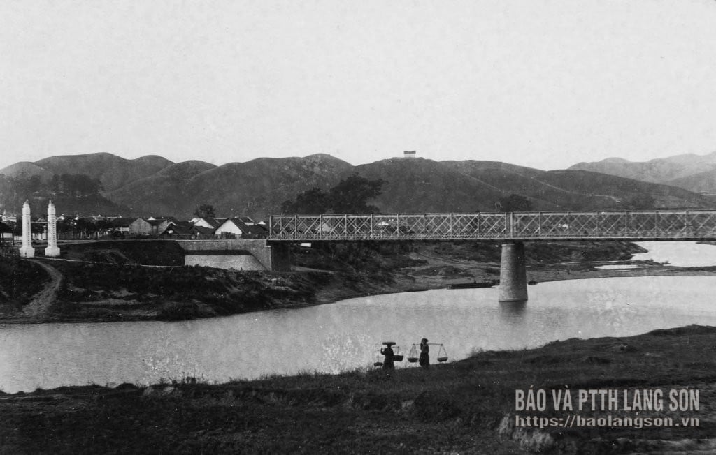
Among the vast collection of photographs of Lang Son from the late 19th and early 20th centuries, we first see images of the landscapes and nature of Lang Son. These include the treacherous, deserted mountain roads leading to Lang Son, Dong Dang, and the Nam Quan Pass. Alongside these are many familiar landmarks of Lang Son province such as: Pho Vi valley, Ky Lua market town, Tam Thanh cave (often called "Ky Lua cave" by the French), the scenery of the Nhi-Tam Thanh mountain area; houses and streets of Lang Son in the area of the French Resident's Residence and the southern part of the provincial capital; the train station, church, and ancient citadel of Lang Son; the Ky Cung bridge and riverbank… We also get a glimpse of the entrance to the ancient citadel of Lang Son, with the faint outline of Thanh Pagoda.
One of the most frequently mentioned places after the provincial capital of Lang Son is Dong Dang. This location is associated with the French management of the border after conquering Lang Son, related to agreements and treaties on the border with China. Therefore, many French officials and soldiers appear in Dong Dang in photographs. The border gate on the Vietnam-China border had watchtowers, and Vietnamese and Qing Dynasty officials and soldiers were on duty guarding the gate. Dong Dang, as seen through the lens of the French, depicts a peaceful valley landscape, villages, secluded mountain roads leading to the Nam Quan Pass, markets, train stations, houses, and barracks of French soldiers stationed on the hills alongside the roads… Besides these two main locations, there are many other places in Lang Son captured by French photographers, but in smaller numbers, such as: the villages, markets and train stations of Bac Le and Than Muoi; the markets and towns of Na Sam and Loc Binh; the That Khe Assembly Hall in Na Sam; Tay ethnic villages in Bac Son…
Upon arriving in Lang Son, driven by curiosity, the French captured numerous images of the people and the unique cultural life of this land. Today, we see photographs of the ethnic minorities of Lang Son: Nung and Dao women; A family or group of children and women of the Tho (Tay) ethnic group in the early 20th century… Alongside these are photos of some historical figures such as Vi Van Ly (Governor of Lang Son) and his son Vi Van Dinh (former Governor of Cao Bang, Hung Yen, Phuc Yen; Governor of Thai Binh, Ha Dong)… Associated with these photos of ethnic groups are images depicting daily life or festivals of the people of Lang Son, such as: scenes of traveling by train from Lang Son to Hanoi, Tay people going to the market, fishermen pulling nets in That Khe, a fisherman's meal, pounding rice with a water mill, theatrical performances, a procession of palanquins by the Chinese during a festival in Ky Lua market in 1896, scenes of Vietnamese and Chinese buying and selling agricultural products, local produce, and consumer goods in markets such as Ky Lua, Na Sam, Bac Le, Dong Dang, Mai Sao…
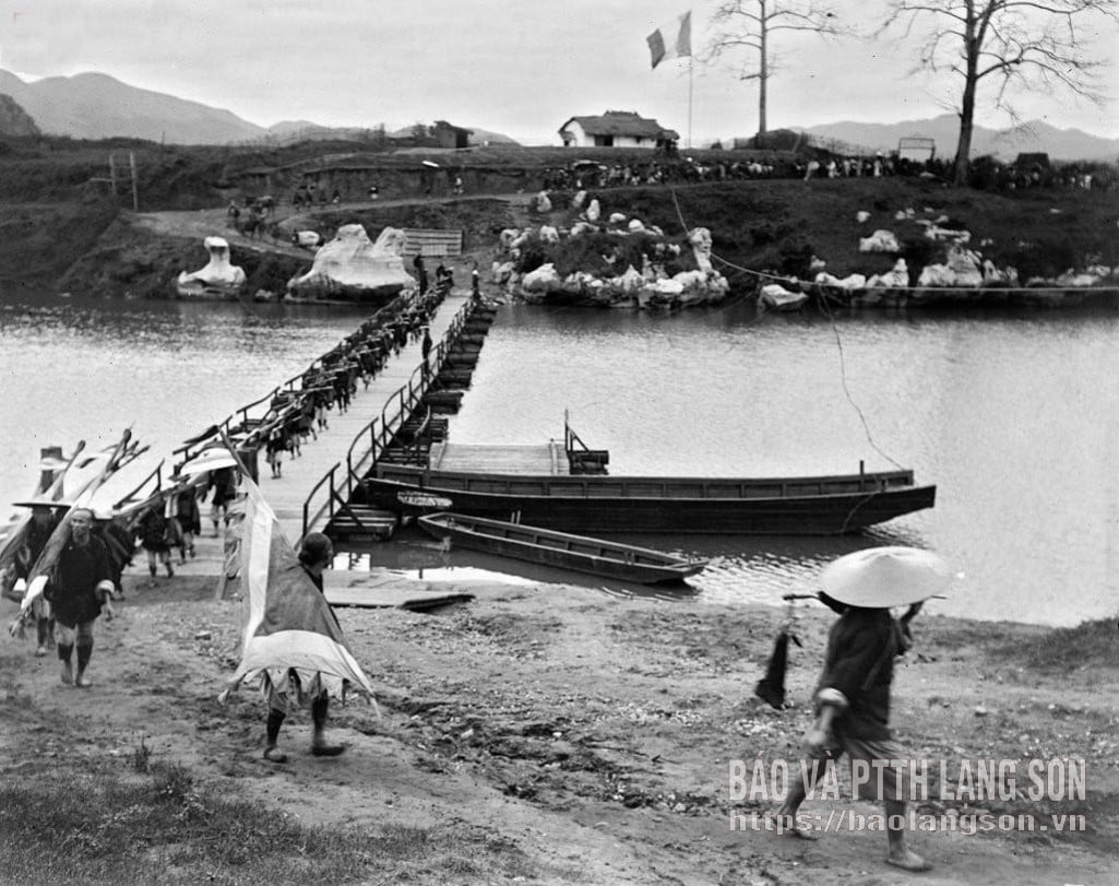
The historical significance is further enhanced by photographs documenting events related to the French military's activities in Lang Son, such as: porters serving French troops during their rest stops, the French military medical station established on Ky Lua Street during the 1885 conquest of Lang Son, the Qing Dynasty (China) ambassador's visit to Lang Son for peace talks after the 1885 Franco-Qing conflict, road and bridge construction in Lang Son at the end of the 19th century, French artillery units stationed at the border, and the Japanese army's entry into Lang Son in September 1940… Particularly noteworthy is a collection of photographs of French officials welcoming General Su Yuanchun, Commander-in-Chief of Guangxi, for talks at the French Resident's residence on June 15, 1896… Alongside these are images of French and Lang Son soldiers and officials within the colonial administration, including interpreters, village elders, soldiers, and cavalry…
These photographs will stand the test of time.
Because they capture reality directly, photographs of Lang Son from the late 19th and early 20th centuries are of multifaceted value, especially as historical documents. Their rarity also lies in the fact that they depict objects that are only mentioned in the photographs and have not been specifically or detailedly described in written documents.
Exactly 140 years have passed since the first photographs appeared. Although the landscape and objects have changed considerably, or even disappeared, today we can still vividly imagine the life of the people of Lang Son in those bygone years, as well as the appearance of the Lang Son region with its mountains and rivers, architecture, temples, shrines, and scenic spots…
These sharp, timely, and artistic photographs are valuable resources for researching place names, historical sites, economic forms, traditional costumes, customs, and folk architecture of the ethnic groups in Lang Son province. The historical events captured in these images also play a significant role in illustrating the province's written history.
Recalling the bygone days, each of us sees more clearly the constant transformation and movement of history, and the great development of the border region of Lang Son. These are also important facts that help in preserving and promoting the value of the province's national cultural heritage today and in the future.
Source: https://baolangson.vn/nhung-buc-anh-ve-mien-dat-con-nguoi-lang-son-cuoi-the-ky-xix-dau-the-ky-xx-5066768.html


Comment (0)