TPO - The meteorological agency forecasts that in July, Ho Chi Minh City will experience several periods of widespread rain, with moderate to heavy, and even very heavy rain occurring in some areas, most likely in the first and last weeks of the month, while the rain is likely to decrease in the middle week of the month.
Forecasts for the first 10 days of July indicate that the Southern region will be primarily influenced by the southern edge of a low-pressure trough at approximately 24-27 degrees North latitude, connected to a gradually weakening hot low-pressure area to the west. Southwest monsoon winds will generally be of moderate intensity. A fairly strong subtropical high-pressure system, with its axis generally at approximately 25-30 degrees North latitude, will also be present.
In Ho Chi Minh City, the first 10 days of the month will see heavy rainfall, ranging from scattered to widespread, with some areas experiencing moderate to heavy rain. Be prepared for tornadoes, strong winds, and lightning strikes during thunderstorms. Heavy rains may cause flooding in the city center. The average temperature will be 0.2-0.4°C higher than the average for the same period. The total weekly rainfall will be approximately 80-150mm, higher than the average for the same period.
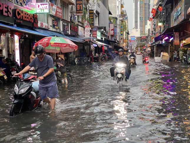 |
Bui Vien Street and many other streets in District 1 (Ho Chi Minh City) were flooded during the rain on the afternoon of June 14th. Photo: Huu Huy |
By the middle 10 days of the month, the area is mainly affected by weak to moderate intensity southwest monsoon winds. The subtropical high-pressure system, with its axis passing through the Central region, is quite active.
The weather in Ho Chi Minh City is generally characterized by scattered showers and thunderstorms, mainly occurring in the late afternoon and evening. Be prepared for possible thunderstorms, strong winds, and lightning. Total rainfall is generally lower than the average for the same period, ranging from 60-120mm. Average temperatures are 0.3-0.5°C higher than the average for the same period.
In the last days of the month, the city area continues to be mainly affected by the southwest monsoon of moderate intensity. At higher altitudes, a subtropical high-pressure system passes through the northern region. The weather in the area will generally be characterized by scattered showers and thunderstorms, with the possibility of moderate to heavy rain in some places. Be prepared for tornadoes, lightning, localized heavy rain, and strong gusts of wind during thunderstorms. Total rainfall will be approximately the same as the average for the same period, generally ranging from 80-150mm. Average temperatures will be 0.2-0.4°C higher than the average for the same period.


The forecast for total rainfall in July 2024 is generally close to the average for the same period. Specifically, the first week of the month will see rainfall approximately 5-15% higher than the average, the middle week will be approximately 5-10% lower than the average, and the last week will generally be 5-15% higher than the average.
"In July, there will be several periods of widespread rain with moderate to heavy, and even very heavy rain in some areas, with a high probability of occurring in the first and last weeks of the month; rain will decrease in the middle of the month. Be prepared for the possibility of thunderstorms, tornadoes, lightning, and strong winds during thunderstorms, which could cause dangerous weather for people, damage property, and disrupt daily life," - the Southern Region Meteorological and Hydrological Station forecasts.


Source: https://tienphong.vn/tphcm-don-nhieu-dot-mua-lon-dien-rong-post1651284.tpo


![[Video] Weather forecast for tonight and tomorrow, July 4, 2026: The remnants of Typhoon No. 1 will cause widespread and prolonged heavy rain in Northern Vietnam.](https://vphoto.vietnam.vn/thumb/402x226/vietnam/resource/IMAGE/2026/07/03/1783083905760_thum-dem-png.webp)