
At 7:00 AM, the typhoon's center was located at approximately 16.1 degrees North latitude and 113.7 degrees East longitude, in the sea east of the Hoang Sa (Paracel) Islands. The strongest winds near the center of the typhoon were at level 8 (62-74 km/h), with gusts up to level 10; it was moving slowly in a west-northwest direction at a speed of about 5-10 km/h.
Forecast of storm developments (over the next 24 to 72 hours)
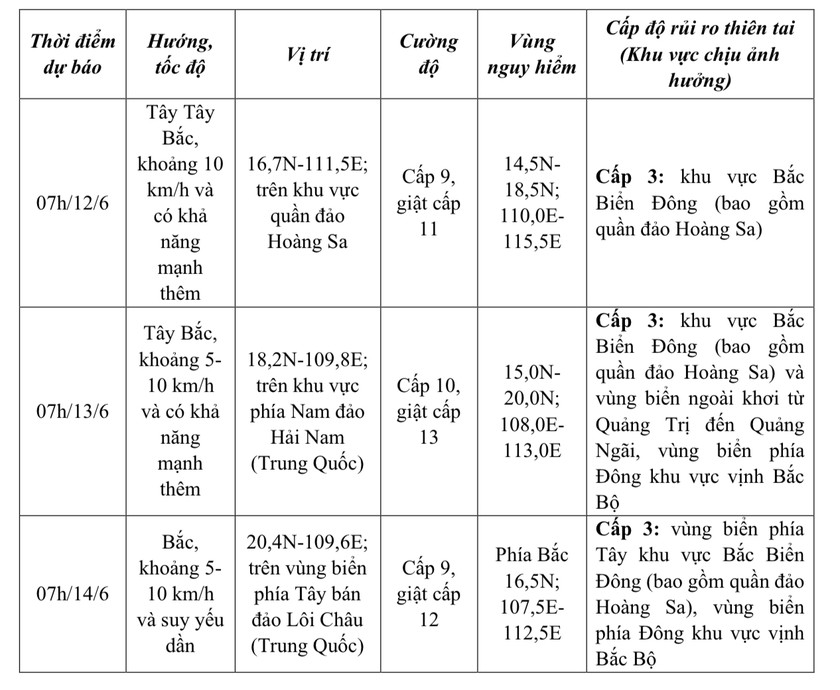 |
Over the next 72 to 120 hours, the storm moved in a north-northeast direction before changing to northeast, traveling at approximately 20 km per hour.
Forecasts indicate that due to the impact of the storm in the northern South China Sea (including the waters around the Hoang Sa archipelago), the northern part of the central South China Sea will experience thunderstorms and strong winds of force 6-7, reaching force 8-9 near the storm's center, with gusts up to force 11, and waves 3.0-5.0m high, with very rough seas; the southern part of the central South China Sea and the southern South China Sea (including the waters around the Truong Sa archipelago) will experience strong southwest winds of force 6, sometimes force 7, with gusts up to force 8-9, and waves 2.0-4.0m high, with rough seas.
Vessels operating in the aforementioned hazardous areas are susceptible to the effects of thunderstorms, tornadoes, strong winds, and high waves.
Source: https://baophapluat.vn/ap-thap-nhiet-doi-da-manh-len-thanh-bao-post551411.html


![[Photo] Prime Minister Pham Minh Chinh receives the Chinese Ambassador to Vietnam](https://vphoto.vietnam.vn/thumb/1200x675/vietnam/resource/IMAGE/2026/04/05/1775397481797_ndo_br_dsc-5512-jpg.webp)


Comment (0)