
 |
| Location and predicted path of Typhoon No. 1. |
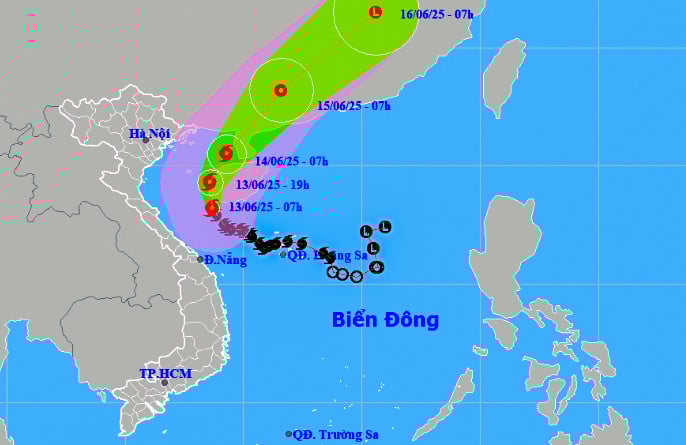
By 7:00 AM on June 14th, the storm was located over the sea east of the northern part of the Gulf of Tonkin, with wind speeds near the center reaching level 10, gusting to level 13. Afterwards, the storm moved towards the north-northeast and gradually weakened into a tropical depression. By June 15th, the tropical depression was located over the southwestern part of Guangdong province (China).
Due to the influence of the storm, in the northwestern part of the North East Sea, the offshore waters from Quang Tri to Da Nang will experience strong winds of force 6-8, reaching force 9-10 near the storm's center, with gusts up to force 13. Sea waves will be 3-5 meters high, and 4-6 meters near the storm's center, resulting in very rough seas. In the Gulf of Tonkin, winds will be strong of force 6-7, reaching force 8-10 near the storm's center, with gusts up to force 13. Sea waves will be 2-4 meters high, and 3-5 meters in the eastern part, resulting in very rough seas.
The Khanh Hoa Meteorological and Hydrological Station warns that the sea area of Khanh Hoa, including the Truong Sa archipelago, will experience showers and thunderstorms, southwest winds of force 5-6, gusts of force 7-8, and waves 1.5-2.5 meters high, with rough seas. Ships in the dangerous area should be aware of the high risk of thunderstorms, tornadoes, strong winds, and high waves.
H.D
Source: https://baokhanhhoa.vn/xa-hoi/202506/bao-so-1-giat-cap-13-dan-suy-yeu-95977ef/

![[Photo] Prime Minister Pham Minh Chinh receives the Chinese Ambassador to Vietnam](https://vphoto.vietnam.vn/thumb/1200x675/vietnam/resource/IMAGE/2026/04/05/1775397481797_ndo_br_dsc-5512-jpg.webp)


Comment (0)