
According to the National Center for Meteorological and Hydrological Forecasting, Typhoon No. 4 , internationally named Comay (the name given by Vietnam), had its center at 13:00 at 16.3°N; 118.7°E, in the eastern part of the North East Sea. The typhoon had an intensity of level 9–10 (75–102 km/h), with gusts up to level 12.
The storm is currently moving in an east-southeast direction at a speed of approximately 10 km/h.
Typhoon No. 4 is at level 9-10, meaning winds of 75-102 km/hour, with gusts up to level 12, and is moving southeast at a speed of approximately 10 km/hour.
Due to the influence of Typhoon No. 4, the eastern part of the northern South China Sea is experiencing strong winds of force 7-8, with winds near the center of the typhoon reaching force 9-10, gusting to force 12. Sea waves are 4-6 meters high. The sea is very rough. Therefore, vessels operating in this dangerous area are at high risk of encountering thunderstorms, tornadoes, strong winds, and high waves.
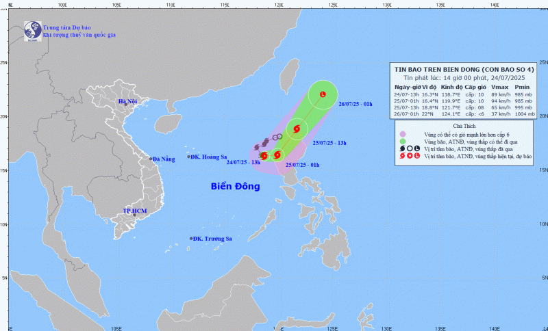
Over the next 12 hours, the storm will change direction, moving eastward at a speed of approximately 10 km/h. By 7 PM tonight, the storm's center will still be located in the eastern part of the North East Sea, with wind speeds of force 9-10, gusts up to force 12, and a tendency to turn back towards the Northwest Pacific Ocean.
Over the next 12 hours, the storm will move northeast, increasing its speed to 20-25 km/h. By 7 AM tomorrow (July 25th), the storm's center will be located north of Luzon Island (Philippines), with wind speeds of level 8, gusting to level 10, and will have moved out of the South China Sea.
Around 7:00 AM on July 26th, the storm maintained its northeasterly direction of movement at 25-30 km/h, gradually weakening into a low-pressure area.
Although unlikely to directly affect mainland Vietnam, Typhoons Comay could cause strong winds and high waves in the eastern part of the North East Sea, with wind speeds of force 7-8, near the center of the storm reaching force 9-10, gusting to force 12; sea waves reaching 4-6 meters in height. The sea will be very rough.
Vessels operating in the aforementioned hazardous areas are susceptible to the effects of thunderstorms, tornadoes, strong winds, and high waves.
According to the National Center for Meteorological and Hydrological Forecasting, this year's typhoon season in the Northwest Pacific region is very active. Immediately after typhoon number 3, this sea area is experiencing three typhoons simultaneously.
Specifically, Typhoon Comay was at longitude 118, Typhoon Francisco at longitude 128, and Typhoon Krosa at longitude 140 degrees east.
Earlier, at 10:30 AM on July 24th, the tropical depression located at approximately 140 degrees east longitude strengthened into a typhoon, internationally named Typhoon Krosa.
Forecasts indicate that Typhoon Krosa will move northward and not enter the South China Sea, therefore the National Center for Meteorological and Hydrological Forecasting will not issue a warning about this typhoon.
Source: https://cand.com.vn/Xa-hoi/-bao-so-4-manh-cap-10-doi-huong-lien-tuc--i775855/


Comment (0)