
(ĐCSVN) – Hồi 10 giờ ngày 8/11, vị trí tâm bão bão số 7 (Yinxing) ở trên vùng biển phía Đông của khu vực Bắc Biển Đông, với sức gió mạnh cấp 13-14, giật cấp 17, di chuyển theo hướng Tây Tây Nam, tốc độ khoảng 15km/giờ.
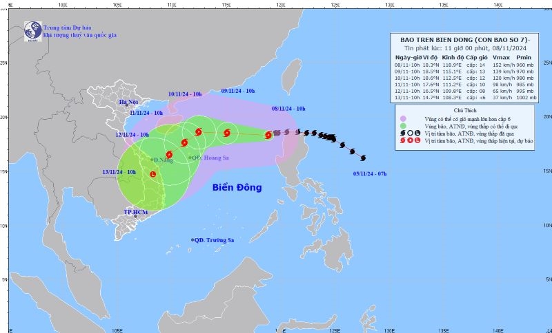 |
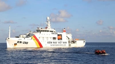
| Vị trí và hướng đi của bão số 7 vào chiều 8/11. Ảnh: TT KTTV |
Theo Trung tâm Dự báo Khí tượng thủy văn Quốc gia, hồi 10 giờ (08/11), vị trí tâm bão ở vào khoảng 18,3 độ Vĩ Bắc; 118,9 độ Kinh Đông, trên vùng biển phía Đông của khu vực Bắc Biển Đông. Sức gió mạnh nhất vùng gần tâm bão mạnh cấp 13-14 (134-166km/h), giật cấp 17. Di chuyển theo hướng Tây Tây Nam, tốc độ khoảng 15km/h.
Hồi 10 giờ ngày 09/11, vị trí tâm bão ở vào khoảng 18,5 độ Vĩ Bắc; 115,1 độ Kinh Đông, trên khu vực Bắc Biển Đông, cách quần đảo Hoàng Sa 430km về phía Đông Bắc. Sức gió mạnh nhất vùng gần tâm bão mạnh cấp 12, giật cấp 15. Di chuyển theo hướng Tây Tây Bắc, tốc độ khoảng 15-20km/h.
Hồi 10 giờ 10/11, vị trí tâm bão ở vào khoảng 18,6 độ Vĩ Bắc; 11259 độ Kinh Đông, cách quần đảo Hoàng Sa khoảng 270km về phía Bắc Đông Bắc. Sức gió mạnh nhất vùng gần tâm bão mạnh cấp 12, giật cấp 15. Di chuyển theo hướng Tây Tây Bắc, tốc độ khoảng 10km/h và suy yếu dần.
Hồi 10 giờ 11/11, vị trí tâm bão ở vào khoảng 17,6 độ Vĩ Bắc; 111,2 độ Kinh Đông, cách quần đảo Hoàng Sa khoảng 140km về phía Bắc Tây Bắc. Sức gió mạnh nhất vùng gần tâm bão mạnh cấp 10, giật cấp 13. Di chuyển theo hướng Tây Nam, tốc độ khoảng 5-10km/h.
Từ 72 đến 120 giờ tiếp theo, bão di chuyển theo hướng Tây Nam, mỗi giờ đi được 10-15km, cường độ tiếp tục suy yếu thêm.
Do ảnh hưởng của bão, đêm 8 và ngày 9/11, khu vực Bắc Biển Đông (bao gồm vùng biển Hoàng Sa) gió mạnh cấp 7-9, vùng gần tâm bão đi qua mạnh cấp 10-12, giật cấp 14, biển động dữ dội; sóng biển cao từ 4-6m, vùng gần tâm bão 6-8m.
Vùng biển phía Bắc khu vực giữa Biển Đông và vùng biển từ Quảng Trị đến Cà Mau gió Đông Bắc mạnh cấp 5, có lúc cấp 6, giật cấp 7-8; biển động; sóng biển cao từ 2-5m. Độ rủi ro thiên tai do gió mạnh trên biển cấp 2. Riêng vùng biển phía Đông của khu vực Bắc Biển Đông cấp 4. Toàn bộ tàu thuyền hoạt động trên các khu vực trên đều có nguy cơ cao chịu tác động của lốc xoáy, gió mạnh và sóng lớn./.
Nguồn: https://dangcongsan.vn/xa-hoi/bao-yinxing-giat-cap-17-chuyen-huong-tay-tay-nam-682693.html


Bình luận (0)