
Creating corridors to protect the value of water resources.
Rapid urbanization in recent years is creating increasing pressure on natural land resources. Many ponds and lakes, once considered "empty land," are at risk of being filled in to make way for infrastructure and residential areas. However, behind each shrinking area of water surface also lie environmental consequences that are difficult to remedy in the short term.
When water bodies are filled in, their natural drainage capacity is significantly reduced, leading to an increased risk of flooding, especially in the context of increasingly frequent extreme rainfall events. Furthermore, the loss of these natural "water reservoirs" also lowers groundwater levels, directly affecting water resources for domestic and industrial use, and disrupts the ecosystems associated with these water bodies, resulting in a decline in biodiversity.
In this context, the province recently issued a list of 16 lakes, ponds, swamps, and lagoons that are not allowed to be filled in, signifying the establishment of a "protective belt" for water resources. This is not only an administrative decision but also a strategic step to preserve these "natural regulating reservoirs"—a crucial element in ensuring sustainable development.
Furthermore, lakes and ponds are home to many species of organisms, from fish and shrimp to waterbirds and aquatic plants. Protecting these water bodies means maintaining biodiversity, preserving natural balance, and is a core foundation for sustainable development. The published list also demonstrates a comprehensive approach. It includes not only large-scale irrigation projects but also extends to medium-sized regulating lakes, small ponds in residential areas, and natural pools associated with cultural life. All are recognized as indispensable links in the local aquatic ecosystem.
Notably, many local residents expressed their agreement with this policy. Mr. Nguyen Van Phuong, a resident living near the regulating ponds in Long An ward, shared: “Keeping the ponds and lakes helps the water drain faster during heavy rains, and the environment is also cooler. People support the province's recent policy of not filling in the ponds and lakes.”
Sharing the same view, Ms. Le Thi Huong, a resident of Phuoc Ly commune, said: “Some ponds in the locality have existed for many years; they are not only water reservoirs but also closely connected to the lives of the people. Preserving these ponds means preserving both the living environment and the memories of our homeland. To protect the water sources in these ponds and lakes, the government needs to intensify propaganda to encourage people not to discharge waste or litter that pollutes the water sources.”
Towards effective water resource management.

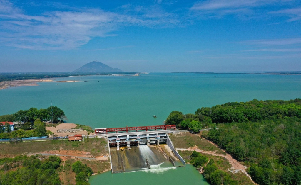
According to Vice Chairman of the Provincial People's Committee Nguyen Minh Lam, among the list of lakes, ponds, swamps, and lagoons that are not allowed to be filled in, the most prominent is Dau Tieng Lake with an area of over 20,107 hectares (part of which is located in Tay Ninh province). This is a strategic irrigation project, playing a particularly important role in supplying water for agricultural production, industry, and daily life. Furthermore, the lake also performs the function of regulating water flow on a large scale: storing water during the rainy season, regulating its use during the dry season, and contributing to stabilizing water resources for a vast region. At the same time, Dau Tieng Lake also creates ecological landscapes, preserves biodiversity, and acts as a "water lung" regulating the environment.
Next is Tha La Lake, with an area of over 2,254 hectares, playing a crucial role in supplying water for production and daily life. This is one of the projects that contributes to ensuring water security in the face of increasingly complex weather conditions.
In addition, the Suoi Duc dam in Tan Dong commune, with an area of 249 hectares, is also identified as an essential water regulation, storage, and supply project for the area. On a medium scale, the Nuoc Trong reservoir, with an area of over 332 hectares, clearly demonstrates the "multifunctional" nature of water bodies: regulating rainwater, preventing and controlling flooding, and contributing to improving the living environment. In the context of increasing extreme weather events, such regulating reservoirs become an important "line of defense" to help minimize the risks of natural disasters.
In urban areas, small ponds, seemingly modest in size, hold special significance. The ponds in Binh Yen Dong 1 neighborhood (over 3.3 hectares) and Quan Pond (over 1.7 hectares) in Long An ward are preserved to serve water supply, drainage, and microclimate regulation. Ba Ken Pond (1.6 hectares) in Kien Tuong ward also serves to prevent flooding, create a scenic landscape, and improve the urban environment. These "water features" help residential areas improve their ability to cope with heavy rainfall, minimizing the risk of flooding – a growing challenge in the urbanization process.
Beyond their environmental value, many small ponds are closely intertwined with the cultural and religious life of the local people. Ponds such as Uong Pond (0.05 ha) in Can Giuoc commune, Tram Bau Pond (over 0.08 ha), Me Pond (over 0.07 ha), and Dong Pond (over 0.07 ha) in Phuoc Ly commune have been identified as having the function of protecting and preserving religious and spiritual activities. These are special spaces where nature blends with spiritual life, contributing to the preservation of local cultural identity through generations. Including these ponds in the list of protected areas demonstrates a harmonious approach to development between economy , environment, and culture.
In addition, natural ponds such as Vuong Pond (2.63 ha), Ong Tao Pond (0.94 ha), and Nang Pond (2.56 ha) in Long Chu commune not only serve as water reservoirs but also hold profound historical and cultural value. These are "witnesses" of time, closely linked to the memories and lives of many generations of people.
Notably, the list also includes excavated pits and open-pit mines after land reclamation, such as the 7-meter cluster pit (over 2.7 hectares) in Nhon Hoa Lap commune and the Tan Long flood-resistant residential area pit (over 1.8 hectares) in Nhon Ninh commune. Including these areas under protection not only helps utilize water resources but also demonstrates a flexible transformation mindset: turning areas previously used for mining into resources that serve the environment and daily life. Many residents also believe that utilizing these excavated pits as water reservoirs is a logical approach.
It is evident that, from large-scale reservoirs to small ponds in residential areas, all contribute to a complete aquatic ecosystem. Each water body is a "link" in the chain, and only when these "links" are protected synchronously can the system operate sustainably. In the context of increasingly complex climate change, with droughts, saltwater intrusion, and flooding tending to worsen, preserving the "water map" is no longer an option but a necessity. This is not only an immediate task but also a long-term strategy for future development.
Alongside establishing the list, the province also set out a strict management mechanism. Specifically, the Department of Agriculture and Environment is responsible for organizing the publication of the List of lakes, ponds, swamps, and lagoons that are not allowed to be filled in within the province to relevant departments, agencies, commune and ward People's Committees, organizations, and individuals, through mass media, and updating it into the national water resources information system and database as prescribed. It will also lead and coordinate with relevant departments, agencies, and commune-level People's Committees to review and advise the Provincial People's Committee on adjustments and additions to the List of lakes, ponds, swamps, and lagoons that are not allowed to be filled in within the province periodically every 5 years or when necessary. The People's Committee at the commune level is responsible for disseminating information and raising awareness among the local community about not discharging untreated wastewater into lakes, ponds, swamps, and lagoons, causing water pollution. They are also prohibited from arbitrarily filling in or renovating lakes, ponds, swamps, and lagoons listed in the province's prohibited-to-fill list. Furthermore, they are responsible for monitoring, inspecting, and promptly detecting cases of violations and misuse of lakes and ponds listed in the province's prohibited-to-fill list. |
Source: https://baotayninh.vn/giu-gin-ban-do-nuoc-cho-phat-trien-ben-vung-142555.html


Comment (0)