
 |
| Tham Ma Pass, National Highway 4C, is located in Pho Bang commune. |
Tham Ma Pass is located on National Highway 4C, also known as the legendary Happiness Road. According to locals, the pass stretches for more than 2 km, with the highest point in Mo Xi hamlet being the most beautiful winding bend, a test of human endurance, horse strength, and even... car power. When talking about the mountainous region of Ha Giang (now Tuyen Quang) , people will think of challenges such as the Bac Sum Pass, Ma Pi Leng Pass, and, of course, Tham Ma Pass, which is located at an altitude of 1,400-1,500m above sea level.
The name Tham Ma (meaning "testing the strength of horses") carries a very figurative meaning. According to the elders in the Stone Plateau, before National Highway 4C was built, the only way to cross this area was by footpaths. Merchants traveling from the lowlands could only use horses to transport goods and had to cross this pass. Each time crossing the Tham Ma slope was a great challenge for both people and horses. Although the road through Tham Ma was treacherous and difficult, it was the only route to Dong Van, the center of the Stone Plateau at one time. There was no other choice; the strength of people and horses had to conquer this slope. To commemorate the difficulty of the slope, it was given a name that sounds very "heavy" – Tham Ma (meaning "testing the strength of horses").
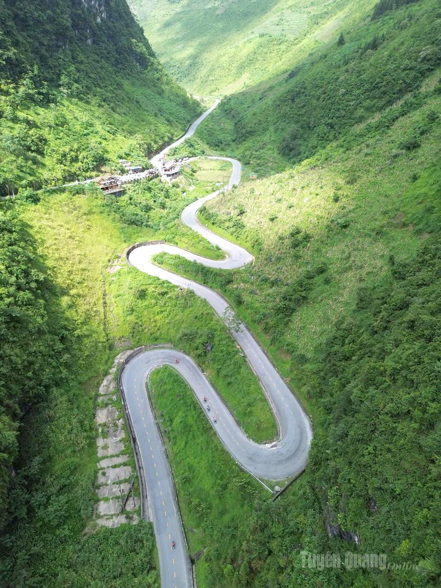 |
| The curves of Tham Ma Pass, viewed from above, are as gentle as a silk ribbon. |
In the 1960s, National Highway 4C was opened through the Tham Ma slope, one of the most arduous and difficult sections of the entire 185-meter-long Happiness Road. It took a great deal of effort and time to complete the Tham Ma slope section. But even after improvements over time and its current beautiful appearance, this slope remains a challenge for many trucks carrying goods to the highlands. Especially for trucks carrying construction materials, many have broken down halfway up the slope due to the sharp curves and steep incline of Tham Ma. Therefore, the beauty of this slope is perhaps only superficial; it remains one of the most challenging slopes in the rocky plateau region, ready to test even the most modern gasoline-powered "workhorses."
Despite the arduous climbs and steep slopes, Tham Ma Pass is truly one of the most magnificent scenic spots on the Stone Plateau. During the dry season, it's covered in a gray blanket of rocks; in summer, it's lush green with corn and various plants. Autumn and early winter, particularly October and November, are the most beautiful months, and are often the most popular with tourists. The vastness and grandeur of the mountains and sheer cliffs make one feel small in the face of this expansive and untamed nature. The smiles, sparkling eyes, and rosy cheeks of the mountain girls captivate visitors. Therefore, many young couples and domestic and international backpacking groups love and never miss this romantic spot.
 |
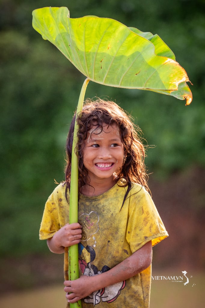
| Tourists take photos at Tham Ma slope with Hmong children. |
Amidst the gray rocky landscape, there are dry seasons that bring barrenness and harshness, but it is the winding shapes of the Tham Ma slope, along with the borderland sky, that make the scenery here gentle and captivating to visitors. Often, the place is packed with tourists, some even likening it to a "collapse" due to the overwhelming number of visitors. But in reality, this is a joy, a happy scene for countless people who get to stand in this "collapsed" space where nature and humanity blend together, and immerse themselves in the majestic beauty of this slope.
For generations, Tham Ma has been a place of hardship, but now it has become a fascinating and romantic destination, offering stunning photos of tourists with young women carrying baskets of wildflowers, buckwheat, and mustard flowers; and countless happy moments of couples captured in frames with the national flag alongside the gentle, silken curves of Tham Ma. This once arduous slope in the impoverished countryside has now become a stopping point for young couples from all over the country and the world .
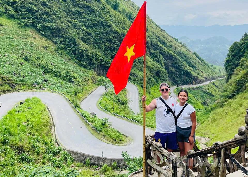 |
| Tham Ma Pass is also a favorite spot for foreign tourists. |
There's an interesting spot on the Tham Ma slope where you can easily find one of the most unique farming practices in Vietnam: cultivating crops in rocky crevices. The Hmong people here diligently clear the land, carrying baskets of soil into the crevices, planting corn, pumpkin, and bean seeds, and then tending to them until harvest. The simple, productive life of the people contributes to the creation of unique heritage on the rocks. Right at the top of the Tham Ma slope, there's a place many people enjoy trying their hand at: the "illusory cliff," a geological formation that creates an illusion. A gorge seems to stretch between two cliffs, and everyone thinks they can easily throw a stone across, but almost no one can throw a stone to the other side.
A simple slope, just two words – Tham Ma – creates so many interesting and unique experiences, both real and surreal, captivating and evoking a multitude of emotions in people's hearts. I and many others have been here many times, but we will certainly want to return to this majestic slope many more times.
Text and photos: Huy Toán
Source: https://baotuyenquang.com.vn/van-hoa/du-lich/202511/hung-vi-doc-tham-ma-tren-mien-da-20c49cf/


Comment (0)