
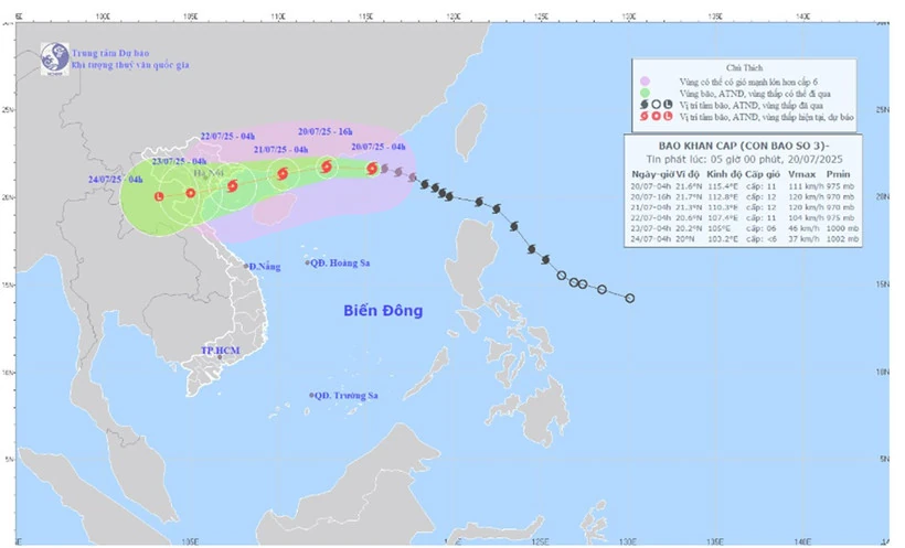
Map showing the predicted path and intensity of Typhoon No. 3, released at 5:00 AM on July 20th. (Image: National Center for Meteorological and Hydrological Forecasting)
The strongest winds near the center of the storm are at level 11 (103-117 km/h), with gusts up to level 14; it is moving in a west-northwest direction at a speed of approximately 20-25 km/h.
Forecast of storm developments ( next 24 to 72 hours):
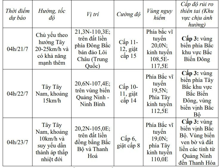
Forecasts indicate that over the next 72 to 96 hours, Typhoon No. 3 will mainly move in a west-southwest direction, traveling at 5-10 km per hour and continuing to weaken.
From the night of July 20th, the northern part of the Gulf of Tonkin (including the special economic zones of Bach Long Vi, Co To, and Cat Hai) will experience increasingly strong winds, reaching levels 6-7, then increasing to levels 8-9, and reaching levels 10-11 near the storm's center, with gusts up to level 14. Sea waves will be 2-4 meters high, and 3-5 meters near the storm's center. The sea will be extremely rough.
From July 21st, the southern part of the Gulf of Tonkin will experience increasingly strong winds, reaching levels 6-7, with winds near the storm's center reaching levels 8-9, gusting to level 11, and waves 2-4 meters high. The sea will be very rough.
Vessels operating in the aforementioned hazardous areas are susceptible to the effects of thunderstorms, tornadoes, strong winds, and high waves.
On land: From the evening and night of July 21st, strong winds will gradually increase to level 7-9, gusting to level 10-11, over the land area from Quang Ninh to Thanh Hoa; further inland, winds will be strong at level 6-7, gusting to level 8-9; near the center of the storm, winds will reach level 10-11, gusting to level 14.
From July 21st to July 23rd, the Northern and North Central regions of Vietnam are likely to experience widespread heavy rainfall with common amounts of 100-200mm, and in some areas exceeding 300mm. Specifically, the Northeast region, the Northern Delta, Thanh Hoa, and Nghe An will experience heavy to very heavy rainfall with common amounts of 200-350mm, and in some areas exceeding 600mm.
Warning of high rainfall risk (>150mm/3 hours).
Source: nhandan.vn
Source: https://baophutho.vn/tin-khan-cap-ve-con-bao-so-3-236419.htm

![[Image] "Journey of Hope" promotes the organ and tissue donation movement in Vietnam.](https://vphoto.vietnam.vn/thumb/1200x675/vietnam/resource/IMAGE/2026/05/20/1779294400833_1-8910-jpg.webp)
![[Photo] National Assembly Chairman Tran Thanh Man working with the Standing Committee of the National Assembly's Delegation Affairs Committee.](https://vphoto.vietnam.vn/thumb/1200x675/vietnam/resource/IMAGE/2026/05/20/1779294340023_ndo_br_1-1691-jpg.webp)

![[Photo] General Secretary and President To Lam works with the Party Committee of the Ministry of Health on the work of Vietnamese traditional medicine.](https://vphoto.vietnam.vn/thumb/1200x675/vietnam/resource/IMAGE/2026/05/20/1779294323718_a1-bnd-2978-3319-jpg.webp)


Comment (0)