Researcher Bui Van Tieng, Chairman of the Da Nang City Historical Science Association, used the term "parallel verse" to refer to An Hai citadel located on the right bank of the Han River in the "complete parallel verse" composed of Dien Hai citadel on the left bank. An Hai citadel still has quite clear traces.
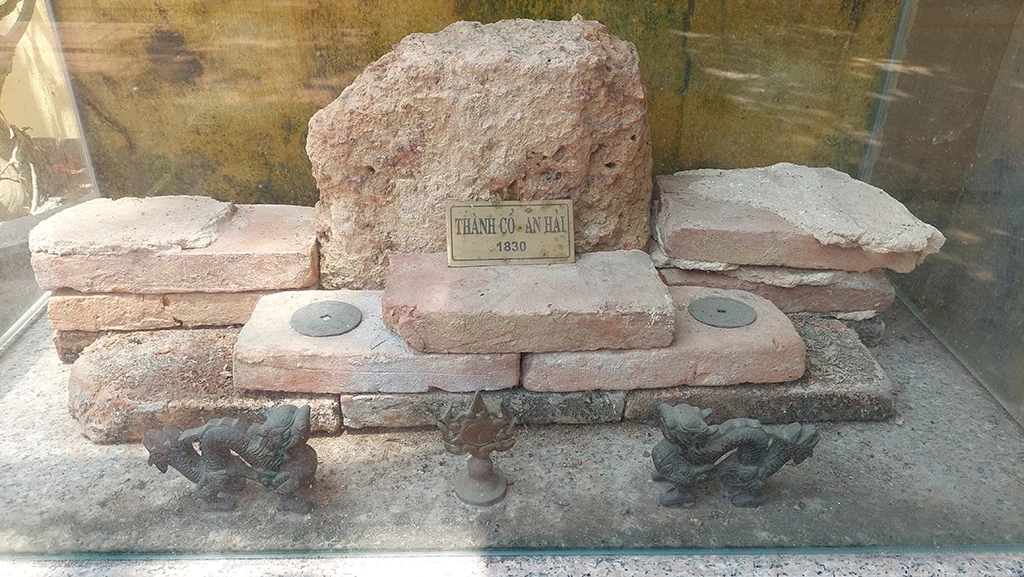
Bricks, stones and ancient coins displayed at the temple of Ba Than Ha Xu (in the coastal village of An Don) are believed to have originated from An Hai citadel.
TOP IMPORTANT DEFENSIVE PROJECT
Researcher Nguyen Quang Trung Tien, former Head of the History Department - Hue University of Sciences, has painstakingly researched, compared documents and provided an excerpt of the locations of the defensive structures around Da Nang Bay based on the map of the Tu Duc Dynasty confiscated by the French at the Quang Nam military headquarters (September 15, 1859). From this excerpt, Mr. Tien continued to number the locations from 1 to 17; in which the location of An Hai citadel is numbered 11, located almost symmetrically with Dien Hai citadel on the left bank of the Han River.
According to this researcher, An Hai citadel is located close to the sea, on the downstream right bank of the Han River, built with earth in 1813, called An Hai fortress; in 1830, it was converted to brick, renamed An Hai castle; in 1834, it was upgraded and called An Hai citadel. An Hai citadel is 1 truong 2 thuoc high, surrounded by a 1 truong deep moat, 41 truong 2 thuoc in circumference, with 2 gates, 1 flagpole and 22 forts. An Hai citadel and Dien Hai citadel form two of the most important military structures in the Da Nang seaport defense system.
Mr. Bui Van Tieng analyzed that the name of Dien Hai citadel does not evoke any association with the place where this ancient citadel is located, but the name of An Hai citadel can evoke association with An Hai village (Thoai Ngoc Hau's hometown). Thus, An Hai citadel is first located in An Hai village (according to the administrative boundary of Quy Dau year 1814, Gia Long 12th year). Second, An Hai citadel has a function that Dien Hai citadel does not have, which is to directly observe ships entering and leaving Da Nang seaport, including: counting the number of ships entering and leaving, classifying the nationality of each ship and showing it by the color of the flag on the citadel's flagpole.
"But to do that, An Hai citadel must be located near the Da Nang bay, at the end of the river, at least at the same latitude as Dien Hai citadel. In the map of Da Nang defense system during the Nguyen dynasty provided by researcher Vo Van Dat, An Hai citadel is determined to be slightly more towards Da Nang bay compared to Dien Hai citadel. This determination is correct," Mr. Tieng commented.
X DETERMINING RELATIVE POSITION
According to Mr. Bui Van Tieng, research shows that 4 years after the French-Spanish coalition withdrew from Da Nang (1860), An Hai citadel was changed to An Hai fort to reduce the burden of troops and equipment and continued to be considered by the Nguyen Dynasty as an important defensive position in the Da Nang seaport defense system. So when did An Hai fort disappear? Until now, this question still has no answer.
Based on the map, related documents as well as suggestions from researchers, we conducted a survey and tried to find traces of An Hai citadel after the hidden period of the past 200 years. In Da Nang city, on the right bank of the Han River, close to the estuary, there still exists the place name An Hai associated with 3 ward names, including: An Hai Bac, An Hai Dong, An Hai Tay. In which, based on map number 11 of An Hai citadel, the location of this ancient citadel is most likely located in the area of An Don village (with a frontage facing the Han River on Tran Hung Dao street, near the Han River bridge).
During our field research, we visited the sacred Ba Than Ha Xu Temple of the An Don fishing village and witnessed a small glass cabinet containing many large bricks and two ancient coins placed right in the temple grounds. According to documents, in 1830, An Hai was still called a tower and had not been upgraded to a citadel and was built of bricks. Many local residents said that many years ago, during the process of building houses, some households discovered ancient bricks and brought them to the temple for display. Mr. Huynh Dinh Quoc Thien, Director of the Da Nang Museum, said that the fishing village area where Ba Than Ha Xu Temple is located is believed to be near the location of An Hai citadel.
Mr. Bui Van Tieng said he had suggested organizing high school students and history students to participate in the activity of "finding lost red addresses" to search through archives and conduct field surveys to determine the specific locations of defensive bases from the same period as Dien Hai citadel that no longer have any traces, such as An Hai citadel in Son Tra district, considering this as a basis for the city's relic management agency to erect a memorial stele.
Mr. Tieng believes that whether or not the exact location of An Hai citadel can be determined, future generations can still behave appropriately towards their ancestors by relying on the two principles mentioned above along with the map provided by researcher Vo Van Dat to determine a relative and suitable location for promotion in order to erect a memorial stele about An Hai citadel. (continued)
Defense system of 17 structures in Danang Bay
According to researcher Nguyen Quang Trung Tien, the defensive belt in Da Nang Bay under the Nguyen Dynasty was a continuous system of 17 structures built at different times, from the reign of King Gia Long in the early 19th century to 1857, the beginning of King Tu Duc's reign. The starting point was Phong Hoa Dai (fire tower) in the east of the bay, the end point was Dinh Hai fortress in the west of the bay (numbered from 1 to 17 on the map at the beginning of King Tu Duc's reign).
Source link















Comment (0)