
 |
| Illustration: Bich Lien |
On the afternoon of November 5, the National Center for Hydro-Meteorological Forecasting said that cold air has affected the North Central region, some places in the Northwest and Central Central regions; at Bach Long Vi station, there are strong Northeast winds of level 6, gusting to level 7.
Forecast on land at night (November 5), cold air continues to affect other places in the Northwest and Central Central regions. Northeast wind inland is strong at level 2-3, coastal areas at level 3-4.
In the Northeast and North Central regions, the weather is cold, and in some mountainous areas of the North, it is cold. The lowest temperature during this cold air mass in the North and North Central regions is generally from 19-21 degrees Celsius, and in some mountainous areas, it is below 16 degrees Celsius.
Hanoi area has rain in some places; cold weather with the lowest temperature commonly 19-21 degrees Celsius.
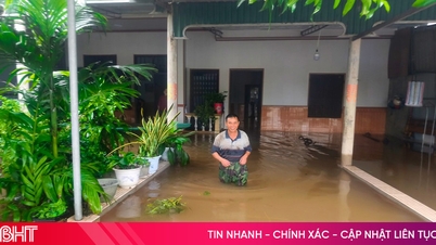
In addition, due to the influence of disturbances in the upper easterly wind zone combined with the strengthening of cold air, the area from Ha Tinh to Binh Dinh will have widespread heavy rain and thunderstorms. During thunderstorms, there is a possibility of tornadoes, lightning and strong gusts of wind.
Experts note that thunderstorms accompanied by tornadoes, lightning and strong gusts of wind can affect agricultural production, cause trees to fall, damage houses, traffic works and infrastructure. Heavy rain and localized heavy rain can cause flooding in low-lying areas; flash floods on small rivers and streams, and landslides on steep slopes.
At sea, in the Gulf of Tonkin, on the night of November 5 to November 6, strong northeast wind at level 5, sometimes level 6, gusting to level 7-8; rough sea; waves from 1.5-3.0m high. In the North East Sea area (including the sea area of Hoang Sa archipelago), strong northeast wind at level 6-7, gusting to level 8-9; rough sea; waves from 4.0-6.0m high. In the sea area from Quang Tri to Binh Dinh, the sea area north of the Central East Sea area, strong northeast wind at level 6, gusting to level 7-8; rough sea; waves from 2.0-4.5m high.
Strong winds and large waves at sea are likely to affect boat operations and other activities.
Central region continues to have heavy rain
The meteorological agency also said that today (November 5), in the area from Ha Tinh to Quang Ngai, there will be moderate rain, heavy rain, and in some places very heavy rain. The rainfall from 7am to 3pm on November 5 was over 140mm in some places such as: Lam Hoa (Ha Tinh) 145.6mm, Dong Tam (Quang Binh) 300.6mm, Thang Binh (Quang Nam) 175.0mm, Dong Nghe Lake Basin (Da Nang) 163.0mm, Loc Tien (Thua Thien Hue) 224.2mm,...
From the evening of November 5 to the morning of November 6, the area from Ha Tinh to Binh Dinh will have heavy to very heavy rain with rainfall from 50-120mm, locally over 300mm. Warning of the risk of local heavy rain (>100mm/3h).
From noon on November 6 to the end of November 7, the area from Quang Tri to Khanh Hoa will have moderate rain, locally heavy rain, some places very heavy rain with rainfall from 40-100mm, some places over 200mm. Warning of the risk of local heavy rain (>100mm/6 hours).
In addition, on the night of November 5 and November 6 in Ninh Thuan, Binh Thuan, the Central Highlands and the South, there will be scattered showers and thunderstorms, locally heavy rain with rainfall from 15-30mm, locally over 60mm (rain concentrated in the afternoon and evening).
From the night of November 7, heavy rain in the Central region tends to gradually decrease. Thunderstorms may cause tornadoes, lightning and strong gusts of wind./.


![[Photo] Lam Dong: Images of damage after a suspected lake burst in Tuy Phong](https://vphoto.vietnam.vn/thumb/1200x675/vietnam/resource/IMAGE/2025/11/02/1762078736805_8e7f5424f473782d2162-5118-jpg.webp)
![[Photo] President Luong Cuong receives US Secretary of War Pete Hegseth](https://vphoto.vietnam.vn/thumb/1200x675/vietnam/resource/IMAGE/2025/11/02/1762089839868_ndo_br_1-jpg.webp)


Comment (0)