
A dream of riverside planning passed down through generations.
Since the founding of Thang Long Imperial City, the Red River has played a vital role, sustaining generations of people, serving as a bustling trading hub, and witnessing the vicissitudes of nature. Today, Hanoi , with over 160 km of the Red River winding through it, 40 km of which flows entirely within the city, has formed vast stretches of land, creating a rare land reserve in the heart of a rapidly developing urban area.

The story of planning along the riverbanks is not something that only emerged in the 21st century. Since 1954, the first plans have laid the foundation for a long-term vision. Through seven revisions of the Hanoi master plan, each has mentioned the Red River as a key landscape axis and a strategic space for the future. Particularly in 2008, when Hanoi expanded its administrative boundaries, the dream of a riverside city became even clearer in the General Planning for the Construction of the Capital City until 2030, with a vision to 2050.

Not only domestically, the Red River has also attracted the attention of many international organizations. Large-scale projects have successively emerged: from the "Red River Town" project proposed by a Singaporean investor in 1996, to the " Science City" conceived by Indochina Land (USA) in 2005. Particularly, during the period of 2004-2006, the HAIDEP project (Vietnam - Japan) and the planning cooperation between Hanoi and Seoul (South Korea) garnered significant public attention for a considerable time.
These are all very commendable proposals and projects.
- Dr. Dao Ngoc Nghiem, Architect, former Director of the Hanoi Department of Planning and Architecture - a person with many years of experience in planning the Red River -
The rich alluvial plains offer immense potential.
Viewed from above, the land along the Red River resembles a silk ribbon winding around the city, encompassing approximately 5,800 hectares of riverside land, ten times the area of Hoan Kiem District. If properly developed, this area could open up a new urban space, relieving pressure on the old city center.
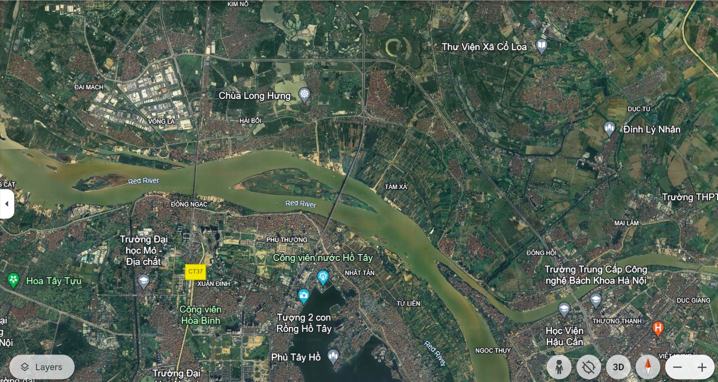

More than just undeveloped land, this area is also home to over 210,000 people and preserves 105 traditional craft village relics. A rich cultural and historical treasure, combined with natural advantages, creates a solid foundation for sustainable urban development.
, an architect, shared with a reporter from Lao Cai Newspaper about the urban planning story along the Red River in Hanoi.")
Based on personal information, these figures were provided by Dr. and Architect Dao Ngoc Nghiem during our conversation. He affirmed that these figures reflect the enormous and valuable potential of the land along the Red River. Therefore, a systematic strategy and comprehensive solution are needed to ensure harmony between development and conservation, between urbanization and disaster prevention and safety.
.")
The Red River – a great mother river, but also one that harbors unpredictable fluctuations. Water levels change erratically, reaching a high of over 13 meters at times and a low of only about 2 meters at others. Significantly, the flow changes approximately every 100 years, creating major shifts in the river's course.
These factors have created numerous obstacles for previous planning projects. There is no comprehensive flood control plan, and the exploitation of riverside land remains a challenging problem. Furthermore, the issue of establishing regional relationships between Hanoi and neighboring provinces needs careful consideration to ensure harmonious development and avoid negative impacts on the overall irrigation system.
Cities on both banks of the river - determined to unlock their potential.
After years of waiting, on March 31, 2022, the Hanoi People's Committee officially approved the Red River Urban Planning Project, at a scale of 1/5000, for the section from Hong Ha Bridge to Me So Bridge. This is not only a legally binding decision but also a milestone demonstrating the government's determination to unlock the potential of this historical river.
.")
This plan covers approximately 30% of the Red River's length through Hanoi, equivalent to 8% of the river's length through the Red River Delta. It's a large-scale project with many complex elements, but if successfully implemented, it will become a breakthrough in urban planning, setting a precedent for other riverside projects nationwide.
Beyond mere blueprints, Hanoi has now implemented comprehensive research on flood control and river flow regulation, drawing on experiences from major cities around the world such as Seoul (South Korea), Paris (France), and Hangzhou (China). Practical lessons from the Han River, Seine River, and Qiantang River will provide crucial insights for Hanoi to realize its dream of a riverside urban area.
With urban planning now in its concrete stages, Hanoi is gradually implementing strategic solutions. The riverside roads will be planned to upgrade existing dikes into major transportation routes, ensuring both flood control and urbanization needs. High-risk residential areas will be relocated according to a schedule, with residents resettled in nearby areas to ensure stable living conditions.
.")
With the approval of the Ministry of Agriculture and Rural Development (now the Ministry of Agriculture and Environment), the plan to build two riverside roads is being carefully studied. The principles of not narrowing flood drainage space, not raising existing dikes, and not constructing new embankments have been established, creating a solid foundation for implementation. Requirements regarding disaster prevention, dike planning, and transportation are all being carefully considered. Developing riverside urban areas is not only an economic issue but also a responsibility to history, culture, and the environment.
Through countless years of ups and downs, the Red River has flowed silently, embracing its fertile alluvial plains and lands rich in potential. Today, Hanoi has laid the first bricks to realize its millennium-long dream – a modern, civilized, and distinctive riverside city.
The Red River is not simply a waterway flowing through the city, but also a source of vitality and a symbol of sustainable development. Once the urban planning challenges are addressed and comprehensive flood control solutions are implemented, a city on both banks of the river will no longer be a distant dream, but a reality, creating a brilliant landmark for Hanoi in the 21st century.
Lesson 5: The Red River Space - A New Symbol of the Capital City
Source: https://baolaocai.vn/bai-4-danh-thuc-tiem-nang-tu-dat-bai-ven-song-post399281.html


![[Photo] Closing Ceremony of the 15th Conference of the Central Committee of the 13th Party Congress](https://vphoto.vietnam.vn/thumb/402x226/vietnam/resource/IMAGE/2025/12/23/1766462841764_a1-bnd-3731-1647-jpg.webp)


Comment (0)