

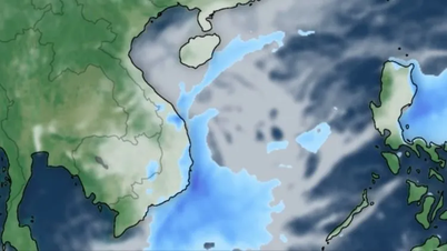
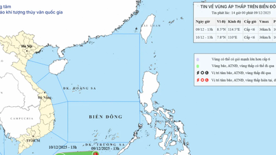
Accordingly, at 7 PM on September 25th, the typhoon's center was located at approximately 11.1 degrees North latitude and 126.7 degrees East longitude, over the sea east of central Philippines. The strongest winds near the center of the typhoon reached level 12 (118-133 km/h), with gusts up to level 15. It was moving in a west-northwest direction at a speed of 20-25 km/h.
Forecasts indicate that by 7 PM on September 26th, the storm's center will be located at approximately 13.2 degrees North latitude and 121.3 degrees East longitude, with wind speeds of level 11, gusting to level 14; moving in a west-northwest direction at a speed of about 25 km/hour and gradually weakening. The affected area will be the eastern part of the northern and central South China Sea. The level of natural disaster risk is level 3.
As of 7 PM on September 27th, the storm was located at approximately 15 degrees North latitude and 115 degrees East longitude, with wind speeds of level 12, gusting to level 15; moving in a west-northwest direction at a speed of about 25-30 km/hour, entering the South China Sea and potentially strengthening. The affected area is the eastern part of the northern and central South China Sea (including the Hoang Sa Special Administrative Region).
As of 7 PM on September 28th, the storm was located at approximately 17.6 degrees North latitude and 109.1 degrees East longitude, with wind speeds of level 12-13, gusting to level 16; moving in a west-northwest direction at a speed of about 25-30 km/hour and likely to intensify further. The affected area includes the northern and central parts of the South China Sea (including the Hoang Sa Special Economic Zone), and the sea area from Quang Tri to Quang Ngai . The level of natural disaster risk is level 3.
From the next 72 to 120 hours, the storm will continue to move rapidly in the West Northwest direction, about 15-20 km per hour and gradually weaken.
Due to the impact of the storm, from the evening of September 26th, the eastern sea area of the northern and central parts of the South China Sea experienced strong winds of force 6-7, later increasing to force 8-9, with winds near the storm's center reaching force 10-12, gusting to force 15, and sea waves reaching 5-7 meters in height, resulting in extremely rough seas.
Vessels operating in the aforementioned hazardous areas are susceptible to the effects of thunderstorms, tornadoes, strong winds, and high waves.
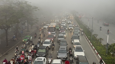
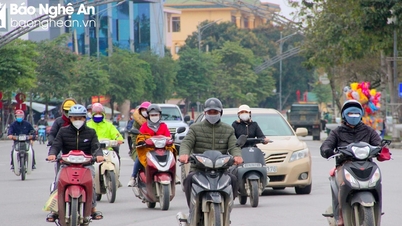
On land, the National Center for Hydro-Meteorological Forecasting predicts that from 8:30 PM on September 25th to 1:30 AM on September 26th, the provinces in the area will continue to experience rain with accumulated rainfall generally ranging from 20-40 mm, and in some places exceeding 80 mm.
Warning of the risk of flash floods on small rivers and streams, and landslides on slopes in the above provinces, especially in the following communes/wards: Cat Tien, Cat Tien 2, Da Teh, Da Teh 2, Da Teh 3, Di Linh, Ward 1 Bao Loc, Ward 2 Bao Loc, Ward 3 Bao Loc, B'Lao; Bao Lam 2, Da Huoai 2, Hoa Ninh; Bac Ruong, Bao Lam 3, Cat Tien 3, Da Huoai, Da Huoai 3, Dong Giang, Dong Kho, Ham Thuan, Ham Thuan Bac, Hoa Bac, Kien Duc, Nam Thanh, Nghi Duc, Nhan Co, Quang Hoa, Quang Khe, Quang Son, Quang Tin, Ta Dung (Lam Dong province); Dak Lua; Bom Bo, Bu Dang, Dak Nhau, Dong Tam, Long Ha, Minh Duc, Nghia Trung, Nha Bich, An Loc, Binh Long, Binh Phuoc , Chon Thanh, Dong Xoai, Minh Hung, Phu Lam, Phu Ly, Phu Nghia, Phu Rieng, Phu Trung, Phuoc Son, Tan Hung, Tan Khai, Tan Loi, Tan Quan, Tho Son, Thuan Loi (Dong Nai province).
Level 1 risk of natural disasters due to flash floods, landslides, and land subsidence caused by heavy rain or runoff.
Flash floods and landslides can have very serious impacts on the environment, threatening people's lives; causing localized traffic congestion, affecting the movement of vehicles; destroying public and economic infrastructure, causing damage to production and socio-economic activities.
The hydrometeorological agency recommends that local authorities pay attention to reviewing bottlenecks and vulnerable locations in the area to have prevention and response measures.
From 4 PM to 7 PM on September 25th, moderate to heavy rain fell in the provinces of Lam Dong and Dong Nai, with rainfall amounts such as: Quang Ngai - Cat Tien (Lam Dong) 45.2 mm, An Nhon - Da Teh (Lam Dong) 36.4 mm; Phuoc Tan (Dong Nai) 59 mm, Dak Lua (Dong Nai) 51.6 mm...
Soil moisture models show that some areas in the above provinces are close to saturation (over 85%) or have reached saturation.
Source: https://www.sggp.org.vn/bao-bualoi-se-di-vao-khu-vuc-giua-bien-dong-vao-dem-26-9-post814751.html


![[Photo] Closing Ceremony of the 10th Session of the 15th National Assembly](/_next/image?url=https%3A%2F%2Fvphoto.vietnam.vn%2Fthumb%2F1200x675%2Fvietnam%2Fresource%2FIMAGE%2F2025%2F12%2F11%2F1765448959967_image-1437-jpg.webp&w=3840&q=75)
![[Photo] Prime Minister Pham Minh Chinh holds a phone call with the CEO of Russia's Rosatom Corporation.](/_next/image?url=https%3A%2F%2Fvphoto.vietnam.vn%2Fthumb%2F1200x675%2Fvietnam%2Fresource%2FIMAGE%2F2025%2F12%2F11%2F1765464552365_dsc-5295-jpg.webp&w=3840&q=75)


![[Infographic] Preventing students from making their own firecrackers: 7 things parents need to know](https://vphoto.vietnam.vn/thumb/402x226/vietnam/resource/IMAGE/2025/12/11/1765466656703_img_0320_20251211183542.jpeg)


![[OFFICIAL] MISA GROUP ANNOUNCES ITS PIONEERING BRAND POSITIONING IN BUILDING AGENTIC AI FOR BUSINESSES, HOUSEHOLDS, AND THE GOVERNMENT](https://vphoto.vietnam.vn/thumb/402x226/vietnam/resource/IMAGE/2025/12/11/1765444754256_agentic-ai_postfb-scaled.png)


Comment (0)